St Kilda, Queensland

Last updated

St Kilda
Queensland
Australia Queensland location map.svg
Red pog.svg
St Kilda
Coordinates 25°03′09″S151°55′14″E / 25.0524°S 151.9205°E / -25.0524; 151.9205 (St Kilda (centre of locality))
Population90 (2016 census) [1]
 • Density5.00/km2 (12.9/sq mi)
Postcode(s) 4671
Area18.0 km2 (6.9 sq mi)
Time zone AEST (UTC+10:00)
Location
LGA(s) Bundaberg Region
State electorate(s) Callide
Federal division(s) Flynn
Suburbs around St Kilda:
Dalysford Tirroan Redhill Farms
Horse Camp St Kilda Skyring Reserve
Horse Camp Wallaville Wallaville

St Kilda is a rural locality in the Bundaberg Region, Queensland, Australia. [2] In the 2016 census, St Kilda had a population of 90 people. [1]

Contents

Geography

St Kilda is a freehold farming area with cropping in the flatter northern part of the locality and grazing in the hillier land in the rest of the locality. It is bounded in the south-west by Currajong Creek. [3]

History

St Kilda State School was opened on 20 November 1915 by Thomas Armfield, the Member of the Queensland Legislative Assembly for Musgrave. It was an open air school. It closed in 1922. [4] [5] It was on the south-east corner of Currajong Farms Road and Booths Road ( 25°02′59″S151°55′48″E / 25.04978°S 151.93009°E / -25.04978; 151.93009 (St Kilda State School (former)) ). [6] [3]

In the 2016 census, St Kilda had a population of 90 people. [1]

Education

There are no schools in St Kilda. The nearest government primary schools are Wallaville State School in neighbouring Wallaville to the south-east and Gin Gin State School in Gin Gin to the north-east. The nearest government secondary school is Gin Gin State High School in Gin Gin. [3]

Related Research Articles

<span class="mw-page-title-main">Gin Gin, Queensland</span> Town in Queensland, Australia

Gin Gin is a rural town and locality in the Bundaberg Region, Queensland, Australia. In the 2021 census, the locality of Gin Gin had a population of 1,139 people.

<span class="mw-page-title-main">Mount Perry, Queensland</span> Town in Queensland, Australia

Mount Perry is a rural town and locality in the North Burnett Region, Queensland, Australia. In the 2016 census, the locality of Mount Perry had a population of 538 people.

<span class="mw-page-title-main">Wallaville</span> Town in Queensland, Australia

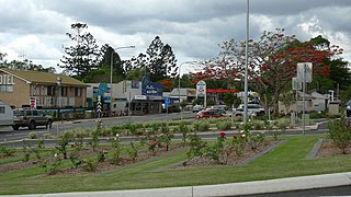
Wallaville is a rural town and locality in the Bundaberg Region, Queensland, Australia. It is 372 kilometres (231 mi) north of the state capital, Brisbane and 43 kilometres (27 mi) south west of the regional centre of Bundaberg. In the 2016 census, Wallaville had a population of 410 people.

<span class="mw-page-title-main">South Kolan</span> Town in Queensland, Australia

South Kolan is a rural locality in the Bundaberg Region, Queensland, Australia. In the 2021 census, South Kolan had a population of 1,258 people.

McIlwraith is a rural locality in the Bundaberg Region, Queensland, Australia. In the 2021 census, McIlwraith had a population of 202 people.

Sharon is a rural locality in the Bundaberg Region, Queensland, Australia. In the 2016 census, Sharon had a population of 1,316 people.

Booyal is a town and a locality in the Bundaberg Region, Queensland, Australia. In the 2016 census, Booyal had a population of 275 people.

Bungadoo is a rural locality in the Bundaberg Region, Queensland, Australia. The area was formerly known as Albionville. In the 2021 census, Bungadoo had a population of 342 people.

<span class="mw-page-title-main">Bucca, Queensland</span> Suburb of Bundaberg Region, Queensland, Australia

Bucca is a rural locality in the Bundaberg Region, Queensland, Australia. In the 2016 census, Bucca had a population of 1,027 people. The neighbourhood of Kolan is within the locality.

Gaeta is a rural locality in the Bundaberg Region, Queensland, Australia. In the 2016 census Gaeta had a population of 125 people.

Moolboolaman is a rural locality in the Bundaberg Region, Queensland, Australia. In the 2016 census, Moolboolaman had a population of 434 people.

Tirroan is a rural town and a locality in the Bundaberg Region, Queensland, Australia. In the 2021 census, the locality of Tirroan had a population of 150 people.

Good Night is a rural locality split between the Bundaberg Region and the North Burnett Region, Queensland, Australia. It is also written as Goodnight. In the 2016 census, Good Night had a population of 117 people.

Morganville is a rural locality in the Bundaberg Region, Queensland, Australia.

Monduran is a rural locality in the Bundaberg Region, Queensland, Australia. In the 2016 census, Monduran had a population of 91 people.

Duingal is a locality in the Bundaberg Region, Queensland, Australia. In the 2016 census, Duingal had a population of 77 people.

Dalga is a locality in the Bundaberg Region, Queensland, Australia. In the 2016 census, Dalga had a population of 3 people.

Dalysford is a rural locality in the Bundaberg Region, Queensland, Australia.

Kolonga is a rural locality in the Bundaberg Region, Queensland, Australia. In the 2016 census, Kolonga had a population of 49 people.

Lake Monduran is a rural locality in the Bundaberg Region, Queensland, Australia. In the 2016 census Lake Monduran had a population of 3 people.

References

  1. 1 2 3 Australian Bureau of Statistics (27 June 2017). "St Kilda (SSC)". 2016 Census QuickStats. Retrieved 20 October 2018. OOjs UI icon edit-ltr-progressive.svg
  2. "St Kilda – locality in Bundaberg Region (entry 44772)". Queensland Place Names. Queensland Government . Retrieved 26 December 2020.
  3. 1 2 3 "Queensland Globe". State of Queensland . Retrieved 27 January 2023.
  4. Queensland Family History Society (2010), Queensland schools past and present (Version 1.01 ed.), Queensland Family History Society, ISBN   978-1-921171-26-0
  5. "OPEN-AIR SCHOOLS". The Bundaberg Mail And Burnett Advertiser . Vol. 45, no. 5624. Queensland, Australia. 17 April 1915. p. 2. Archived from the original on 26 January 2021. Retrieved 1 August 2017 via National Library of Australia.
  6. "County of Bowen" (Map). Queensland Government. 1923. Retrieved 27 January 2023.