Burnett Heads, Queensland

Last updated

Burnett Heads
Queensland
Welcome to Burnett Heads.jpg
Entering Burnett Heads
Australia Queensland location map.svg
Red pog.svg
Burnett Heads
Coordinates 24°46′27″S152°25′02″E / 24.7741°S 152.4172°E / -24.7741; 152.4172 (Burnett Heads (town centre))
Population2,908 (2021 census) [1]
 • Density164.3/km2 (425.5/sq mi)
Postcode(s) 4670
Area17.7 km2 (6.8 sq mi)
Time zone AEST (UTC+10:00)
Location
LGA(s) Bundaberg Region
State electorate(s) Burnett
Federal division(s) Hinkler
Localities around Burnett Heads:
Fairymead Coral Sea Coral Sea
Fairymead Burnett Heads Coral Sea
Rubyanna Qunaba Mon Repos

Burnett Heads is a coastal town and locality in the Bundaberg Region, Queensland, Australia. [2] [3] In the 2021 census, the locality of Burnett Heads had a population of 2,908 people. [1]

Contents

Geography

The locality of Burnett Heads is on the southern side of the Burnett River at its mouth into the Coral Sea.The river forms the western and northern boundaries, while the ocean forms most of the eastern boundary. [4] [5]

The land use is a mixture of residential (mostly with proximity to the coast), industrial (mostly the Port of Bundaberg) and some agricultural use (growing sugarcane). There is a network of cane tramways to transport the harvested sugarcane to the Millaquin sugar mill for processing. [5]

History

Burnett Heads Provisional School opened on 3 April 1878. On 17 September 1888, it became Burnett Heads State School. [6]

In February 1883, land surveyed by Charlton and Gardiner, licensed surveyors, in the township of New Bundaberg was offered for sale in the Victoria Hall, Bundaberg. The locality map advertising the sale also shows land in the Barolin Marine Township Estate to be offered for sale on the same day. [7] [8] The Maryborough Chronicle later reported that the Bundaberg town allotments sold well, recording the buyers and prices paid while the Barolin estate did not sell so well on the day. [9] In February 1883 and Barolin Estate was auctioned by three auctioneers: Bryant and Co., John Cameron and W. E. Curtis. A map advertising the estate shows the estate to be close to Burnett River. [10] [11]

Methodist services were held at the Burnett Heads State School, until a Methodist Church was opened in 1903. [12]

Burnett Heads Post Office opened by 1919 (a receiving office had been open from 1888), closed in 1924 and reopened around 1942. [13]

On Sunday 3 May 1931, Archbishop James Duhig consecrated a new Roman Catholic Church in Burnett Heads. It was entirely funded by the Zunker family in memory of their dead parents. Over 1000 people attended the ceremony. [14]

Archbishop William Wand laid the foundation stone for St John the Divine Anglican Church on Sunday 6 August 1939. [15] The land for the church had been donated by Christian Mittleheuser. [16] [17] [18]

In 1958, the Port of Bundaberg was established at Burnett Heads to better support the sugar industry and the larger ships being employed. The port of Bundaberg originally operated from the town reach of the Burnett River at Bundaberg with the Bundaberg Harbour Board being established in 1895. A major dredging project was undertaken in 2001 to cater for even larger vessels. [19] [20] [ better source needed ]

Demographics

In the 2016 census, the locality of Burnett Heads had a population of 2,656 people. Aboriginal and Torres Strait Islander people made up 3.8% of the population. 80.5% of people were born in Australia. The next most common country of birth was England at 4.0. 91.9% of people spoke only English at home. The most common responses for religion were No Religion 31.0%, Anglican 22.5%, Catholic 16.3% and Uniting Church 7.7%. [21]

In the 2021 census, the locality of Burnett Heads had a population of 2,908 people. [1]

Heritage

The town's most notable feature is its historic timber lighthouse, the Old Burnett Heads Light, dating from 1873. The structure, originally sited on South Head (the southern entrance to the Burnett River), was replaced by a modern structure in 1971; the original lighthouse was restored and moved to a local park off Mittelheuser Street. It includes the original Fresnel lens. [22]

Economy

The Port of Bundaberg is located on the Burnett River at Wharf Drive ( 24°46′16″S152°22′59″E / 24.771°S 152.383°E / -24.771; 152.383 (Port of Bundaberg) ). It is operated by Gladstone Ports Corporation. It has two wharves: [19] [20] [ better source needed ]

Education

Burnett Heads State School is a government primary (Prep-6) school for boys and girls at Burnett Heads Road ( 24°46′18″S152°24′52″E / 24.7717°S 152.4145°E / -24.7717; 152.4145 (Burnett Heads State School) ). [23] [24] In 2018, the school had an enrolment of 146 students with 11 teachers (9 full-time equivalent) and 13 non-teaching staff (8 full-time equivalent). [25]

There is no government secondary school in Burnett Heads. The nearest government secondary school is Kepnock State High School in Kepnock to the south-east. [5]

Facilities

Burnett Heads Fire Station is at 15 Brewer Street ( 24°45′50″S152°24′36″E / 24.7639°S 152.4100°E / -24.7639; 152.4100 (Burnett Heads Fire Station) ). [26]

Burnett Heads SES Facility is at 13 Brewer Street beside the fire station ( 24°45′49″S152°24′36″E / 24.7637°S 152.4100°E / -24.7637; 152.4100 (Burnett Heads SES Facility) ). [26]

Volunteer Marine Rescue Bundaberg has its base at 51 Harbour Esplanade ( 24°45′39″S152°24′05″E / 24.7608°S 152.4014°E / -24.7608; 152.4014 (Volunteer Marine Rescue Bundaberg) ). [26] Its area of coverage is approximately 4,000 square nautical miles (14,000 km2; 5,300 sq mi) off the Central Queensland coast from Fairfax Islands ( 23°51′22″S152°22′16″E / 23.856°S 152.371°E / -23.856; 152.371 (Fairfax Islands) ) to the north, to Burrum River ( 25°10′44″S152°36′50″E / 25.179°S 152.614°E / -25.179; 152.614 (Burrum River) ) to the south, and to the ocean side of Fraser Island (approx 24°41′38″S153°17′42″E / 24.694°S 153.295°E / -24.694; 153.295 (Ocean east of Fraser Island) ) to the east. [27]

Amenities

St John the Divine Anglican Church is at 1 Paul Mittelheuser Street ( 24°45′48″S152°24′29″E / 24.7634°S 152.4080°E / -24.7634; 152.4080 (St John the Divine Anglican Church) ). A service is held every Saturday. [28]

Burnett Heads Uniting Church is at 14 Zunker Street ( 24°45′53″S152°24′41″E / 24.7648°S 152.4113°E / -24.7648; 152.4113 (Burnett Heads Uniting Church) ). A service is held every Sunday morning. [29] [30] [31] [32] [33]

There are a number of parks in the area:

Events

In recognition of its lighthouses, Burnett Heads stages the annual Lighthouse Festival on the last Saturday in October. [35]

Related Research Articles

<span class="mw-page-title-main">Bundaberg</span> City in Queensland, Australia

Bundaberg is a city in the Bundaberg Region, Wide Bay, Queensland, Australia, and is the tenth largest city in the state. It is a major centre of the Wide Bay–Burnett geographical region. The Bundaberg central business district is situated along the southern bank of the Burnett River, about 20 km (12 mi) from its mouth at Burnett Heads, and flows into the Coral Sea. The city is sited on a rich coastal plain, supporting one of the nation's most productive agricultural regions. The area of Bundaberg is the home of the Taribelang-Bunda, Goreng Goreng, Gurang, and Bailai peoples. Popular nicknames for Bundaberg include "Bundy", "Rum City", and "The 'Berg". The demonym of Bundaberg is Bundabergian. In the 2021 census, Bundaberg's urban area has a population of 73,747 people.

<span class="mw-page-title-main">Maryborough, Queensland</span> City in Queensland, Australia

Maryborough is a city and a suburb in the Fraser Coast Region, Queensland, Australia. In the 2021 census, the suburb of Maryborough had a population of 15,287 people.

<span class="mw-page-title-main">Childers, Queensland</span> Town in Queensland, Australia

Childers is a rural town and locality in the Bundaberg Region, Queensland, Australia. In the 2021 census, the locality of Childers had a population of 1,682 people.

<span class="mw-page-title-main">Bargara, Queensland</span> Town in Queensland, Australia

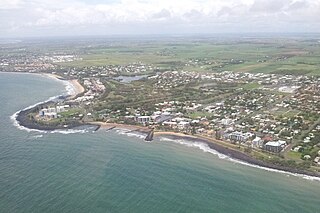
Bargara is a coastal town and suburb in the Bundaberg Region, Queensland, Australia. In the 2021 census, the suburb of Bargara had a population of 8,883 people.

<span class="mw-page-title-main">Bundaberg Region</span> Local government area in Queensland, Australia

The Bundaberg Region is a local government area in the Wide Bay–Burnett region of Queensland, Australia, about 360 kilometres (220 mi) north of Brisbane, the state capital. It is centred on the city of Bundaberg, and also contains a significant rural area surrounding the city. It was created in 2008 from a merger of the City of Bundaberg with the Shires of Burnett, Isis and Kolan.

<span class="mw-page-title-main">Moore Park Beach, Queensland</span> Town in Queensland, Australia

Moore Park Beach is a coastal rural locality in the Bundaberg Region, Queensland, Australia. The coastal town of Moore Park is within the locality.

The Shire of Woongarra was a local government area located to the south and east of the regional city of Bundaberg. The shire, administered from Bundaberg itself, covered an area of 722.4 square kilometres (278.9 sq mi), and existed as a local government entity from 1885 until 1994, when it amalgamated with Gooburrum to form the Shire of Burnett.

<span class="mw-page-title-main">Bundaberg Central, Queensland</span> Suburb of Bundaberg, Queensland, Australia

Bundaberg Central is the central suburb and central business district of Bundaberg in the Bundaberg Region, Queensland, Australia. In the 2021 census, Bundaberg Central had a population of 162 people.

<span class="mw-page-title-main">Windermere, Queensland</span> Suburb of Bundaberg Region, Queensland, Australia

Windermere is a rural locality in the Bundaberg Region, Queensland, Australia. In the 2021 census, Windermere had a population of 188 people.

<span class="mw-page-title-main">South Kolan</span> Town in Queensland, Australia

South Kolan is a rural locality in the Bundaberg Region, Queensland, Australia. In the 2021 census, the locality of South Kolan had a population of 1,258 people.

<span class="mw-page-title-main">Shire of Barolin</span> Local government area of Queensland, Australia

The Shire of Barolin was a local government area located in the Wide Bay–Burnett region of Queensland, Australia. It was the area south of the Burnett River but excluding the urban area of Bundaberg which was initially in Bundaberg Division. It existed from 1879 to 1917.

<span class="mw-page-title-main">Bundaberg North, Queensland</span> Suburb of Bundaberg, Queensland, Australia

Bundaberg North is a suburb of Bundaberg in the Bundaberg Region, Queensland, Australia. It occupies the developed area north of the Burnett River, opposite the Bundaberg CBD. In the 2021 census, Bundaberg North had a population of 5,563 people.

<span class="mw-page-title-main">Oakwood, Queensland</span> Suburb of Bundaberg Region, Queensland, Australia

Oakwood is a rural locality in the Bundaberg Region, Queensland, Australia. In the 2021 census, Oakwood had a population of 364 people.

<span class="mw-page-title-main">Mon Repos, Queensland</span> Suburb of Bundaberg, Queensland, Australia

Mon Repos is a coastal locality in the Bundaberg Region, Queensland, Australia. In the 2021 census, Mon Repos had a population of 24 people.

<span class="mw-page-title-main">Kalkie, Queensland</span> Suburb of Bundaberg, Queensland, Australia

Kalkie is a suburb of Bundaberg in the Bundaberg Region, Queensland, Australia. In the 2021 census, Kalkie had a population of 2,968 people.

<span class="mw-page-title-main">Qunaba, Queensland</span> Suburb of Bundaberg Region, Queensland, Australia

Qunaba is a rural locality in the Bundaberg Region, Queensland, Australia. In the 2021 census, Qunaba had a population of 836 people.

Sharon is a rural locality in the Bundaberg Region, Queensland, Australia. In the 2021 census, Sharon had a population of 1,209 people.

<span class="mw-page-title-main">Coral Cove, Queensland</span> Suburb of Bundaberg, Queensland, Australia

Coral Cove is a coastal locality in the Bundaberg Region, Queensland, Australia. It has been used as a diving point by tourists and contains the Coral Cove Golf course. In the 2021 census, Coral Cove had a population of 1,462 people.

Gooburrum is a rural locality in the Bundaberg Region, Queensland, Australia. In the 2021 census, Gooburrum had a population of 1,518 people. The neighbourhood of Tantitha is within the locality.

Walkervale is a suburb of Bundaberg in the Bundaberg Region, Queensland, Australia. In the 2021 census, Walkervale had a population of 2,981 people.

References

  1. 1 2 3 Australian Bureau of Statistics (28 June 2022). "Burnett Heads (SAL)". 2021 Census QuickStats. Retrieved 28 February 2023. OOjs UI icon edit-ltr-progressive.svg
  2. "Burnett Heads – town in Bundaberg Region (entry 5382)". Queensland Place Names. Queensland Government . Retrieved 26 December 2020.
  3. "Burnett Heads – locality in Bundaberg Region (entry 44698)". Queensland Place Names. Queensland Government . Retrieved 26 December 2020.
  4. Google (20 August 2021). "Burnett Heads, Queensland" (Map). Google Maps . Google. Retrieved 20 August 2021.
  5. 1 2 3 "Queensland Globe". State of Queensland . Retrieved 30 August 2021.
  6. Queensland Family History Society (2010), Queensland schools past and present (Version 1.01 ed.), Queensland Family History Society, ISBN   978-1-921171-26-0
  7. "Township of New Bundaberg". rosettadel.slq.qld.gov.au. Archived from the original on 1 April 2021. Retrieved 27 August 2019.
  8. "Classified Advertising". The Brisbane Courier . Vol. XXXVII, no. 7, 818. Queensland, Australia. 1 February 1883. p. 8. Archived from the original on 1 April 2021. Retrieved 27 August 2019 via National Library of Australia.
  9. "NEW BUNDABERG SALE". Maryborough Chronicle, Wide Bay and Burnett Advertiser . No. 2, 994. Queensland, Australia. 19 February 1883. p. 3. Archived from the original on 1 April 2021. Retrieved 27 August 2019 via National Library of Australia.
  10. "Barolin Estate". State Library of Queensland. 1 February 1883. hdl: 10462/comp/10236 .
  11. "Advertising". Maryborough Chronicle, Wide Bay and Burnett Advertiser . No. 2, 977. Queensland, Australia. 30 January 1883. p. 3. Archived from the original on 1 April 2021. Retrieved 24 September 2019 via National Library of Australia.
  12. Methodist Church of Australasia. Bundaberg Circuit (1925), Jubilee souvenir 1875-1925, The Church, archived from the original on 30 August 2021, retrieved 30 August 2021
  13. Phoenix Auctions History. "Post Office List". Phoenix Auctions. Archived from the original on 1 April 2021. Retrieved 20 March 2021.
  14. "CHURCH CONSECRATED". The Brisbane Courier . No. 22, 858. Queensland, Australia. 4 May 1931. p. 15. Archived from the original on 1 April 2021. Retrieved 23 September 2020 via National Library of Australia.
  15. "40 NEW CHURCHES BY END OF YEAR". The Courier-mail . No. 1850. Queensland, Australia. 7 August 1939. p. 2. Archived from the original on 1 April 2021. Retrieved 23 September 2020 via National Library of Australia.
  16. "St John the Divine Anglican Church". Churches Australia. Archived from the original on 1 October 2020. Retrieved 23 September 2020.
  17. Reid, Emma (25 July 2019). "St John the Divine Anglican Church's 80th birthday – Bundaberg Now". Bundaberg Now. Archived from the original on 26 September 2020. Retrieved 23 September 2020.
  18. "Year Book" (PDF). Anglican Archdiocese of Brisbane. 2019. p. 135. Archived (PDF) from the original on 15 September 2020. Retrieved 15 September 2020.
  19. 1 2 "Port of Bundaberg". Gladstone Ports Corporation. Archived from the original on 30 August 2021. Retrieved 30 August 2021.
  20. 1 2 "Precinct Outlook: Port of Bundaberg" (PDF). Gladstone Ports Corporation. p. 3. Retrieved 24 July 2023.
  21. Australian Bureau of Statistics (27 June 2017). "Burnett Heads (SSC)". 2016 Census QuickStats. Retrieved 20 October 2018. OOjs UI icon edit-ltr-progressive.svg
  22. Rowlett, Russ. "Lighthouses of Australia: Southern Queensland". The Lighthouse Directory. University of North Carolina at Chapel Hill.
  23. "State and non-state school details". Queensland Government. 9 July 2018. Archived from the original on 21 November 2018. Retrieved 21 November 2018.
  24. "Burnett Heads State School". Archived from the original on 4 November 2013. Retrieved 21 November 2018.
  25. "ACARA School Profile 2018". Australian Curriculum, Assessment and Reporting Authority. Archived from the original on 27 August 2020. Retrieved 28 January 2020.
  26. 1 2 3 "Emergency services facilities - Queensland". Queensland Open Data. Queensland Government. 18 November 2020. Archived from the original on 24 November 2020. Retrieved 24 November 2020.
  27. "VMR Bundaberg". Marine Rescue Queensland. Archived from the original on 30 August 2021. Retrieved 30 August 2021.
  28. "Worship". Anglican Parish of Bundaberg. Archived from the original on 23 September 2020. Retrieved 23 September 2020.
  29. "Bargara Uniting Church". Bargara Uniting Church. Archived from the original on 5 March 2022. Retrieved 1 April 2021.
  30. "Worship Services". Bundaberg Uniting Church. Archived from the original on 3 March 2021. Retrieved 1 April 2021.
  31. Google (1 April 2021). "Burnett Heads Uniting Church" (Map). Google Maps . Google. Retrieved 1 April 2021.
  32. "Find a Church". Uniting Church in Australia, Queensland Synod. Archived from the original on 24 October 2020. Retrieved 22 November 2020.
  33. "Burnett Heads Uniting Church". Churches Australia. Archived from the original on 29 August 2021. Retrieved 29 August 2021.
  34. 1 2 3 4 5 6 7 8 9 "Land for public recreation - Queensland". Queensland Open Data. Queensland Government. 20 November 2020. Archived from the original on 22 November 2020. Retrieved 22 November 2020.
  35. "The Lighthouse Festival". Archived from the original on 24 July 2013. Retrieved 26 June 2017.