Burrum River

Last updated

Burrum
Australia Queensland relief location map.jpg
Red pog.svg
Location of Burrum River mouth in Queensland
Etymology Kabi: rocks interrupting river flow [1]
Location
Country Australia
State Queensland
Region Wide Bay-Burnett
Physical characteristics
Source Lake Lenthall
  location Lake Lenthall
  elevation24 m (79 ft)
Mouth Hervey Bay, Coral Sea
  location
Burrum Heads
  coordinates
25°10′46″S152°37′01″E / 25.17944°S 152.61694°E / -25.17944; 152.61694
  elevation
0 m (0 ft)
Length31 km (19 mi)
Basin size2,327.4 km2 (898.6 sq mi) [2]
Discharge 
  locationNear mouth
  average8 m3/s (250 GL/a) [2]
Basin features
National park Burrum Coast National Park
[3]

The Burrum River is a river in the Wide Bay-Burnett region of Queensland, Australia.

Contents

Course and features

The river rises within Lake Lenthall, impounded by Lenthalls Dam at the confluence of several smaller watercourses including Harwood Creek, Woolmer Creek and Duckinwilla Creek, near the town of Burrum. Below Lenthalls Dam the river is impounded by Burrum River Weir No.2 (built in 1951) and Burrum River Weir No.1 (built in 1900). [4] The river flows in northerly direction and is crossed by the Bruce Highway near Howard. The river flows past Pacific Haven before the Isis River joins with the Burrum River at the southern edge of the Burrum Coast National Park. Together with the Gregory River, it discharges into the Burrum Fish Habitat Area in Hervey Bay that flows out to the Coral Sea, at Burrum Heads. The river descends 27 metres (89 ft) over its 31-kilometre (19 mi) course. [3] An estuary is formed at the mouth of the river. The Isis and Gregory Rivers also discharge into the 12 kilometres (7 mi) long and between 2 kilometres (1 mi) and 500 metres (1,640 ft) wide estuary. The area includes intensive inter-tidal flats, shallow sand banks, a meandering main channel with small patched of fringing mangroves. [4]

The catchment area of the river occupies an 3,371 square kilometres (1,302 sq mi) of which an area of 108 square kilometres (42 sq mi) is composed of riverine wetlands. [5] The catchment area is generally low and flat and is situated between the Burnett and Mary River catchments. [4]

The river has a mean annual discharge of 153 gigalitres (200,116,445 cu yd). [4]

Etymology

The river draws its name from the indigenous Australian Kabi language for a word meaning rocks interrupting river flow. [1]

See also

Related Research Articles

<span class="mw-page-title-main">Fitzroy River (Queensland)</span> River in Queensland, Australia

The Fitzroy River is a river in Central Queensland, Australia. Its catchment covers an area of 142,665 square kilometres (55,083 sq mi), making it the largest river catchment flowing to the eastern coast of Australia. It is also the largest river basin that discharges onto the Great Barrier Reef.

<span class="mw-page-title-main">Burdekin River</span> River in Queensland, Australia

The Burdekin River is a river in North and Far North Queensland, Australia. The river rises on the northern slopes of Boulder Mountain at Valley of Lagoons, part of the western slope of the Seaview Range, and flows into the Coral Sea at Upstart Bay over 200 kilometres (124 mi) to the southeast of the source, with a catchment area of approximately 130,000 square kilometres (50,000 sq mi). The Burdekin River is Australia's largest river by (peak) discharge volume.

<span class="mw-page-title-main">Balonne River</span> River in Queensland, Australia

The Balonne River, part of the Murray-Darling Basin system, is a short yet significant part of the inland river group of South West Queensland, Australia.

<span class="mw-page-title-main">Flinders River</span> River in Queensland, Australia

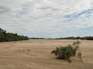
The Flinders River is the longest river in Queensland, Australia, at approximately 1,004 kilometres (624 mi). It was named in honour of the explorer Matthew Flinders. The catchment is sparsely populated and mostly undeveloped. The Flinders rises on the western slopes of the Great Dividing Range in North West Queensland and flows generally north-west through the Gulf Country, across a large, flat clay pan, before entering the Gulf of Carpentaria.

<span class="mw-page-title-main">Mary River (Queensland)</span> River in Queensland, Australia

The Mary River is a major river system in the South East and Wide Bay–Burnett regions of Queensland, Australia.

<span class="mw-page-title-main">Maroon Dam</span> Dam in South East Queensland

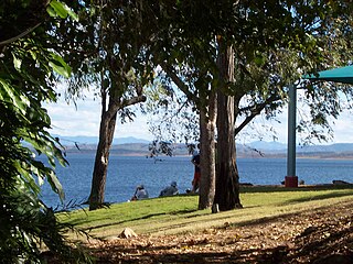
The Maroon Dam is a rock and earth-fill embankment dam with an un-gated spillway across the Burnett Creek that is located in the South East region of Queensland, Australia. The main purpose of the dam is for irrigation of the Scenic Rim Regional Council region. The impounded reservoir is also called Maroon Dam.

<span class="mw-page-title-main">Gilbert River (Queensland)</span> River in Queensland, Australia

The Gilbert River is located in Far North Queensland, Australia. When combined with the Einasleigh River, the river system is the largest river system in northern Australia.

Lake Lenthall is a lake created by the Lenthalls Dam in Duckinwilla, Fraser Coast Region, Queensland, Australia. As a result of a 518 square kilometres (200 sq mi) catchment, it takes a short time in moderate rain events to fill Lake Lenthall to 100% capacity.

<span class="mw-page-title-main">Boyne River (Central Queensland)</span> River in Queensland, Australia

The Boyne River is a river in Central Queensland, Australia.

<span class="mw-page-title-main">Fortescue River</span> River in the Pilbara, Western Australia

The Fortescue River is an ephemeral river in the Pilbara region of Western Australia. It is the third longest river in the state.

The Isis River is a river in the Wide Bay–Burnett region of Queensland, Australia.

The Settlement Creek is a creek in the Northern Territory and the state of Queensland, Australia.

<span class="mw-page-title-main">Gregory River (Australia)</span> River in Queensland and Northern Territory, Australia

The Gregory River is a river in the Northern Territory and the state of Queensland, Australia. The river is the largest perennial river in arid and semi-arid Queensland, one of the few permanently flowing rivers in the northwest of Queensland.

The Haughton River is a river in North Queensland, Australia.

The Holroyd River is a river located on the Cape York Peninsula in Far North Queensland, Australia.

The Barratta Creek is a creek in North Queensland, Australia.

<span class="mw-page-title-main">Bowen River (Queensland)</span> River in Queensland, Australia

The Bowen River is a river in North Queensland, Australia.

The Elliott River is a river in the Wide Bay–Burnett region of Queensland, Australia.

The Mission River is a river in Far North Queensland, Australia.

<span class="mw-page-title-main">Proserpine River</span> River in Queensland, Australia

The Proserpine River is a river in Whitsunday Region of Queensland, Australia.

References

  1. 1 2 "Burrum River (entry 5451)". Queensland Place Names. Queensland Government . Retrieved 26 June 2015.
  2. 1 2 "East Coastal Watersheds".
  3. 1 2 "Map of Burrum River, QLD". Bonzle Digital Atlas of Australia. Archived from the original on 23 September 2015. Retrieved 23 June 2015.
  4. 1 2 3 4 Walker, Michael (June 2008). "Burrum Catchment - Water Quality Improvement Plan" (PDF). Burnett Mary Regional Group. Archived from the original (PDF) on 22 March 2015. Retrieved 24 June 2015.
  5. "Burrum river drainage basin". WetlandInfo. Queensland Government. Archived from the original on 19 June 2015. Retrieved 23 June 2015.