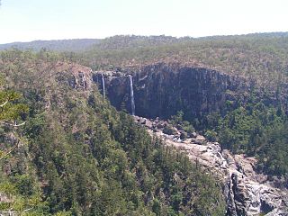
The Great Dividing Range, also known as the East Australian Cordillera or the Eastern Highlands, is a cordillera system in eastern Australia consisting of an expansive collection of mountain ranges, plateaus and rolling hills, that runs roughly parallel to the east coast of Australia and forms the fifth-longest land-based mountain chain in the world, and the longest entirely within a single country. It is mainland Australia's most substantial topographic feature and serves as the definitive watershed for the river systems in eastern Australia, hence the name.

Cape York Peninsula is a peninsula located in Far North Queensland, Australia. It is the largest unspoiled wilderness in northern Australia. The land is mostly flat and about half of the area is used for grazing cattle. The relatively undisturbed eucalyptus-wooded savannahs, tropical rainforests and other types of habitat are now recognised and preserved for their global environmental significance. Although much of the peninsula remains pristine, with a diverse repertoire of endemic flora and fauna, some of its wildlife may be threatened by industry and overgrazing as well as introduced species and weeds.

Barwon River, a perennial river that is part of the Murray–Darling basin, is located in the north-west slopes and Orana regions of New South Wales, Australia.

Laura is a rural town and locality in the Shire of Cook, Queensland, Australia. In the 2016 census the locality of Laura had a population of 228 people.

The Barron River is located on the Atherton Tablelands inland from Cairns in North Queensland, Australia. With its headwaters below Mount Hypipamee, the 165-kilometre (103 mi)-long river with a catchment area of approximately 2,138 square kilometres (825 sq mi) forms through run off from the Mount Hypipamee National Park, flows through Lake Tinaroo, and eventually empties into the Coral Sea near Smithfield.

The Herbert River is a river in Far North Queensland, Australia. The southernmost of Queensland's wet tropics river systems, it was named in 1864 by George Elphinstone Dalrymple explorer, after Robert George Wyndham Herbert, the first Premier of Queensland.

The Pioneer River is a river in North Queensland, Australia. The 120-kilometre (75 mi) long river flows through the city of Mackay.

The Coomera River is a perennial river in the South East region of Queensland, Australia. Its catchment lies within the Gold Coast and Scenic Rim Region local government areas and covers an area of 489 square kilometres (189 sq mi).

The Normanby River, comprising the East Normanby River, the West Normanby River, the East Normanby River North Branch, the East Normanby River South Branch and the Granite Normanby River, is a river system in Far North Queensland, Australia.

The Wenlock River is a river located on the Cape York Peninsula in Far North Queensland, Australia.
The Ducie River is a river located on the Cape York Peninsula in Far North Queensland, Australia.

The Annan River is a river in the Wet Tropics of Far North Queensland, Australia.

The Johnstone River, comprising the North Johnstone River and the South Johnstone River, is a river system in Far North and North Queensland, Australia.

Duchess is a rural town and locality in the Shire of Cloncurry, Queensland, Australia. In the 2016 census, Duchess had a population of 23 people.

The Russell River is a river in Far North Queensland, Australia. The 59-kilometre (37 mi)-long river flows towards the Coral Sea and is located approximately 60 kilometres (37 mi) south of Cairns.
The Walsh River is a river located on the Cape York Peninsula of Far North Queensland, Australia.

The Mossman River is a river in the Cape York Peninsula of Far North Queensland, Australia.
Gladstone–Mount Larcom Road is a continuous 32.1 kilometres (19.9 mi) road route in the Gladstone region of Queensland, Australia. The route is signed as State Route 58. Gladstone–Mount Larcom Road is a state-controlled regional road. As part of State Route 58 it provides an alternate route between Mount Larcom and Benaraby. It is also part of the shortest route from Gladstone to the north of the state.
Richmond–Croydon Road is a continuous 360 kilometres (220 mi) road route in the Richmond, Croydon and Etheridge local government areas of Queensland, Australia. It is part of the shortest route from the Croydon / Georgetown area to Winton and Longreach. It is also part of the inland freight network linking cattle properties to major freight routes on the Landsborough and Flinders highways.
Ootann Road is a continuous 90.5 kilometres (56.2 mi) road route in the Mareeba and Tablelands local government areas of Queensland, Australia. It is a north-south link between the Burke Developmental Road and the Kennedy Highway, servicing a number of cattle grazing and production areas in northern Queensland. It is also part of the shortest route from the Chillagoe area to Hughenden.


