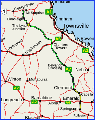
The Gregory Highway is a state highway in Queensland, Australia that serves the major coal-mining centres of Central Queensland. The highway was named after Augustus Gregory, an early explorer.

The Bremer River is a river that is a tributary of the Brisbane River, located in the Scenic Rim and Brisbane regions of South East Queensland, Australia. The 100-kilometre (62 mi)-long Bremer River drains several Scenic Rim valleys in south-east Queensland, including the Fassifern Valley, with its catchment area covering approximately 2,032 square kilometres (785 sq mi). Most valleys within the catchment have extensive river terraces. The Bremer River system is extremely degraded.

The Kennedy Highway is a highway in northern Queensland, Australia. It runs as National Route 1 for approximately 243 km from Smithfield, on the northern outskirts of Cairns, to the Gulf Developmental Road in the vicinity of Forty Mile Scrub and Undara Volcanic national parks. South of this junction, the road continues as the Kennedy Developmental Road to Boulia about 936 kilometres away, via Hughenden. West of the junction, National Route 1 continues as the Gulf Developmental Road to Normanton.

The Coen River is a river in the Cape York Peninsula in Queensland, Australia.
The Pennefather River is a river located on the western Cape York Peninsula in Far North Queensland, Australia.

The Jardine River, formally known as Deception River, is the largest river of the Cape York Peninsula in Far North Queensland, Australia.

The Bohle River is a river in North Queensland, Australia.
The Nicholson River is a river in the Northern Territory and the state of Queensland, Australia.

The Gregory River is a river in the Northern Territory and the state of Queensland, Australia. The river is the largest perennial river in arid and semi-arid Queensland, one of the few permanently flowing rivers in the northwest of Queensland.

The Lynd River is a river located on the Cape York Peninsula in Far North Queensland, Australia.
The Ward River is a river in Far North Queensland, Australia.
The Haughton River is a river in North Queensland, Australia.
The Holroyd River is a river located on the Cape York Peninsula in Far North Queensland, Australia.
The Barratta Creek is a creek in North Queensland, Australia.
The Kendall River is a river in Far North Queensland, Australia.

The Lockhart River is a river in Queensland, Australia.
The Mcdonald River, also known as the Macdonald River and locally as the Collett River, is a river in Far North Queensland, Australia.
The Mission River is a river in Far North Queensland, Australia.
The Connors River is a river and anabranch in Central Queensland, Australia.
Ravensworth is a rural locality in the Shire of Mareeba, Queensland, Australia. In the 2016 census, Ravensworth had a population of 0 people.
