Cordalba

Last updated

Cordalba
Queensland
Commercial Hotel Cordalba.jpg
Commercial Hotel on Queen street, Cordalba
Australia Queensland location map.svg
Red pog.svg
Cordalba
Coordinates 25°09′31″S152°12′45″E / 25.1586°S 152.2125°E / -25.1586; 152.2125
Population467 (2021 census) [1]
 • Density31.34/km2 (81.2/sq mi)
Established1896
Postcode(s) 4660
Area14.9 km2 (5.8 sq mi)
Time zone AEST (UTC+10:00)
Location
LGA(s) Bundaberg Region
State electorate(s) Burnett
Federal division(s) Hinkler
Localities around Cordalba:
Promisedland Gregory River North Isis
Booyal Cordalba North Isis
Isis Central Isis Central Isis Central

Cordalba is a rural town and locality in the Bundaberg Region, Queensland, Australia. [2] [3] In the 2021 census, the locality of Cordalba had a population of 467 people. [1]

Contents

The town was founded in 1896 and played an important role in the sugar workers strike of 1911. [4]

Geography

The town is adjacent to the Isis Highway, 327 kilometres (203 mi) from the state capital, Brisbane and 42 kilometres (26 mi) south west of the regional centre of Bundaberg.

The Loggers Creek runs through the township which is situated next to the Cordalba State Forest. With rugged hills of open eucalypt woodland, this park is an adventurer's retreat. It protects several species such as possums and gliders which are nocturnal, and activities include many mountain biking and walking trails and birdwatching during the day. [5]

Climate

Cordalba has a subtropical climate with wet, hot summers and mild winters.

Culture and community

Typical of a small rural township, entertainment in Cordalba is centered on local school events [6] and social events at the Commercial Hotel. Cordalba State School is a co-educational school, located in township. The school has 85 students enrolled from Prep to Year Six, the Cordalba State School was established in 1894. [6]

It is typical for families to spend time in the 'Cordalba State Forest' and go for bike rides along the Joey Traill. [5] With rugged hills of open eucalypt woodland, this park is an adventurer's retreat. You can spotlight for possums and gliders at night and go mountain biking or birdwatching during the day. [5]

History

Workers gather at the Cordalba camp site near Maryborough during the Sugar Workers strike of 1911. Workers wanted an eight-hour day and higher wages. Tents appear in the background. StateLibQld 1 40595 Workers gather for a meeting at Cordalba, Queensland, 1911.jpg
Workers gather at the Cordalba camp site near Maryborough during the Sugar Workers strike of 1911. Workers wanted an eight-hour day and higher wages. Tents appear in the background.

The original inhabitants of the area were the Kabi (or Kabi Kabi) tribe of aboriginal people living a traditional lifestyle focused on native foods of the area, and fishing in nearby streams, rivers and the sea. [7] Their legacy can be seen in the name "Cordalba" meaning "place of the koalas".

Isis River Provisional School opened in 1881. In 1893 it was renamed Abingdon Provisional School. On 22 January 1894 it was renamed Cordalba Provisional School. On 24 January 1901 it became Cordalba State School. [8]

In 1895, Charles Holmes built the original Cordalba Hotel.[ citation needed ]

Cordalba Hotel with owner/builder Charles Holmes standing out front with his youngest daughter, and 3 older daughters on the upstairs verandah Cordalba Hotel 1895 built by Charles Holmes.jpg
Cordalba Hotel with owner/builder Charles Holmes standing out front with his youngest daughter, and 3 older daughters on the upstairs verandah

In the colonial period the great impetus for growth in local agriculture came with the arrival of the railway line in Cordalba in 1896 from the main Childers line. The township functioned as the main Queensland Railways depot and interchange station between 1896 and 1964, an old railway goods shed being a reminder of those days. [7]

Cordalba Post Office opened on 25 November 1896 (a receiving office had been open from 1893) and closed in 1981. [9]

St Saviour's Anglican Church was dedicated on 13 March 1898 by Bishop William Webber. It closed circa 1988. [10]

The town used to be in the Shire of Isis.[ when? ]

The commercial Hotel is famous for its former proprietress Maude Sheehan. Much like the Young & Jackson's Hotel in Melbourne and its famous nude artwork "Chloe", the Commercial Hotel in Cordalba also has a nude painting hanging over the public bar. When fully clothed, the model, Maude Sheehan, [11] once actually ran the place. Maude was amply built and famous for her fiery red hair, which matched an easily aroused temper. Legend has it that on one occasion Maude kicked off a troublemaker, who returned the following day, this time riding his horse into the bar. Incensed at the intrusion, Maude punched the horse between the eyes, bringing both horse and rider to the floor. Maude's nude portrait hangs alongside a rare early Marilyn Monroe poster which was retrieved from the town's rubbish dump. [11]

In the 1970s, Cordalba had seven pubs, prior to a 'spate of bad luck' with fire. [11]

Demographics

In the 2016 census, the locality of Cordalba had a population of 445 people. [12]

In the 2021 census, the locality of Cordalba had a population of 467 people. [1]

Education

Cordalba State School Cordalba State School, 2024.jpg
Cordalba State School

Cordalba State School is a government primary (Prep-6) school for boys and girls at Cemetery Road ( 25°09′31″S152°12′44″E / 25.1587°S 152.2121°E / -25.1587; 152.2121 (Cordalba State School) ). [13] [14] In 2017, the school had an enrolment of 69 students with 5 teachers (4 full-time equivalent) and 8 non-teaching staff (4 full-time equivalent). [15]

There are no secondary schools in Cordalba. The nearest government secondary school is Isis District State High School in Childers to the south-west. [16]

Attractions

See also

Related Research Articles

<span class="mw-page-title-main">Childers, Queensland</span> Town in Queensland, Australia

Childers is a rural town and locality in the Bundaberg Region, Queensland, Australia. In the 2021 census, the locality of Childers had a population of 1,682 people.

<span class="mw-page-title-main">Wallaville</span> Town in Queensland, Australia

Wallaville is a rural town and locality in the Bundaberg Region, Queensland, Australia. It is 372 kilometres (231 mi) north of the state capital, Brisbane and 43 kilometres (27 mi) south west of the regional centre of Bundaberg. In the 2021 census, the locality of Wallaville had a population of 363 people.

Buxton is a rural locality in the Bundaberg Region, Queensland, Australia. In the 2021 census, the locality of Buxton had a population of 507 people.

<span class="mw-page-title-main">Woodgate, Queensland</span> Suburb of Bundaberg Region, Queensland, Australia

Woodgate is a coastal locality in the Bundaberg Region, Queensland, Australia. In the 2021 census, Woodgate had a population of 1,521 people.

<span class="mw-page-title-main">Isis railway line</span> Former railway line in Queensland

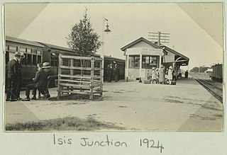
The Isis Branch Railway Line was a narrow gauge railway line in the present-day Bundaberg Region and North Burnett Region, Queensland, Australia. It connected Isis Junction on the North Coast railway line with the town of Dallarnil via the town of Childers and Cordalba. The line opened to Childers in 1887, to Cordabla in 1896, and to Dallarnil in 1909. The third section from Cordalba to Dallarnil closed in 1955 and the first two sections to Childers closed in 1964.

<span class="mw-page-title-main">Curra, Queensland</span> Suburb of Gympie Region, Queensland, Australia

Curra is a rural residential locality in the Gympie Region, Queensland, Australia. In the 2021 census, Curra had a population of 2,104 people.

<span class="mw-page-title-main">Apple Tree Creek, Queensland</span> Town in Queensland, Australia

Apple Tree Creek is a rural town and locality in the Bundaberg Region, Queensland, Australia. It was formerly known as Bodalla, the Dundaburra people of the Northern Kabi group name from the Gregory River Plum which to first Europeans looked like an apple. Prior to settlement of the Isis District which includes Apple tree Creek, the area was called Buth'arth translating to scrub. The town was renamed as Apple Tree Creek in 1962. In the 2021 census, the locality of Apple Tree Creek had a population of 726 people.

<span class="mw-page-title-main">South Kolan</span> Town in Queensland, Australia

South Kolan is a rural locality in the Bundaberg Region, Queensland, Australia. In the 2021 census, the locality of South Kolan had a population of 1,258 people.

South Bingera is a rural residential locality in the Bundaberg Region, Queensland, Australia. In the 2021 census, South Bingera had a population of 674 people.

Horton is a rural town and locality in the Bundaberg Region, Queensland, Australia. In the 2021 census, the locality of Horton had a population of 205 people.

North Isis is a rural locality in the Bundaberg Region, Queensland, Australia. In the 2021 census, North Isis had a population of 566 people.

<span class="mw-page-title-main">Woongarra, Queensland</span> Suburb of Bundaberg, Queensland, Australia

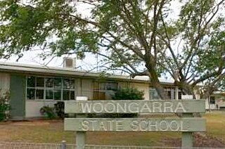
Woongarra is a rural locality in the Bundaberg Region, Queensland, Australia. In the 2021 census, Woongarra had a population of 585 people.

Drinan is a rural locality in the Bundaberg Region, Queensland, Australia. In the 2021 census, Drinan had a population of 135 people.

Pine Creek is a rural locality in the Bundaberg Region, Queensland, Australia. In the 2021 census, Pine Creek had a population of 258 people.

Duingal is a locality in the Bundaberg Region, Queensland, Australia. In the 2021 census, Duingal had a population of 70 people.

<span class="mw-page-title-main">Isis Central, Queensland</span> Suburb of Bundaberg Region, Queensland, Australia

Isis Central is a rural locality in the Bundaberg Region, Queensland, Australia. In the 2021 census, Isis Central had a population of 205 people.

<span class="mw-page-title-main">Miara, Queensland</span> Town in Queensland, Australia

Miara is a rural town and coastal locality in the Bundaberg Region, Queensland, Australia. In the 2021 census, the locality of Miara had a population of 28 people.

Eureka is a rural locality in the Bundaberg Region, Queensland, Australia. In the 2021 census, Eureka had a population of 223 people.

Kullogum is a rural locality in the Bundaberg Region, Queensland, Australia. In the 2021 census, Kullogum had a population of 120 people.

Gregory River is a rural locality in the Bundaberg Region, Queensland, Australia. In the 2021 census, Gregory River had a population of 65 people.

References

  1. 1 2 3 Australian Bureau of Statistics (28 June 2022). "Cordalba (SAL)". 2021 Census QuickStats. Retrieved 28 February 2023. OOjs UI icon edit-ltr-progressive.svg
  2. "Cordalba – town in Bundaberg Region (entry 8424)". Queensland Place Names. Queensland Government . Retrieved 4 November 2019.
  3. "Cordalba – locality in Bundaberg Region (entry 44704)". Queensland Place Names. Queensland Government . Retrieved 4 November 2019.
  4. John Oxley Library, State Library of Queensland.
  5. 1 2 3 "Cordalba State Forest (Department of National Parks, Sport and Racing)". Nprsr.qld.gov.au. 20 June 2013. Retrieved 29 September 2015.
  6. 1 2 "Cordalba State School". Cordalbass.eq.edu.au. Retrieved 29 September 2015.
  7. 1 2 "Childers | Bundaberg Regional Council". Bundaberg.qld.gov.au. Archived from the original on 1 October 2015. Retrieved 29 September 2015.
  8. Queensland Family History Society (2010), Queensland schools past and present (Version 1.01 ed.), Queensland Family History Society, ISBN   978-1-921171-26-0
  9. Premier Postal History. "Post Office List". Premier Postal Auctions. Retrieved 10 May 2014.
  10. "Closed Anglican Churches". Anglican Church South Queensland. Archived from the original on 3 April 2019. Retrieved 29 June 2020.
  11. 1 2 3 "Cordalba". Bundabergregion.org. Retrieved 29 September 2015.
  12. Australian Bureau of Statistics (27 June 2017). "Cordalba (SSC)". 2016 Census QuickStats. Retrieved 20 October 2018. OOjs UI icon edit-ltr-progressive.svg
  13. "State and non-state school details". Queensland Government. 9 July 2018. Archived from the original on 21 November 2018. Retrieved 21 November 2018.
  14. "Cordalba State School" . Retrieved 21 November 2018.
  15. "ACARA School Profile 2017". Archived from the original on 22 November 2018. Retrieved 22 November 2018.
  16. "Layers: Locality; Schools and school catchments". Queensland Globe. Queensland Government . Retrieved 25 December 2024.