Good Night, Queensland

Last updated

Good Night
Queensland
Australia Queensland location map.svg
Red pog.svg
Good Night
Coordinates 25°14′33″S151°53′57″E / 25.24260°S 151.89920°E / -25.24260; 151.89920 (Goodnight (centre of locality))
Population151 (2021 census) [1]
 • Density0.5938/km2 (1.538/sq mi)
Postcode(s) 4671
Area254.3 km2 (98.2 sq mi)
Time zone AEST (UTC+10:00)
Location
LGA(s)
State electorate(s) Callide
Federal division(s) Flynn
Suburbs around Good Night:
Doughboy St Agnes Morganville
Mount Perry Good Night Booyal
Mingo Wateranga
Coringa
Dallarnil

Good Night is a rural locality split between the Bundaberg Region and the North Burnett Region, Queensland, Australia. [2] [3] It is also written as Goodnight. In the 2021 census, Good Night had a population of 151 people. [1]

Contents

Geography

The Burnett River bounds the locality to the south-east and Kallina Creek to the south-west. [4]

The Goodnight Scrub National Park occupies most of the southern part of the locality, which is accessed from Booyal on the Bruce Highway via a low-level bridge over the Burnett River. [5]

There is some rural residential development in the east of the locality and some crop growing in the north. Apart from these the predominant land use is grazing on native vegetation. [4]

History

Goodnight Scrub State School opened on 28 January 1919 and closed on 1942. [6] A 1942 map suggests it was on Goodnight Scrub Road at approx 25°12′09″S151°58′08″E / 25.2025°S 151.9690°E / -25.2025; 151.9690 (Goodnight Scrub State School) in present-day Morganville. [7]

Demographics

In the 2016 census, Good Night had a population of 117 people. [8]

In the 2021 census, Good Night had a population of 151 people. [1]

Education

There are no schools in Good Night. The nearest primary schools are Booyal State School in neighbouring Booyal to the east and Wallaville State School in Wallaville to the north-east. The nearest secondary school is Gin Gin State High School in Gin Gin to the north-east. [4]

Amenities

The Goodnight Scrub Hall is at 333 Goodnight Scrub Road ( 25°12′42″S151°58′09″E / 25.21156°S 151.96907°E / -25.21156; 151.96907 (Goodnight Scrub Hall) ), now in Morganville. [9]

Related Research Articles

Goodnight Scrub is a national park in Queensland, Australia, 274 km northwest of Brisbane. It is located in the locality of Good Night which is split between the Bundaberg Region and the North Burnett Region local government areas, but is predominantly in the Bundaberg Region part of the locality. The park covers an area of 66.7 square kilometres (25.8 sq mi) of land within the Burnett River water catchment and the South East Queensland bioregions. At the southern extent of the park is the Paradise Dam.

<span class="mw-page-title-main">Gin Gin, Queensland</span> Town in Queensland, Australia

Gin Gin is a rural town and locality in the Bundaberg Region, Queensland, Australia. In the 2021 census, the locality of Gin Gin had a population of 1,139 people.

<span class="mw-page-title-main">Mount Perry, Queensland</span> Town in Queensland, Australia

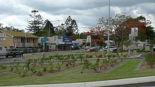
Mount Perry is a rural town and locality in the North Burnett Region, Queensland, Australia. In the 2016 census, the locality of Mount Perry had a population of 538 people.

<span class="mw-page-title-main">Shire of Kolan</span> Local government area in Queensland, Australia

The Shire of Kolan was a local government area located in the Wide Bay–Burnett region of Queensland, Australia, to the west of Bundaberg. The Shire, administered from the town of Gin Gin, covered an area of 2,650.6 square kilometres (1,023.4 sq mi), and existed as a local government entity from 1879 until 2008, when it was amalgamated with the City of Bundaberg and the Shires of Burnett and Isis to form the Bundaberg Region.

St Kilda is a rural locality in the Bundaberg Region, Queensland, Australia. In the 2016 census, St Kilda had a population of 90 people.

<span class="mw-page-title-main">Wallaville</span> Town in Queensland, Australia

Wallaville is a rural town and locality in the Bundaberg Region, Queensland, Australia. It is 372 kilometres (231 mi) north of the state capital, Brisbane and 43 kilometres (27 mi) south west of the regional centre of Bundaberg. In the 2016 census, Wallaville had a population of 410 people.

Bullyard is a small rural town and locality in Bundaberg Region, Queensland, Australia. In 2016 census, Bullyard had a population of 189 people.

The Wallaville Branch Railway was a fifty kilometre railway line in Queensland, Australia. It was a branch line from Goondoon railway station southwest to Kalliwa Creek. It was approved in December 1914 to tap the Goodnight Scrub forests and to transport sugar cane to the Wallaville mill established in 1896.

<span class="mw-page-title-main">Rosedale, Queensland</span> Town in Queensland, Australia

Rosedale is a rural town and locality split between the Gladstone Region and the Bundaberg Region in central Queensland, Australia. In the 2016 census, the locality of Rosedale had a population of 438 people.

<span class="mw-page-title-main">South Kolan</span> Town in Queensland, Australia

South Kolan is a rural locality in the Bundaberg Region, Queensland, Australia. In the 2021 census, South Kolan had a population of 1,258 people.

Oakwood is a rural locality in the Bundaberg Region, Queensland, Australia. In the 2016 census, Oakwood had a population of 331 people.

Sharon is a rural locality in the Bundaberg Region, Queensland, Australia. In the 2016 census, Sharon had a population of 1,316 people.

Booyal is a town and a locality in the Bundaberg Region, Queensland, Australia. In the 2016 census, Booyal had a population of 275 people.

Cynthia is a rural town and locality in the North Burnett Region, Queensland, Australia. In the 2016 census, Cynthia had a population of 31 people.

<span class="mw-page-title-main">Kalpowar</span> Town in Queensland, Australia

Kalpowar is a town in the North Burnett Region and a locality split between the North Burnett Region and the Bundaberg Region, in Queensland, Australia. In the 2016 census, the locality of Kalpowar had a population of 67 people.

Bungadoo is a rural locality in the Bundaberg Region, Queensland, Australia. The area was formerly known as Albionville. In the 2021 census, Bungadoo had a population of 342 people.

Morganville is a rural locality in the Bundaberg Region, Queensland, Australia.

Monal is a locality in the North Burnett Region, Queensland, Australia. In the 2021 census, Monal had a population of 34 people.

Dalysford is a rural locality in the Bundaberg Region, Queensland, Australia. In the 2021 census, Dalysford had a population of 136 people.

Lake Monduran is a rural locality in the Bundaberg Region, Queensland, Australia. In the 2021 census, Lake Monduran had "no people or a very low population".

References

  1. 1 2 3 Australian Bureau of Statistics (28 June 2022). "Good Night (SAL)". 2021 Census QuickStats. Retrieved 28 February 2023. OOjs UI icon edit-ltr-progressive.svg
  2. "Good Night – locality in Bundaberg Region (entry 44723)". Queensland Place Names. Queensland Government . Retrieved 28 December 2017.
  3. "Good Night – locality in North Burnett Region (entry 45354)". Queensland Place Names. Queensland Government . Retrieved 30 December 2017.
  4. 1 2 3 "Queensland Globe". State of Queensland . Retrieved 31 October 2020.
  5. Google (13 August 2019). "Good Night, Queensland" (Map). Google Maps . Google. Retrieved 13 August 2019.
  6. Queensland Family History Society (2010), Queensland schools past and present (Version 1.01 ed.), Queensland Family History Society, ISBN   978-1-921171-26-0
  7. "Wolca" (Map). Queensland Government. 1942. Archived from the original on 31 October 2020. Retrieved 31 October 2020.
  8. Australian Bureau of Statistics (27 June 2017). "Good Night (SSC)". 2016 Census QuickStats. Retrieved 20 October 2018. OOjs UI icon edit-ltr-progressive.svg
  9. "Venues for hire". Bundaberg Regional Council . Archived from the original on 26 November 2020. Retrieved 22 January 2021.