Gooroolba

Last updated

Gooroolba
Queensland
GooroolbaWarMemorial.JPG
War memorial
Australia Queensland location map.svg
Red pog.svg
Gooroolba
Coordinates 25°30′59″S151°48′29″E / 25.5163°S 151.8080°E / -25.5163; 151.8080 (Gooroolba (centre of locality))
Population21 (2021 census) [1]
 • Density0.671/km2 (1.74/sq mi)
Postcode(s) 4625
Area31.3 km2 (12.1 sq mi)
Time zone AEST (UTC+10:00)
Location
LGA(s) North Burnett Region
State electorate(s) Callide
Federal division(s) Flynn
Localities around Gooroolba:
Wetheron Mount Steadman Didcot
Byrnestown Gooroolba Didcot
Ginoondan Ginoondan Wilson Valley

Gooroolba is a rural locality in the North Burnett Region, Queensland, Australia. [2] In the 2021 census, the locality of Gooroolba had a population of 21 people. [1]

Contents

Geography

Gooroolba is in the Wide Bay–Burnett region 326 kilometres (203 mi) north of the state capital Brisbane.

History

The town's name is an abbreviation of the parish name of Gooroolballin, in turn named after the "Gooroolballan" sheep station. [3] Gooroolballan station was established by at least 1857. [4]

The extension of the Degilbo to Wetheron in 1906 brought the railway to Gooroolba. [5] A tender was let for construction of a state school in the town in 1910. [6]

Gooroolba Post Office opened by June 1910 (a receiving office had been open from 1907) and closed in 1973. [7]

Gooroolba State School opened on 18 April 1911. It closed in 1964. [8] [9] [10]

Mingo Crossing Provisional School opened circa July 1913 and was renamed Fleetwood Provisional School later that year. Allawah Provisional School opened on 7 July 1913. The two schools operated as half-time schools, sharing a single teacher between them. Fleetwood Provisional School closed circa 1915 with Allawah Provisional School becoming a full-time school until it closed in 1917. [10]

In 1917, a cyclone caused significant damage to the town, destroying the public hall and partially wrecking the hotel and two private stores. [11]

The Gooroolba War Memorial is located near the railway crossing. Originally erected to commemorate those who served in World War I, the names of those who served in World War II were added later. [12]

Demographics

In the 2016 census, the locality of Gooroolba had a population of 12 people. [13]

In the 2021 census, the locality of Gooroolba had a population of 21 people. [1]

Related Research Articles

<span class="mw-page-title-main">Gayndah</span> Town in Queensland, Australia

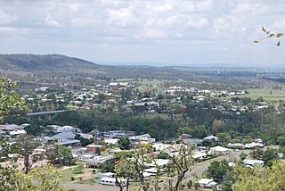
Gayndah is a town and locality in the North Burnett Region, Queensland, Australia. It is the administrative centre for the North Burnett Region. In the 2021 census, the locality of Gayndah had a population of 1,949 people.

<span class="mw-page-title-main">Biggenden</span> Town in Queensland, Australia

Biggenden is a rural town and locality in the North Burnett Region, Queensland, Australia. In the 2021 census, the locality of Biggenden had a population of 788 people.

<span class="mw-page-title-main">Shire of Gayndah</span> Local government area in Queensland, Australia

The Shire of Gayndah was a local government area located in the northern catchment of the Burnett River, Queensland, Australia. The shire covered an area of 2,709.3 square kilometres (1,046.1 sq mi), and existed as a local government area from 1866 until 2008, when it amalgamated with several other shires to form the North Burnett Region.

<span class="mw-page-title-main">Mungar Junction to Monto railway line</span> Former railway line in Queensland, Australia

The Mungar Junction to Monto railway line is a 267-kilometre (166 mi) railway in Queensland, Australia. Progressively opened in eleven stages between 1889 and 1928 the line branched from the North Coast line at Mungar Junction a short distance west of Maryborough and followed a westerly route towards Biggenden and Gayndah before turning north via Mundubbera and Eidsvold to Monto. It is also known as the Gayndah Monto Branch Railway. In 2012, the line was officially closed.

<span class="mw-page-title-main">Degilbo</span> Town in Queensland, Australia

Degilbo is a rural town and locality in the North Burnett Region, Queensland, Australia. In the 2016 census, the locality of Degilbo had a population of 174 people.

<span class="mw-page-title-main">Ideraway</span> Town in Queensland, Australia

Ideraway is a rural town and locality in the North Burnett Region, Queensland, Australia. In the 2016 census, the locality of Ideraway had a population of 38 people.

Byrnestown is a rural locality in the North Burnett Region, Queensland, Australia. The town was established as one of the first communes in Queensland. In the 2021 census, Byrnestown had a population of 27 people.

<span class="mw-page-title-main">Didcot, Queensland</span> Suburb of North Burnett Region, Queensland, Australia

Didcot is a rural locality in the North Burnett Region, Queensland, Australia. In the 2021 census, Didcot had a population of 85 people.

<span class="mw-page-title-main">Deep Creek Railway Bridge</span> Historic site in Queensland, Australia

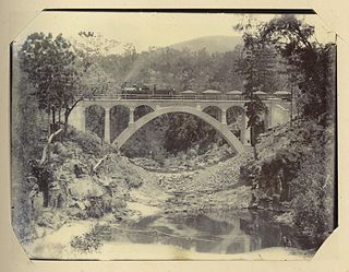
Deep Creek Railway Bridge is also known as Chowey Bridge. It is a heritage-listed railway bridge on the Mungar-Monto railway line in Didcot, North Burnett Region, Queensland, Australia. It was built in 1905 by day labour. It was added to the Queensland Heritage Register on 21 October 1992.

Wetheron is a rural town and locality in the North Burnett Region, Queensland, Australia. In the 2016 census, Wetheron had a population of 46 people.

<span class="mw-page-title-main">Humphery Railway Bridge</span> Historic site in Queensland, Australia

Humphery Railway Bridge is a heritage-listed railway bridge on the Mungar to Monto railway line at Humphery, North Burnett Region, Queensland, Australia. It was designed by William Pagan and built in 1913. It was added to the Queensland Heritage Register on 21 October 1992.

<span class="mw-page-title-main">Binjour</span> Suburb of North Burnett Region, Queensland, Australia

Binjour is a rural locality in the North Burnett Region, Queensland, Australia. In the 2021 census, Binjour had a population of 86 people.

Gurgeena is a rural locality in the North Burnett Region, Queensland, Australia. In the 2021 census, Gurgeena had a population of 36 people.

Mount Steadman is a rural locality in the North Burnett Region, Queensland, Australia. In the 2021 census, Mount Steadman had "no people or a very low population".

<span class="mw-page-title-main">Mount Debateable, Queensland</span> Suburb of North Burnett Region, Queensland, Australia

Mount Debateable is a rural locality in the North Burnett Region, Queensland, Australia. In the 2021 census, Mount Debateable had a population of 40 people.

Bon Accord is a rural locality in the North Burnett Region, Queensland, Australia. In the 2021 census, Bon Accord had a population of 29 people.

Barlyne is a locality in the North Burnett Region, Queensland, Australia. In the 2021 census, Barlyne had "no people or a very low population".

Dirnbir is a rural locality in the North Burnett Region, Queensland, Australia. In the 2021 census, Dirnbir had a population of 59 people.

Mount Lawless is a rural locality in the North Burnett Region, Queensland, Australia. In the 2021 census, Mount Lawless had a population of 9 people.

Wilson Valley is a rural locality in the North Burnett Region, Queensland, Australia. In the 2021 census, Wilson Valley had a population of 20 people.

References

  1. 1 2 3 Australian Bureau of Statistics (28 June 2022). "Gooroolba (SAL)". 2021 Census QuickStats. Retrieved 28 February 2023. OOjs UI icon edit-ltr-progressive.svg
  2. "Gooroolba – locality in North Burnett Region (entry 45356)". Queensland Place Names. Queensland Government . Retrieved 28 December 2020.
  3. "SKETCHER". The Queenslander . National Library of Australia. 4 April 1914. p. 8. Archived from the original on 13 September 2021. Retrieved 14 January 2014.
  4. "Advertising". The Empire . Sydney: National Library of Australia. 15 January 1857. p. 7. Archived from the original on 13 June 2022. Retrieved 14 January 2014.
  5. "Degilbo to Wetheron Railway". The Brisbane Courier . National Library of Australia. 26 September 1906. p. 7. Archived from the original on 13 June 2022. Retrieved 14 January 2014.
  6. "Public Works". The Brisbane Courier . National Library of Australia. 1 October 1910. p. 14. Archived from the original on 13 June 2022. Retrieved 14 January 2014.
  7. Phoenix Auctions History. "Post Office List". Phoenix Auctions. Archived from the original on 13 June 2022. Retrieved 22 February 2021.
  8. "Opening and closing dates of Queensland Schools". Queensland Government . Retrieved 29 May 2014.
  9. "Agency ID 6252, Gooroolba State School". Queensland State Archives . Retrieved 30 May 2014.
  10. 1 2 Queensland Family History Society (2010), Queensland schools past and present (Version 1.01 ed.), Queensland Family History Society, ISBN   978-1-921171-26-0
  11. "GALE IN QUEENSLAND". The Advertiser . Adelaide: National Library of Australia. 25 September 1917. p. 4. Archived from the original on 13 June 2022. Retrieved 14 January 2014.
  12. "Gooroolba War Memorial". Monument Australia. Archived from the original on 7 April 2014. Retrieved 5 April 2014.
  13. Australian Bureau of Statistics (27 June 2017). "Gooroolba (SSC)". 2016 Census QuickStats. Retrieved 20 October 2018. OOjs UI icon edit-ltr-progressive.svg

Further reading

Commons-logo.svg Media related to Gooroolba, Queensland at Wikimedia Commons