Eidsvold East, Queensland

Last updated

Eidsvold East
Queensland
Australia Queensland location map.svg
Red pog.svg
Eidsvold East
Coordinates 25°19′24″S151°15′14″E / 25.3233°S 151.2538°E / -25.3233; 151.2538 (Eidsvold East (centre of locality))
Population27 (SAL 2021) [1]
Postcode(s) 4627
Area376.4 km2 (145.3 sq mi)
Time zone AEST (UTC+10:00)
Location
LGA(s) North Burnett Region
State electorate(s) Callide
Federal division(s) Flynn
Suburbs around Eidsvold East:
Cynthia
Ceratodus
Yarrol Mungy
Eidsvold Eidsvold East Branch Creek
Grosvenor Malmoe Cattle Creek

Eidsvold East is a rural locality in the North Burnett Region, Queensland, Australia. [2] In the 2021 census, Eidsvold East had a population of 27 people. [3]

Contents

Geography

As the name suggests, Eidsvold East is east of the town of Eidsvold. [4]

The Red Mountain is in the south-east of the locality ( 25°23′19″S151°16′38″E / 25.3885°S 151.2773°E / -25.3885; 151.2773 (The Red Mountain) ), rising to 364 metres (1,194 ft) above sea level. [5] [6]

The Dalgangal State Forest is a protected area in the north-west of the locality. Apart from it, the land use is almost entirely grazing on native vegetation. [4]

History

The name Eidsvold is the name of the pastoral run operated in 1847-48 by Thomas Archer and David Archer, using the name of the town in Norway where Norwegian constitution was signed in 1814. [2] Although originally from Scotland, the Archer family immigrated to Norway prior to immigrating to Queensland. [7]

Demographics

In the 2016 census, Eidsvold East had a population of 20 people. [8]

In the 2021 census, Eidsvold East had a population of 27 people. [3]

Education

There are no schools in Eidsvold. The nearest government primary schools are Eidsvold State School in neighbouring Eidsvold to the west and Mundubbera State College in Mundubbera to the south. The nearest government secondary schools are Eidsvold State School (to Year 12) and Mundubbera State College (to Year 10). [4]

Related Research Articles

<span class="mw-page-title-main">Eidsvold, Queensland</span> Town in Queensland, Australia

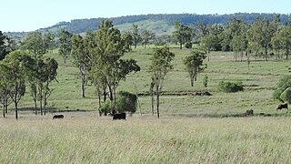
Eidsvold is a rural town and locality in the North Burnett Region, Queensland, Australia. The town is the self-proclaimed Beef Capital of the Burnett and is a hub for the regional cattle industry. In the 2016 census, the locality of Eidsvold had a population of 574 people.

<span class="mw-page-title-main">Shire of Mundubbera</span> Local government area in Queensland, Australia

The Shire of Mundubbera was a local government area in the northern catchment of the Burnett River, Queensland, Australia. The shire covered an area of 4,192.8 square kilometres (1,618.8 sq mi), and existed as a local government area from 1915 until 2008, when it amalgamated with several other shires to form the North Burnett Region.

<span class="mw-page-title-main">Shire of Monto</span> Local government area in Queensland, Australia

The Shire of Monto was a local government area in the northern catchment of the Burnett River, Queensland, Australia. The shire covered an area of 4,320.8 square kilometres (1,668.3 sq mi), and existed as a local government area from 1932 until 2008, when it amalgamated with several other shires to form the North Burnett Region.

<span class="mw-page-title-main">Shire of Eidsvold</span> Local government area in Queensland, Australia

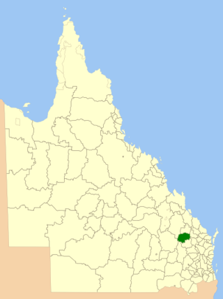
The Shire of Eidsvold was a local government area in the northern catchment of the Burnett River, Queensland, Australia. The shire covered an area of 4,809.4 square kilometres (1,856.9 sq mi), and existed as a local government area from 1890 until 2008, when it amalgamated with several other shires to form the North Burnett Region.

<span class="mw-page-title-main">Ironpot, Queensland (South Burnett Region)</span> Town in Queensland, Australia

Ironpot is a rural locality in the South Burnett Region, Queensland, Australia. In the 2016 census Ironpot had a population of 45 people.

<span class="mw-page-title-main">Didcot, Queensland</span> Suburb of North Burnett Region, Queensland, Australia

Didcot is a rural locality in the North Burnett Region, Queensland, Australia. In the 2016 census Didcot had a population of 60 people.

Cynthia is a rural town and locality in the North Burnett Region, Queensland, Australia. In the 2016 census, Cynthia had a population of 31 people.

Langley is a rural locality in the North Burnett Region, Queensland, Australia.

Monogorilby is a locality in the North Burnett Region, Queensland, Australia. The neighbourhood of Allies Creek is located in the south-east of Monogorilby.

Beeron is a rural locality in the North Burnett Region, Queensland, Australia. In the 2016 census Beeron had a population of 14 people.

Derri Derra is a rural locality in the North Burnett Region, Queensland, Australia. In the 2016 census Derri Derra had a population of 146 people.

Gurgeena is a rural locality in the North Burnett Region, Queensland, Australia. In the 2016 census, Gurgeena had a population of 35 people.

<span class="mw-page-title-main">Mundowran</span> Suburb of North Burnett Region, Queensland, Australia

Mundowran is a rural locality in the North Burnett Region, Queensland, Australia. In the 2016 census Mundowran had a population of 122 people.

Riverleigh is a rural locality in the North Burnett Region, Queensland, Australia. In the 2016 census, Riverleigh had a population of 80 people.

Boynewood is a locality in the North Burnett Region, Queensland, Australia. In the 2021 census, Boynewood had a population of 138 people.

Coonambula is a locality in the North Burnett Region, Queensland, Australia. In the 2016 census, Coonambula had a population of 70 people.

Deep Creek is a rural locality in the North Burnett Region, Queensland, Australia. In the 2016 census, Deep Creek had a population of 16 people.

Dirnbir is a rural locality in the North Burnett Region, Queensland, Australia. In the 2021 census, Dirnbir had a population of 59 people.

Branch Creek is a locality in the North Burnett Region, Queensland, Australia. In the 2021 census, Branch Creek had a population of 33 people.

Eidsvold West is a rural locality in the North Burnett Region, Queensland, Australia. In the 2021 census, Eidsvold West had a population of 85 people.

References

  1. Australian Bureau of Statistics (28 June 2022). "Eidsvold East (Suburb and Locality)". Australian Census 2021 QuickStats. Retrieved 28 June 2022.  OOjs UI icon edit-ltr-progressive.svg
  2. 1 2 "Eidsvold East – locality in North Burnett Region (entry 45347)". Queensland Place Names. Queensland Government . Retrieved 2 August 2019.
  3. 1 2 Australian Bureau of Statistics (28 June 2022). "Eidsvold East (SAL)". 2021 Census QuickStats. Retrieved 28 February 2023. OOjs UI icon edit-ltr-progressive.svg
  4. 1 2 3 "Queensland Globe". State of Queensland . Retrieved 5 September 2023.
  5. "Mountain peaks and capes - Queensland". Queensland Open Data. Queensland Government. 12 November 2020. Archived from the original on 25 November 2020. Retrieved 25 November 2020.
  6. "The Red Mountain – mountain in North Burnett Region (entry 34087)". Queensland Place Names. Queensland Government . Retrieved 25 November 2020.
  7. O'Keeffe, Mary, "Archer, David (1816–1900)", Australian Dictionary of Biography, National Centre of Biography, Australian National University, retrieved 5 September 2023
  8. Australian Bureau of Statistics (27 June 2017). "Eidsvold East (SSC)". 2016 Census QuickStats. Retrieved 20 October 2018. OOjs UI icon edit-ltr-progressive.svg