Harrami

Last updated

Harrami
Queensland
Australia Queensland location map.svg
Red pog.svg
Harrami
Coordinates 24°46′54″S150°41′44″E / 24.7816°S 150.6955°E / -24.7816; 150.6955 (Harrami (centre of locality))
Population22 (2021 census) [1]
 • Density0.0700/km2 (0.181/sq mi)
Postcode(s) 4630
Area314.4 km2 (121.4 sq mi)
Time zone AEST (UTC+10:00)
Location
LGA(s) North Burnett Region
State electorate(s) Callide
Federal division(s) Flynn
Suburbs around Harrami:
Thangool Lawgi Dawes Lawgi Dawes
Camboon Harrami Coominglah
Rawbelle Rawbelle Rawbelle

Harrami is a rural locality in the North Burnett Region, Queensland, Australia. [2] In the 2021 census, Harrami had a population of 22 people. [1]

Contents

Geography

The locality is bounded to the north by the Dawes Range. The land use is almost entirely grazing on native vegetation. [3]

The locality contains the following mountains:

Rawbelle River rises in the north-east of the locality and exits to the south (Rawbelle), where it becomes a tributary of the Nogo River, part of the Burnett River basin which ultimately flows into the Coral Sea. [3]

History

Harrami Provisional School opened on 7 July 1941 but it closed in 1945. It opened again on 15 September 1947 and in 1948 became Harrami State School. It closed permanently on 20 March 1966. [7] It was at 1546 Harrami Road ( 24°45′44″S150°38′22″E / 24.76211°S 150.63941°E / -24.76211; 150.63941 (Harrami State School (former)) ). [8]

The Harrami hall of the Queensland Country Women's Association was officially opened on Sunday 30 March 1952. [9] It was on the eastern side of Harrami Road (approx 24°45′34″S150°38′22″E / 24.7595°S 150.6395°E / -24.7595; 150.6395 (Harrami CWA (former)) ). [10]

Demographics

In the 2016 census, Harrami had a population of 39 people. [11]

In the 2021 census, Harrami had a population of 22 people. [1]

Education

There are no schools in Harrami. The nearest government primary school is Thangool State School in neighbouring Thangool to the north-west. The nearest government secondary schools are Biloela State High School in Biloela to the north and Monto State High School in Monto to the east. [3]

Related Research Articles

<span class="mw-page-title-main">Burnett Highway</span> Highway in Queensland, Australia

The Burnett Highway is an inland rural highway located in Queensland, Australia. The highway runs from its junction with the Bruce Highway at Gracemere, just south of Rockhampton, to the D'Aguilar Highway in Nanango. Its length is approximately 542 kilometres. The highway takes its name from the Burnett River, which it crosses in Gayndah. The Burnett Highway provides the most direct link between the northern end of the New England Highway and Rockhampton. It is designated as a State Strategic Road by the Queensland Government.

<span class="mw-page-title-main">Shire of Monto</span> Local government area in Queensland, Australia

The Shire of Monto was a local government area in the northern catchment of the Burnett River, Queensland, Australia. The shire covered an area of 4,320.8 square kilometres (1,668.3 sq mi), and existed as a local government area from 1932 until 2008, when it amalgamated with several other shires to form the North Burnett Region.

<span class="mw-page-title-main">Thangool</span> Town in Queensland, Australia

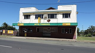
Thangool is a rural town and locality in the Shire of Banana, Queensland, Australia. In the 2016 census, the locality of Thangool had a population of 741 people.

Camboon is a rural locality in the Shire of Banana, Queensland, Australia. In the 2021 census, Camboon had a population of 76 people.

<span class="mw-page-title-main">Didcot, Queensland</span> Suburb of North Burnett Region, Queensland, Australia

Didcot is a rural locality in the North Burnett Region, Queensland, Australia. In the 2021 census, Didcot had a population of 85 people.

Humphery is a rural locality in the North Burnett Region, Queensland, Australia. In the 2021 census, Humphery had a population of 24 people.

<span class="mw-page-title-main">Kalpowar</span> Town in Queensland, Australia

Kalpowar is a town in the North Burnett Region and a locality split between the North Burnett Region and the Bundaberg Region, in Queensland, Australia. In the 2016 census, the locality of Kalpowar had a population of 67 people.

Kapaldo is a rural town and locality in the North Burnett Region, Queensland, Australia. In the 2016 census, the locality of Kapaldo had a population of 43 people.

Lakeside is a rural locality in the North Burnett Region, Queensland, Australia. In the 2021 census, Lakeside had a population of 69 people.

<span class="mw-page-title-main">Mungungo</span> Town in Queensland, Australia

Mungungo is a rural town and locality in the North Burnett Region, Queensland, Australia. In the 2016 census, the locality of Mungungo had a population of 77 people.

<span class="mw-page-title-main">Valentine Plains</span> Suburb of Shire of Banana, Queensland, Australia

Valentine Plains is a rural locality in the Shire of Banana, Queensland, Australia. In the 2021 census, Valentine Plains had a population of 373 people.

<span class="mw-page-title-main">Lawgi Dawes</span> Suburb of Shire of Banana, Queensland, Australia

Lawgi Dawes is a rural locality in the Shire of Banana, Queensland, Australia. It contains the neighbourhood of Lawgi, a former town.

Dakenba is a rural locality in the Shire of Banana, Queensland, Australia. In the 2021 census, Dakenba had a population of 127 people.

Monal is a locality in the North Burnett Region, Queensland, Australia. In the 2021 census, Monal had a population of 34 people.

<span class="mw-page-title-main">Rawbelle, Queensland</span> Suburb of North Burnett Region, Queensland, Australia

Rawbelle is a locality in the North Burnett Region, Queensland, Australia. In the 2021 census, Rawbelle had a population of 51 people.

<span class="mw-page-title-main">Coominglah, Queensland</span> Suburb of North Burnett Region, Queensland, Australia

Coominglah is a rural locality in the North Burnett Region, Queensland, Australia. The land use is grazing on native vegetation.

Selene is a rural locality in the North Burnett Region, Queensland, Australia. In the 2016 census Selene had a population of 25 people.

Mount Lawless is a rural locality in the North Burnett Region, Queensland, Australia. In the 2021 census, Mount Lawless had a population of 9 people.

Orange Creek is a rural locality in the Shire of Banana, Queensland, Australia. In the 2021 census, Orange Creek had a population of 197 people.

<span class="mw-page-title-main">Mount Alma, Queensland</span> Suburb of Gladstone Region, Queensland, Australia

Mount Alma is a rural locality in the Gladstone Region, Queensland, Australia. In the 2021 census, Mount Alma had a population of 59 people.

References

  1. 1 2 3 Australian Bureau of Statistics (28 June 2022). "Harrami (SAL)". 2021 Census QuickStats. Retrieved 28 February 2023. OOjs UI icon edit-ltr-progressive.svg
  2. "Harrami – locality in North Burnett Region (entry 45361)". Queensland Place Names. Queensland Government . Retrieved 28 December 2020.
  3. 1 2 3 "Queensland Globe". State of Queensland . Retrieved 25 February 2023.
  4. 1 2 "Mountain peaks and capes - Queensland". Queensland Open Data. Queensland Government. 12 November 2020. Archived from the original on 25 November 2020. Retrieved 25 November 2020.
  5. "Mount Hindmarsh – mountain in North Burnett Region (entry 15920)". Queensland Place Names. Queensland Government . Retrieved 25 November 2020.
  6. "Mount Shaw – mountain in North Burnett Region (entry 30598)". Queensland Place Names. Queensland Government . Retrieved 25 November 2020.
  7. Queensland Family History Society (2010), Queensland schools past and present (Version 1.01 ed.), Queensland Family History Society, ISBN   978-1-921171-26-0
  8. "Queensland Two Mile series sheet 2m161" (Map). Queensland Government. 1949. Archived from the original on 25 February 2023. Retrieved 25 February 2023.
  9. "Monto". The Central Queensland Herald . Vol. 21, no. 1201. Queensland, Australia. 17 April 1952. p. 23. Retrieved 25 February 2023 via National Library of Australia.
  10. "9048-31 Harrami" (Map). Queensland Government. 1975. Archived from the original on 25 February 2023. Retrieved 25 February 2023.
  11. Australian Bureau of Statistics (27 June 2017). "Harrami (SSC)". 2016 Census QuickStats. Retrieved 28 May 2024. OOjs UI icon edit-ltr-progressive.svg

Further reading