Yarrol, Queensland

Last updated

Yarrol
Queensland
Australia Queensland location map.svg
Red pog.svg
Yarrol
Coordinates 25°01′09″S151°25′34″E / 25.0191°S 151.4261°E / -25.0191; 151.4261 (Yarrol (centre of locality))
Population15 (SAL 2021) [1]
Postcode(s) 4630
Area950.2 km2 (366.9 sq mi)
Time zone AEST (UTC+10:00)
LGA(s) North Burnett Region
State electorate(s) Callide
Federal division(s) Flynn
Suburbs around Yarrol:
Bancroft
Ventnor
Kalpowar
Molangul
Gaeta
Tellebang
Langley
Yarrol Wonbah Forest
Wonbah
Abercorn
Cynthia
Eidsvold East
Mungy
Mount Perry

Yarrol is a rural locality in the North Burnett Region, Queensland, Australia. [2] In the 2021 census, Yarrol had a population of 15 people. [3]

Contents

Geography

The Monto–Mount Perry Road enters the locality from the south-west (Langley) and exits to the south (Mungy). [4]

There are two named peaks in the north of the locality:

Most of the east of the locality is within the Bania National Park and the smaller Baywulla Creek Conservation Park. There are a number of areas of state forests, including the Yarrol State Forest in the north of the locality, the Bania State Forest in the centre and east of the locality, and the Baywulla State Forest in the south of the locality. Apart from these protected areas, the land use is grazing on native vegetation. [8]

History

Yarrol Road State School opened on 3 June 1946. In July 1948, it became Ventnor State School. It closed on 22 April 1960. [9] It was at 1877 Yarrol Road in neighbouring Ventnor ( 24°54′39″S151°17′11″E / 24.91078°S 151.28643°E / -24.91078; 151.28643 (Ventnor State School (former)) ). [10] [11] In 1963, local residents made an offer of £150 to purchase the school from the Department of Education and the property was transferred to the Ventnor Progress Association on 15 March 1963. Since that time, the school complex has been used as headquarters for the progress association, for religious group services, farming and pastoral bodies and fire control groups and was regularly used as a polling booth. The Ventnor Progress Association continues to own and maintain the premises In the 1992, the school buildings were listed on the Queensland Heritage Register. [12]

Funeral procession for the air crash victims in Bundaberg, 1948 Funeral procession for the Yarrol (near Monto) air crash victims in Bundaberg, 1948.jpg
Funeral procession for the air crash victims in Bundaberg, 1948

In June 1948, two stockmen found the charred wreckage of an aeroplane and human remains in a 200-foot (61 m) gully on Magpie Station at Yarro. Military equipment found at the crash site suggested it was a World War II military aircraft, which was confirmed by an investigation by the Royal Australian Air Force which determined it was a twin-engine Douglas aircraft used by the United States Army operating as a transport aircraft that had been reported missing on 1 November 1943 on a flight from Rockhampton to Brisbane with 12 people listed on the mainfest. An unsuccessful search had been conducted to find the missing aircraft after its disappearance. [13] [14] [15] [16] As the weather conditions on the day had been turbulent and the engines were found at some distance from the fusilage, it was determined the aircraft had broken up in mid-air. It was subsequently established that a 13th person was also onboard when a woman came forward claiming that her husband, an American serviceman, had been reported missing at the same time, suspecting he may have been on the flight; this was confirmed by finding his signet ring and identity disk at the wreck site. [17] Of the 13 victims, six were American, six were Australian, and one was from England. The human remains could not be individually identified, but were buried in Bundaberg War Cemetery (within Bundaberg General Cemetery) in a graveside funeral service conducted by local clergymen. The coffins were carried on trucks draped in flags with a military escort who acted as pallbearers at the cemtery. Businesses in Bundaberg were closed allowing thousands of people, despite the heavy rain, to line the streets to pay a final tribute to the dead. [18] [19] [20]

Demographics

In the 2016 census, Yarrol had a population of 8 people. [21]

In the 2021 census, Yarrol had a population of 15 people. [3]

Education

There are no schools in Yarrol. The nearest government primary schools are: [22]

The nearest governent secondary schools are Eidsvold State School and Monto State High School in Monto. [22]

Related Research Articles

<span class="mw-page-title-main">Eidsvold, Queensland</span> Town in Queensland, Australia

Eidsvold is a rural town and locality in the North Burnett Region, Queensland, Australia. The town is the self-proclaimed Beef Capital of the Burnett and is a hub for the regional cattle industry. In the 2016 census, the locality of Eidsvold had a population of 574 people.

<span class="mw-page-title-main">Mount Perry, Queensland</span> Town in Queensland, Australia

Mount Perry is a rural town and locality in the North Burnett Region, Queensland, Australia. In the 2016 census, the locality of Mount Perry had a population of 538 people.

<span class="mw-page-title-main">Monto, Queensland</span> Town in Queensland, Australia

Monto is a rural town and locality in the North Burnett Region, Queensland, Australia. In the 2021 census, the locality of Monto had a population of 1,156 people.

<span class="mw-page-title-main">Ceratodus, Queensland</span> Place in Queensland, Australia

Ceratodus is a rural town and locality in the North Burnett Region, Queensland, Australia. In the 2016 census the locality of Ceratodus had a population of 28 people.

<span class="mw-page-title-main">Mungar Junction to Monto railway line</span> Former railway line in Queensland, Australia

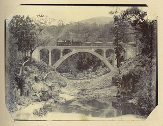
The Mungar Junction to Monto railway line is a 267-kilometre (166 mi) railway in Queensland, Australia. Progressively opened in eleven stages between 1889 and 1928 the line branched from the North Coast line at Mungar Junction a short distance west of Maryborough and followed a westerly route towards Biggenden and Gayndah before turning north via Mundubbera and Eidsvold to Monto. It is also known as the Gayndah Monto Branch Railway. In 2012, the line was officially closed.

<span class="mw-page-title-main">Abercorn, Queensland</span> Suburb of North Burnett Region, Queensland, Australia

Abercorn is a rural town and locality in the North Burnett Region, Queensland, Australia. In the 2016 census, the locality of Abercorn had a population of 46 people.

<span class="mw-page-title-main">Ventnor, Queensland</span> Suburb of North Burnett Region, Queensland, Australia

Ventnor is a rural locality in the North Burnett Region, Queensland, Australia. In the 2021 census, Ventnor had a population of 13 people.

Cynthia is a rural town and locality in the North Burnett Region, Queensland, Australia. In the 2016 census, Cynthia had a population of 31 people.

Langley is a rural locality in the North Burnett Region, Queensland, Australia.

O'Bil Bil is a rural locality in the North Burnett Region, Queensland, Australia. In the 2016 census O'Bil Bil had a population of 29 people.

<span class="mw-page-title-main">Kalpowar</span> Town in Queensland, Australia

Kalpowar is a town in the North Burnett Region and a locality split between the North Burnett Region and the Bundaberg Region, in Queensland, Australia. In the 2016 census, the locality of Kalpowar had a population of 67 people.

<span class="mw-page-title-main">Bancroft, Queensland</span> Suburb of North Burnett Region, Queensland, Australia

Bancroft is a rural locality in the North Burnett Region, Queensland, Australia. In the 2016 census, Bancroft had a population of 96 people.

Bukali is a rural locality in the North Burnett Region, Queensland, Australia. In the 2021 census, Bukali had a population of 57 people.

Cannindah is a rural locality in the North Burnett Region, Queensland, Australia. In the 2021 census, Cannindah had a population of 35 people.

Moonford is a rural town and locality in the North Burnett Region, Queensland, Australia. In the 2016 census, the locality of Moonford had a population of 160 people.

Riverleigh is a rural locality in the North Burnett Region, Queensland, Australia. In the 2016 census, Riverleigh had a population of 80 people.

<span class="mw-page-title-main">Mount Debateable, Queensland</span> Suburb of North Burnett Region, Queensland, Australia

Mount Debateable is a rural locality in the North Burnett Region, Queensland, Australia. In the 2021 census, Mount Debateable had a population of 40 people.

Grosvenor is a locality in the North Burnett Region, Queensland, Australia. In the 2021 census, Grosvenor had a population of 29 people.

Monal is a locality in the North Burnett Region, Queensland, Australia. In the 2021 census, Monal had a population of 34 people.

Selene is a rural locality in the North Burnett Region, Queensland, Australia. In the 2016 census Selene had a population of 25 people.

References

  1. Australian Bureau of Statistics (28 June 2022). "Yarrol (suburb and locality)". Australian Census 2021 QuickStats. Retrieved 28 June 2022.  OOjs UI icon edit-ltr-progressive.svg
  2. "Yarrol – locality in North Burnett Region (entry 45429)". Queensland Place Names. Queensland Government . Retrieved 2 August 2019.
  3. 1 2 Australian Bureau of Statistics (28 June 2022). "Yarrol (SAL)". 2021 Census QuickStats. Retrieved 28 February 2023. OOjs UI icon edit-ltr-progressive.svg
  4. "Layers: Locality; Road and rail". Queensland Globe. Queensland Government. Archived from the original on 19 December 2017. Retrieved 5 April 2024.
  5. 1 2 "Mountain peaks and capes - Queensland". Queensland Open Data. Queensland Government. 12 November 2020. Archived from the original on 25 November 2020. Retrieved 25 November 2020.
  6. "Mount Dalgaran – mountain in North Burnett Region (entry 9219)". Queensland Place Names. Queensland Government . Retrieved 25 November 2020.
  7. "Mount Goondicum – mountain in North Burnett Region (entry 14297)". Queensland Place Names. Queensland Government . Retrieved 25 November 2020.
  8. "Layers: Locality; Protected areas and forests; Land use". Queensland Globe. Queensland Government. Archived from the original on 19 December 2017. Retrieved 5 April 2024.
  9. Queensland Family History Society (2010), Queensland schools past and present (Version 1.01 ed.), Queensland Family History Society, ISBN   978-1-921171-26-0
  10. "Queensland Two Mile series sheet 2m158" (Map). Queensland Government. 1952. Retrieved 23 February 2024.
  11. "Layers: Locality; Land parcel". Queensland Globe. Queensland Government. Archived from the original on 19 December 2017. Retrieved 23 February 2024.
  12. "Ventnor State School (entry 600727)". Queensland Heritage Register . Queensland Heritage Council. Retrieved 1 August 2014.
  13. "WAR PLANE WRECk, BODIES: NEAR MONTO". The Courier-mail . No. 3612. Queensland, Australia. 23 June 1948. p. 1. Retrieved 6 April 2024 via National Library of Australia.
  14. "GRISLY FIND AT AIR WRECK". Maryborough Chronicle . No. 23, 826. Queensland, Australia. 24 June 1948. p. 5. Retrieved 6 April 2024 via National Library of Australia.
  15. "Wrecked Plane Identified". The Northern Miner . Queensland, Australia. 24 June 1948. p. 1. Retrieved 6 April 2024 via National Library of Australia.
  16. "Crashed 1943; 12 On Board". The Courier-mail . No. 3615. Queensland, Australia. 26 June 1948. p. 3. Retrieved 6 April 2024 via National Library of Australia.
  17. "Grim "Hunch" Proved". The Courier-mail . No. 3622. Queensland, Australia. 5 July 1948. p. 1. Retrieved 6 April 2024 via National Library of Australia.
  18. "Husband Was 13th Victim In Crash". The Central Queensland Herald . Vol. 18, no. 1007. Queensland, Australia. 8 July 1948. p. 11. Archived from the original on 6 April 2024. Retrieved 6 April 2024 via National Library of Australia.
  19. "Bundaberg At Standstill To Honour Air Victims". The Courier-mail . No. 3623. Queensland, Australia. 6 July 1948. p. 3. Archived from the original on 6 April 2024. Retrieved 6 April 2024 via National Library of Australia.
  20. Dunn, Peter. "Crash of a C-47 Dakota of the 374th Troop Carrier Group, in the Monto area, 65 miles west of Bundaberg on 21 November 1943". Australia @ War. Archived from the original on 4 October 2023. Retrieved 5 April 2024.
  21. Australian Bureau of Statistics (27 June 2017). "Yarrol (SSC)". 2016 Census QuickStats. Retrieved 20 October 2018. OOjs UI icon edit-ltr-progressive.svg
  22. 1 2 "Layers: Locality; Schools and school catchments". Queensland Globe. Queensland Government. Archived from the original on 19 December 2017. Retrieved 5 April 2024.