
Mulgildie is a rural town and locality in the North Burnett Region, Queensland, Australia. In the 2021 census, the locality of Mulgildie had a population of 147 people.

The Boyne Valley is a rural locality in Gladstone Region, Queensland, Australia. The locality contains four small towns: Nagoorin, Ubobo, Builyan, and Many Peaks. In the 2021 census, Boyne Valley had a population of 301 people.
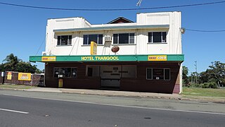
Thangool is a rural town and locality in the Shire of Banana, Queensland, Australia. In the 2021 census, the locality of Thangool had a population of 685 people.
Bracewell is a rural locality in the Gladstone Region, Queensland, Australia. In the 2021 census, Bracewell had a population of 178 people.

Didcot is a rural locality in the North Burnett Region, Queensland, Australia. In the 2021 census, Didcot had a population of 85 people.

Ventnor is a rural locality in the North Burnett Region, Queensland, Australia. In the 2021 census, Ventnor had a population of 13 people.
Humphery is a rural locality in the North Burnett Region, Queensland, Australia. In the 2021 census, Humphery had a population of 24 people.

Kalpowar is a town in the North Burnett Region and a locality split between the North Burnett Region and the Bundaberg Region, in Queensland, Australia. In the 2021 census, the locality of Kalpowar had a population of 53 people.

Bancroft is a rural locality in the North Burnett Region, Queensland, Australia. In the 2021 census, Bancroft had a population of 98 people.
Harrami is a rural locality in the North Burnett Region, Queensland, Australia. In the 2021 census, Harrami had a population of 22 people.
Kapaldo is a rural town and locality in the North Burnett Region, Queensland, Australia. In the 2021 census, the locality of Kapaldo had a population of 41 people.
Lakeside is a rural locality in the North Burnett Region, Queensland, Australia. In the 2021 census, Lakeside had a population of 69 people.
Riverleigh is a rural locality in the North Burnett Region, Queensland, Australia. In the 2021 census, Riverleigh had a population of 95 people.

Mungungo is a rural town and locality in the North Burnett Region, Queensland, Australia. In the 2021 census, the locality of Mungungo had a population of 84 people.

Lawgi Dawes is a rural locality in the Shire of Banana, Queensland, Australia. It contains the neighbourhood of Lawgi, a former town.

Cania is a locality in the North Burnett Region, Queensland, Australia. In the 2021 census, Cania had a population of 27 people.
Grosvenor is a locality in the North Burnett Region, Queensland, Australia. In the 2021 census, Grosvenor had a population of 29 people.
Monal is a locality in the North Burnett Region, Queensland, Australia. In the 2021 census, Monal had a population of 34 people.
Selene is a rural locality in the North Burnett Region, Queensland, Australia. In the 2021 census, Selene had a population of 27 people.
Mount Lawless is a rural locality in the North Burnett Region, Queensland, Australia. In the 2021 census, Mount Lawless had a population of 9 people.

