Gurgeena

Last updated

Gurgeena
Queensland
Australia Queensland location map.svg
Red pog.svg
Gurgeena
Coordinates 25°27′39″S151°23′49″E / 25.4608°S 151.3969°E / -25.4608; 151.3969 (Gurgeena (centre of locality))
Population35 (2016 census) [1]
 • Density1.051/km2 (2.72/sq mi)
Postcode(s) 4626
Area33.3 km2 (12.9 sq mi)
Time zone AEST (UTC+10:00)
Location
LGA(s) North Burnett Region
State electorate(s) Callide
Federal division(s) Flynn
Suburbs around Gurgeena:
Cattle Creek Branch Creek Branch Creek
Cattle Creek Gurgeena Branch Creek
Mundowran Philpott Binjour

Gurgeena is a rural locality in the North Burnett Region, Queensland, Australia. [2] In the 2016 census, Gurgeena had a population of 35 people. [1]

Contents

Geography

Gurgeena is on the Binjour Plateau ( 25°27′37″S151°23′58″E / 25.4602°S 151.3994°E / -25.4602; 151.3994 (Binjour Plateau) ). [3] Land use is principally agricultural and state forest. [4]

The Binjour Range Rest Area, at the top of the range, is near the southern end of the Binjour Plateau. [5] [6] Gurgeena is near the northern end of the plateau.

It is within the Burnett River drainage basin. [7]

History

In 1899 land from Boomerang and Buckingah Stations (parts of the Mt Debateable pastoral lease), and land that had been parts of Mundubbera (Mundowran) and Ideraway Stations comprised the Binjour Plateau. [8] These stations had been in existence for more than 50 years.

The Binjour Plateau was first surveyed by Mr R. W. Winks of the Department of Agriculture, Brisbane, surveying for the proposed Degilbo to Gayndah railway line extension. The purpose of the survey was to find land suitable for agriculture. Closer settlement would yield economic benefits for both the railway and the farmers. His report was laid before the Queensland Parliament on 16 November 1897. [9] At this time the plateau was unnamed. [10] Binjour Station and Reid's Creek were at the foot of the eastern edge of the plateau. Reid's Creek was also known as Binjour Creek. [11] [12] [13]

The plateau was named Mount Murray by the Hon. John Murray, Minister for Railways and Works, when he and others inspected the land in January 1899. [14] In 1899 Mr St John Wood, District-Surveyor, presented another survey specifically on Murray's Plateau to the Surveyor-General. [8] By 1906 the Brisbane Courier reported Murray Plateau "going back to original nomenclature. The name of Binjour, with its native associations, supplants that of Murray in defining the great plateau ... ." [15] At this time it was being opened up for selection as agricultural farms. [16]

Gurgeena State School opened on 7 November 1912 and closed in 1959. [17] The school was on Top Gurgeena Road ( 25°27′33″S151°23′55″E / 25.4593°S 151.3986°E / -25.4593; 151.3986 (Gurgeena State School (former)) ). [18] [7]

In the 2016 census, Gurgeena had a population of 35 people. [1]

Education

There are no schools in Gurgeena. The nearest government primary school is Binjour Plateau State School in neighbouring Binjour to the south-east. The nearest government secondary schools are Eidsvold State School (to Year 12) in Eidsvold to the north-west, Mundubbera State School (to Year 10) in Mundubbera to the south-west, and Burnett State College (to Year 12) in Gayndah to the south-east. [7]

Related Research Articles

<span class="mw-page-title-main">Mundubbera</span> Town in Queensland, Australia

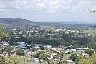
Mundubbera is a town and a locality in the North Burnett Region, Queensland, Australia. In the 2016 census, Mundubbera had a population of 1261 people.

<span class="mw-page-title-main">Burnett Highway</span> Highway in Queensland, Australia

The Burnett Highway is an inland rural highway located in Queensland, Australia. The highway runs from its junction with the Bruce Highway at Gracemere, just south of Rockhampton, to the D'Aguilar Highway in Nanango. Its length is approximately 542 kilometres. The highway takes its name from the Burnett River, which it crosses in Gayndah. The Burnett Highway provides the most direct link between the northern end of the New England Highway and Rockhampton. It is designated as a State Strategic Road by the Queensland Government.

<span class="mw-page-title-main">Gayndah</span> Town in Queensland, Australia

Gayndah is a town and locality in the North Burnett Region, Queensland, Australia. In the 2016 census, Gayndah had a population of 1,981 people. It is the administrative centre for the North Burnett Region.

<span class="mw-page-title-main">Shire of Mundubbera</span> Local government area in Queensland, Australia

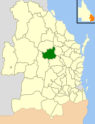
The Shire of Mundubbera was a local government area in the northern catchment of the Burnett River, Queensland, Australia. The shire covered an area of 4,192.8 square kilometres (1,618.8 sq mi), and existed as a local government area from 1915 until 2008, when it amalgamated with several other shires to form the North Burnett Region.

<span class="mw-page-title-main">Shire of Gayndah</span> Local government area in Queensland, Australia

The Shire of Gayndah was a local government area located in the northern catchment of the Burnett River, Queensland, Australia. The shire covered an area of 2,709.3 square kilometres (1,046.1 sq mi), and existed as a local government area from 1866 until 2008, when it amalgamated with several other shires to form the North Burnett Region.

<span class="mw-page-title-main">Mungar Junction to Monto railway line</span> Former railway line in Queensland, Australia

The Mungar Junction to Monto railway line is a 267-kilometre (166 mi) railway in Queensland, Australia. Progressively opened in eleven stages between 1889 and 1928 the line branched from the North Coast line at Mungar Junction a short distance west of Maryborough and followed a westerly route towards Biggenden and Gayndah before turning north via Mundubbera and Eidsvold to Monto. It is also known as the Gayndah Monto Branch Railway. In 2012, the line was officially closed.

<span class="mw-page-title-main">John Murray (pastoralist)</span> Australian politician

John Murray was a pastoralist and politician in Australia. He was a Member of the Queensland Legislative Assembly and the Queensland Legislative Council.

<span class="mw-page-title-main">Degilbo</span> Town in Queensland, Australia

Degilbo is a rural town and locality in the North Burnett Region, Queensland, Australia. In the 2016 census, the locality of Degilbo had a population of 174 people.

<span class="mw-page-title-main">Ideraway</span> Town in Queensland, Australia

Ideraway is a rural town and locality in the North Burnett Region, Queensland, Australia. In the 2016 census, the locality of Ideraway had a population of 38 people.

<span class="mw-page-title-main">Didcot, Queensland</span> Suburb of North Burnett Region, Queensland, Australia

Didcot is a rural locality in the North Burnett Region, Queensland, Australia. In the 2016 census Didcot had a population of 60 people.

Wetheron is a rural town and locality in the North Burnett Region, Queensland, Australia. In the 2016 census, Wetheron had a population of 46 people.

<span class="mw-page-title-main">Steep Rocky Creek Railway Bridge</span> Railway bridge in Queensland, Australia.

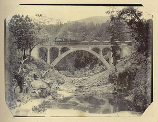
Steep Rocky Creek Railway Bridge is a heritage-listed railway bridge on the Mungar - Monto railway line at Ideraway in the North Burnett Region of Queensland, Australia. It was designed by William Pagan and built from 1906 to 1907. It was added to the Queensland Heritage Register on 21 October 1992.

<span class="mw-page-title-main">Ideraway Creek Railway Bridge</span> Historic site in Queensland, Australia

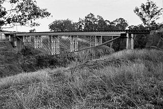
Ideraway Creek Railway Bridge is a heritage-listed railway bridge at Mungar - Monto Line, Ideraway, North Burnett Region, Queensland, Australia. It was designed by William Pagan and built from 1906 to 1907 using day labour. It was added to the Queensland Heritage Register on 21 October 1992.

<span class="mw-page-title-main">Binjour</span> Suburb of North Burnett Region, Queensland, Australia

Binjour is a rural locality in the North Burnett Region, Queensland, Australia. In the 2016 census, Binjour had a population of 98 people.

Reids Creek is a rural locality in the North Burnett Region, Queensland, Australia. In the 2016 census, Reids Creek had a population of 54 people.

<span class="mw-page-title-main">Mount Debateable, Queensland</span> Suburb of North Burnett Region, Queensland, Australia

Mount Debateable is a rural locality in the North Burnett Region, Queensland, Australia. In the 2021 census, Mount Debateable had a population of 40 people.

Dirnbir is a rural locality in the North Burnett Region, Queensland, Australia. In the 2021 census, Dirnbir had a population of 59 people.

Branch Creek is a locality in the North Burnett Region, Queensland, Australia. In the 2021 census, Branch Creek had a population of 33 people.

Mount Lawless is a rural locality in the North Burnett Region, Queensland, Australia. In the 2021 census, Mount Lawless had a population of 9 people.

The Boyne Burnett Inland Rail Trail is a recreational route for walkers, cyclists and horse riders from Taragoola to Gayndah. It uses the closed Gladstone to Monto and Mungar Junction to Monto railway corridors in Queensland, Australia.

References

  1. 1 2 3 Australian Bureau of Statistics (27 June 2017). "Gurgeena (SSC)". 2016 Census QuickStats. Retrieved 20 October 2018. OOjs UI icon edit-ltr-progressive.svg
  2. "Gurgeena – locality in North Burnett Region (entry 48110)". Queensland Place Names. Queensland Government . Retrieved 28 December 2020.
  3. "Binjour Plateau – plateau in North Burnett Region (entry 2699)". Queensland Place Names. Queensland Government . Retrieved 20 October 2022.
  4. "Gurgeena · Queensland 4626, Australia". Gurgeena · Queensland 4626, Australia. Retrieved 20 October 2022.
  5. "Binjour Range Rest Area · Swains Rd, Reids Creek QLD 4625, Australia". Binjour Range Rest Area · Swains Rd, Reids Creek QLD 4625, Australia. Retrieved 21 October 2022.
  6. admin (16 September 2012). "Binjour Range Rest Area | FREE CAMPING AUSTRALIA". www.freecampingaustralia.com.au. Retrieved 21 October 2022.
  7. 1 2 3 "Queensland Globe". State of Queensland . Retrieved 22 October 2022.
  8. 1 2 "THE GAYNDAH RAILWAY". Maryborough Chronicle, Wide Bay and Burnett Advertiser . No. 8, 260. Queensland, Australia. 2 May 1899. p. 2. Retrieved 19 October 2022 via National Library of Australia.
  9. "LEGISLATIVE COUNCIL". The Brisbane Courier . Vol. LIV, no. 12, 433. Queensland, Australia. 17 November 1897. p. 4. Retrieved 19 October 2022 via National Library of Australia.
  10. "REPORT BY R. W. WINKS". Maryborough Chronicle, Wide Bay and Burnett Advertiser . No. 7, 824. Queensland, Australia. 2 December 1897. p. 3. Retrieved 11 October 2022 via National Library of Australia.
  11. Queensland State Archives (26 September 1878). "Tracing shewing proposed resumptions from the Ideraway, Yenda, Penang, Nour Nour, Land of Promise, Branch Ck. No. 1, Prazier, Upper Chin Chin, Lower Chin Chin". Queensland Government . Retrieved 22 October 2022.
  12. "Outline Map of the Wide Bay & Burnett Districts Illustrating the Pastoral Holdings 1894". Queensland Government. 1894. Retrieved 19 October 2022.
  13. "Parish of Binjour To be open for Selection as Agricultural Farms, at the Agent for the Agent General for Queensland in London, on and after Thursday, 9th August, 1906". Queensland Government. 1906. Retrieved 19 October 2022.
  14. "QUEENSLAND". The Brisbane Courier . Vol. LV, no. 12, 806. Queensland, Australia. 27 January 1899. p. 6. Retrieved 19 October 2022 via National Library of Australia.
  15. "THE GAYNDAH DISTRICT. Ideal Areas for Settlement". The Brisbane Courier . Vol. LXII, no. 14, 995. Queensland, Australia. 2 February 1906. p. 14 (Supplement To The Brisbane Courier). Retrieved 19 October 2022 via National Library of Australia.
  16. "Parish of Binjour To be open for Selection as Agricultural Farms, at the Agent for the Agent General for Queensland in London, on and after Thursday, 9th August, 1906". Queensland Government. 1906. Retrieved 19 October 2022.
  17. Queensland Family History Society (2010), Queensland schools past and present (Version 1.01 ed.), Queensland Family History Society, ISBN   978-1-921171-26-0
  18. "Queensland Two Mile series sheet 2m116" (Map). Queensland Government. 1955. Retrieved 22 October 2022.

Further reading