Ban Ban, Queensland

Last updated

Ban Ban
Queensland
Australia Queensland location map.svg
Red pog.svg
Ban Ban
Coordinates 25°42′19″S151°49′44″E / 25.7052°S 151.8288°E / -25.7052; 151.8288 (Ban Ban (centre of locality))
Population34 (2016 census) [1]
 • Density0.1742/km2 (0.451/sq mi)
Postcode(s) 4625
Elevation150 m (492 ft) [2]
Area195.2 km2 (75.4 sq mi)
Time zone AEST (UTC+10:00)
Location
LGA(s) North Burnett Region
State electorate(s) Callide
Federal division(s) Flynn
Suburbs around Ban Ban:
Ginoondan Ginoondan Coalstoun Lakes
Campbell Creek Ban Ban Dundarrah
Stockhaven
Penwhaupell Booubyjan Blairmore

Ban Ban is a rural locality in the North Burnett Region, Queensland, Australia. [3] In the 2016 census, Ban Ban had a population of 34 people. [1]

Contents

Geography

The locality of Ban Ban completely surrounds the locality of Ban Ban Springs which is situated at the intersection of the Burnett Highway and Isis Highway. [4] [5] As such, both highways also cross Ban Ban as it surrounds the intersection.

Mount Walla (also known as Seven Hills) is in the north-east of the locality ( 25°38′43″S151°51′28″E / 25.6454°S 151.8578°E / -25.6454; 151.8578 (Mount Walla (Seven Hills)) ) and rises to 569 metres (1,867 ft) above sea level. [6] [7] It is part of the Walla Range, which extends north into Ginoondan and Coalstoun Lakes.. [8]

History

In the 2016 census, Ban Ban had a population of 34 people. [1]

Economy

There are a number of homesteads in the locality: [9]

Education

There are no schools in Ban Ban. The nearest government primary schools are Coalstoun Lakes State School in neighbouring Coalstoun Lakes to the north-east and Gayndah State School in Gayndah to the north-west. The nearest government secondary schools are Biggenden State School (to Year 10) in Biggenden to the north-east and Burnett State College (to Year 12) in Gayndah. [10]

Related Research Articles

<span class="mw-page-title-main">Gayndah</span> Town in Queensland, Australia

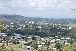
Gayndah is a town and locality in the North Burnett Region, Queensland, Australia. In the 2016 census, Gayndah had a population of 1,981 people. It is the administrative centre for the North Burnett Region.

<span class="mw-page-title-main">Biggenden</span> Town in Queensland, Australia

Biggenden is a rural town and locality in the North Burnett Region, Queensland, Australia. In the 2021 census, the locality of Biggenden had a population of 788 people.

<span class="mw-page-title-main">Shire of Perry</span> Local government area in Queensland, Australia

The Shire of Perry was a local government area in the northern catchment of the Burnett River, Queensland, Australia. The Shire covered an area of 2,357.7 square kilometres (910.3 sq mi), and existed as a local government area from 1880 until 2008, when it amalgamated with several other shires to form the North Burnett Region.

<span class="mw-page-title-main">Shire of Gayndah</span> Local government area in Queensland, Australia

The Shire of Gayndah was a local government area located in the northern catchment of the Burnett River, Queensland, Australia. The shire covered an area of 2,709.3 square kilometres (1,046.1 sq mi), and existed as a local government area from 1866 until 2008, when it amalgamated with several other shires to form the North Burnett Region.

<span class="mw-page-title-main">North Burnett Region</span> Local government area in Queensland, Australia

The North Burnett Region is a local government area in Queensland, Australia in the northern catchment of the Burnett River. Established in 2008, it was preceded by several previous local government areas with histories extending back to the early 1900s.

<span class="mw-page-title-main">Degilbo</span> Town in Queensland, Australia

Degilbo is a rural town and locality in the North Burnett Region, Queensland, Australia. In the 2016 census, the locality of Degilbo had a population of 174 people.

<span class="mw-page-title-main">Ideraway</span> Town in Queensland, Australia

Ideraway is a rural town and locality in the North Burnett Region, Queensland, Australia. In the 2016 census, the locality of Ideraway had a population of 38 people.

<span class="mw-page-title-main">Coalstoun Lakes, Queensland</span> Town in Queensland, Australia

Coalstoun Lakes is a rural town and locality in the North Burnett Region, Queensland, Australia. In the 2016 census, the locality of Coalstoun Lakes had a population of 114 people.

<span class="mw-page-title-main">Abercorn, Queensland</span> Suburb of North Burnett Region, Queensland, Australia

Abercorn is a rural town and locality in the North Burnett Region, Queensland, Australia. In the 2016 census, the locality of Abercorn had a population of 46 people.

<span class="mw-page-title-main">Didcot, Queensland</span> Suburb of North Burnett Region, Queensland, Australia

Didcot is a rural locality in the North Burnett Region, Queensland, Australia. In the 2016 census Didcot had a population of 60 people.

Wetheron is a rural town and locality in the North Burnett Region, Queensland, Australia. In the 2016 census, Wetheron had a population of 46 people.

Coringa is a rural locality in the North Burnett Region, Queensland, Australia. In the 2016 census, Coringa had a population of 77 people.

Lakeside is a rural locality in the North Burnett Region, Queensland, Australia. In the 2016 census Lakeside had a population of 55 people.

Mount Steadman is a rural locality in the North Burnett Region, Queensland, Australia. In the 2016 census Mount Steadman had a population of 8 people.

Reids Creek is a rural locality in the North Burnett Region, Queensland, Australia. In the 2016 census, Reids Creek had a population of 54 people.

<span class="mw-page-title-main">Stonelands</span> Suburb of South Burnett Region, Queensland, Australia

Stonelands is a rural locality in the South Burnett Region, Queensland, Australia. In the 2016 census, Stonelands had a population of 51 people.

<span class="mw-page-title-main">Mount Debateable, Queensland</span> Suburb of North Burnett Region, Queensland, Australia

Mount Debateable is a rural locality in the North Burnett Region, Queensland, Australia. In the 2021 census, Mount Debateable had a population of 40 people.

Bon Accord is a rural locality in the North Burnett Region, Queensland, Australia.

Barlyne is a locality in the North Burnett Region, Queensland, Australia. In the 2021 census, Barlyne had no people or a very low population.

Mount Lawless is a rural locality in the North Burnett Region, Queensland, Australia. In the 2021 census, Mount Lawless had a population of 9 people.

References

  1. 1 2 3 Australian Bureau of Statistics (27 June 2017). "Ban Ban (SSC)". 2016 Census QuickStats. Retrieved 20 October 2018. OOjs UI icon edit-ltr-progressive.svg
  2. "Ban Ban Springs Rest Area 20 Hour Limit". Caravan on Tour. Archived from the original on 29 March 2019. Retrieved 29 March 2019.
  3. "Ban Ban – locality in North Burnett Region (entry 45312)". Queensland Place Names. Queensland Government . Retrieved 7 March 2022.
  4. "Queensland Land Parcel and Property Framework" (Web Map Service). Government of Queensland. Archived from the original on 21 March 2020. Retrieved 29 March 2019.
  5. Google (29 March 2019). "Ban Ban" (Map). Google Maps . Google. Retrieved 29 March 2019.
  6. "Mountain peaks and capes - Queensland". Queensland Open Data. Queensland Government. 12 November 2020. Archived from the original on 25 November 2020. Retrieved 25 November 2020.
  7. "Mount Walla – mountain in North Burnett Region (entry 36268)". Queensland Place Names. Queensland Government . Retrieved 25 November 2020.
  8. "Mountain ranges beaches and sea passages - Queensland". Queensland Open Data. Queensland Government. 12 November 2020. Archived from the original on 25 November 2020. Retrieved 25 November 2020.
  9. "Homesteads - Queensland". Queensland Open Data. Queensland Government. 18 November 2020. Archived from the original on 24 November 2020. Retrieved 24 November 2020.
  10. "Queensland Globe". State of Queensland . Retrieved 22 July 2022.