Coringa, Queensland

Last updated

Map all coordinates using: OpenStreetMap  
Download coordinates as: KML
Coringa
Queensland
Australia Queensland location map.svg
Red pog.svg
Coringa
Coordinates 25°22′39″S151°57′54″E / 25.3775°S 151.9649°E / -25.3775; 151.9649 (Coringa (centre of locality)) Coordinates: 25°22′39″S151°57′54″E / 25.3775°S 151.9649°E / -25.3775; 151.9649 (Coringa (centre of locality))
Population77 (2016 census) [1]
 • Density0.588/km2 (1.524/sq mi)
Postcode(s) 4621
Area130.9 km2 (50.5 sq mi)
Time zone AEST (UTC+10:00)
Location
LGA(s) North Burnett Region
State electorate(s) Callide
Federal division(s) Flynn
Suburbs around Coringa:
Good Night Good Night Dallarnil
Wateranga Coringa Dallarnil
Didcot Degilbo Dallarnil

Coringa is a rural locality in the North Burnett Region, Queensland, Australia. [2] In the 2016 census, Coringa had a population of 77 people. [1]

Contents

Geography

The Burnett River forms the northern boundary of the locality. At the west of the locality is the Paradise Dam ( 25°21′01″S151°55′08″E / 25.3503°S 151.9189°E / -25.3503; 151.9189 (Paradise Dam) ) which creates Lake Paradise. The filling of the dam flooded most of the former town of Paradise ( 25°21′12″S151°55′15″E / 25.3533°S 151.9208°E / -25.3533; 151.9208 (Paradise (former town)) ). [3] [4]

History

The town of Paradise was established in 1889 as a gold mining township. It was on the Burnett River. The town reserve was established on 20 July 1891. In 1898, the town was abandoned when the gold rush was over. [4] [5] At its peak, Paradise had a population of over 2,000 people. [6]

Paradise Provisional School opened about 1892 and closed in 1904. [7] In December 1905, tenders were called to relocate the school building to Mount Shamrock. [8]

Coringa Provisional School opened on 3 November 1930. In 1936, it become Coringa State School. It closed on 21 June 1996. [9] [10] It is on Coringa Road ( 25°23′03″S151°58′39″E / 25.3843°S 151.9775°E / -25.3843; 151.9775 (Coringa State School (former)) ). [11] [12] [3]

Paradise Dam was completed in 2005, inundating the town of Paradise. [5]

In the 2016 census, Coringa had a population of 77 people. [1]

Heritage listings

Coringa has a number of heritage-listed sites, including:

Education

There are no schools in Coringa. The nearest government primary schools are Dallarnil State School in neighbouring Dallarnil to the east and Biggenden State School in Biggenden to the south-east. Biggenden State School also offers secondary schooling to Year 10. The nearest government secondary schools offering secondary schooling to Year 12 are Isis District State High School in Childers to the north-east and Burnett State College in Gayndah to the south-west. [3]

Related Research Articles

Biggenden Town in Queensland, Australia

Biggenden is a rural town and locality in the North Burnett Region, Queensland, Australia. In the 2016 census, Biggenden had a population of 845 people.

Shire of Biggenden Local government area in Queensland, Australia

The Shire of Biggenden was a local government area located in the northern catchment of the Burnett River, Queensland, Australia, 100 kilometres (62 mi) south-southwest of the regional city of Bundaberg. The shire covered an area of 1,314.5 square kilometres (507.5 sq mi), and existed as a local government area from 1905 until 2008, when it amalgamated with several other shires to become the North Burnett Region.

Paradise, Queensland Town in Queensland, Australia

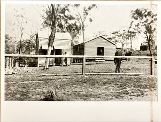
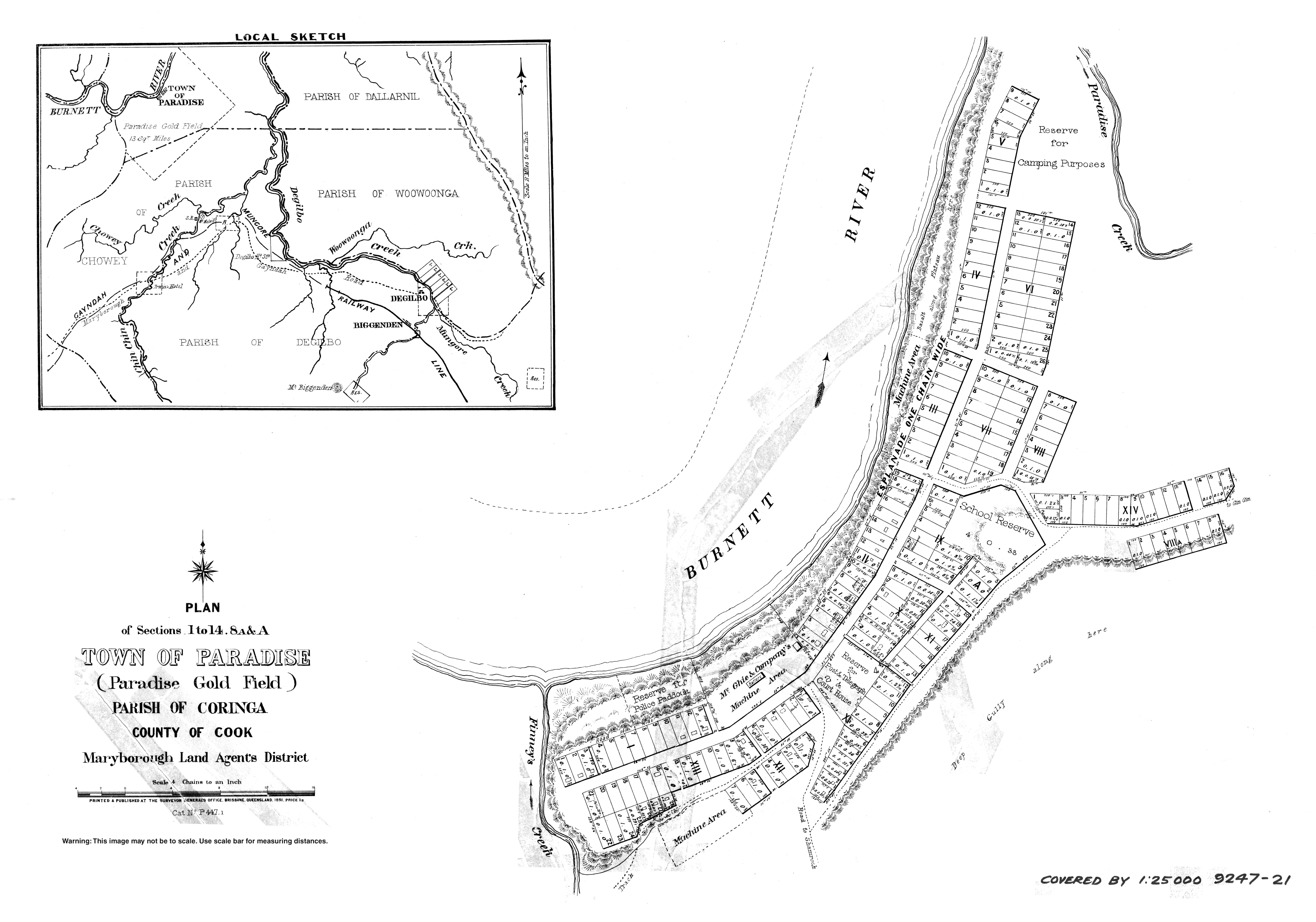
Paradise is a town on the Burnett River, in Queensland, Australia, within the present-day locality of Coringa in the North Burnett Region. It no longer exists.

Degilbo Town in Queensland, Australia

Degilbo is a rural town and locality in the North Burnett Region, Queensland, Australia. In the 2016 census, the locality of Degilbo had a population of 174 people.

Ideraway Town in Queensland, Australia

Ideraway is a rural town and locality in the North Burnett Region, Queensland, Australia. In the 2016 census, the locality of Ideraway had a population of 38 people.

Coalstoun Lakes, Queensland Town in Queensland, Australia

Coalstoun Lakes is a rural town and locality in the North Burnett Region, Queensland, Australia. In the 2016 census, the locality of Coalstoun Lakes had a population of 114 people.

Abercorn, Queensland Suburb of North Burnett Region, Queensland, Australia

Abercorn is a rural town and locality in the North Burnett Region, Queensland, Australia. In the 2016 census, the locality of Abercorn had a population of 46 people.

Didcot, Queensland Suburb of North Burnett Region, Queensland, Australia

Didcot is a rural locality in the North Burnett Region, Queensland, Australia. In the 2016 census Didcot had a population of 60 people.

Gordonbrook is a rural locality in the South Burnett Region, Queensland, Australia. In the 2016 census Gordonbrook had a population of 175 people.

Boondooma is a rural locality in the South Burnett Region, Queensland, Australia. In the 2016 census, Boondooma had a population of 76 people.

Cynthia is a rural town and locality in the North Burnett Region, Queensland, Australia. In the 2016 census, Cynthia had a population of 31 people.

Dallarnil is a rural town and locality in the North Burnett Region, Queensland, Australia. In the 2016 census, Dallarnil had a population of 230 people. The neighbourhood of Stanton is within the locality.

Kalpowar Town in Queensland, Australia

Kalpowar is a town in the North Burnett Region and a locality split between the North Burnett Region and the Bundaberg Region, in Queensland, Australia. In the 2016 census, the locality of Kalpowar had a population of 67 people.

Bancroft, Queensland Suburb of North Burnett Region, Queensland, Australia

Bancroft is a rural locality in the North Burnett Region, Queensland, Australia. In the 2016 census, Bancroft had a population of 96 people.

Kapaldo is a rural town and locality in the North Burnett Region, Queensland, Australia. In the 2016 census, the locality of Kapaldo had a population of 43 people.

Moonford is a rural town and locality in the North Burnett Region, Queensland, Australia. In the 2016 census, the locality of Moonford had a population of 160 people.

Mount Steadman is a rural locality in the North Burnett Region, Queensland, Australia. In the 2016 census Mount Steadman had a population of 8 people.

Ban Ban is a rural locality in the North Burnett Region, Queensland, Australia. In the 2016 census, Ban Ban had a population of 34 people.

Golden Fleece is a locality in the North Burnett Region, Queensland, Australia. In the 2016 census, Golden Fleece had a population of 49 people.

Woowoonga is a locality in the North Burnett Region, Queensland, Australia. In the 2016 census, Woowoonga had a population of 92 people.

References

  1. 1 2 3 Australian Bureau of Statistics (27 June 2017). "Coringa (SSC)". 2016 Census QuickStats. Retrieved 20 October 2018. OOjs UI icon edit-ltr-progressive.svg
  2. "Coringa – locality in North Burnett Region (entry 45336)". Queensland Place Names. Queensland Government . Retrieved 7 March 2022.
  3. 1 2 3 "Queensland Globe". State of Queensland . Retrieved 4 May 2022.
  4. 1 2 "Paradise – unbounded locality in the North Burnett Region (entry 26024)". Queensland Place Names. Queensland Government . Retrieved 16 August 2019.
  5. 1 2 "Paradise Dam". Sunwater. Archived from the original on 20 January 2022. Retrieved 4 May 2022.
  6. 1 2 "Paradise Cemetery" (PDF). North Burnett Local Heritage Register. North Burnett Regional Council. p. 64. Archived (PDF) from the original on 16 August 2019. Retrieved 16 August 2019.
  7. Queensland Family History Society (2010), Queensland schools past and present (Version 1.01 ed.), Queensland Family History Society, ISBN   978-1-921171-26-0
  8. "Official Notifications". The Telegraph . No. 10316. Queensland, Australia. 9 December 1905. p. 2 (SECOND EDITION). Archived from the original on 25 July 2022. Retrieved 25 July 2022 via National Library of Australia.
  9. Queensland Family History Society (2010), Queensland schools past and present (Version 1.01 ed.), Queensland Family History Society, ISBN   978-1-921171-26-0
  10. "Queensland state school - centre closures" (PDF). Queensland Government . 20 August 2013. Archived (PDF) from the original on 20 March 2022. Retrieved 7 April 2022.
  11. "Parish of Coringa" (Map). Queensland Government. 1968. Archived from the original on 4 May 2022. Retrieved 4 May 2022.
  12. "9247 Mount Perry" (Map). Queensland Government. 1971. Archived from the original on 4 May 2022. Retrieved 4 May 2022.