Derri Derra

Last updated

Derri Derra
Queensland
Australia Queensland location map.svg
Red pog.svg
Derri Derra
Coordinates 25°42′19″S151°14′59″E / 25.7052°S 151.2497°E / -25.7052; 151.2497 (Derri Derra (centre of locality))
Population115 (2021 census) [1]
 • Density0.6277/km2 (1.626/sq mi)
Postcode(s) 4626
Area183.2 km2 (70.7 sq mi)
Time zone AEST (UTC+10:00)
Location
LGA(s) North Burnett Region
State electorate(s) Callide
Federal division(s) Flynn
Suburbs around Derri Derra:
Riverleigh Boynewood Glenrae
Dykehead Derri Derra Old Cooranga
Brovinia Beeron Old Cooranga

Derri Derra is a rural locality in the North Burnett Region, Queensland, Australia. [2] In the 2021 census, Derri Derra had a population of 115 people. [1]

Contents

Geography

The Burnett River forms part of the northern boundary. The Auburn River forms most of the western boundary before joining the Burnett in the north-west. The Boyne River forms the eastern boundary and most of the northern before also joining the Burnett. [3]

The Mundubbera-Durong Road (State Route 75) runs through from north to south.

History

Derri Derra Provisional School opened on 7 March 1927. In 1951 it became Derri Derra State School. It closed on 6 August 1971. [4] It was on the north-west corner of the junction of Mundubbera Durong Road and Back Derra Road ( 25°43′23″S151°13′00″E / 25.72314°S 151.21660°E / -25.72314; 151.21660 (Derri Derra State School (former)) ). [5] [6]

Beeron Road Provisional School opened on 5 September 1927. In 1952, it became Beeron Road State School. It closed on 11 December 1987. [4] It was at 1070 Beeron Road ( 25°43′49″S151°18′01″E / 25.7303°S 151.30033°E / -25.7303; 151.30033 (Beeron Road State School (former)) ). [7] [8] The school building is still extant and is used by the Beeron Road Country Club. [9]

Demographics

In the 2016 census, Derri Derra had a population of 146 people. [10]

In the 2021 census, Derri Derra had a population of 115 people. [1]

Education

There are no schools in Derri Derra. The nearest government primary school is Boynewood State School in neighbouring Boynewood to the north. The nearest government secondary schools are Mundubbera State College (to Year 10) in Mundubbera to the north-east, Burnett State College (to Year 12) in Gayndah to the north-east, and Eidsvold State School (to Year 12) in Eidsvold to the north. [11]

Related Research Articles

<span class="mw-page-title-main">Mundubbera</span> Town in Queensland, Australia

Mundubbera is a rural town and a locality in the North Burnett Region, Queensland, Australia. In the 2021 census, the locality of Mundubbera had a population of 1,120 people.

<span class="mw-page-title-main">Eidsvold, Queensland</span> Town in Queensland, Australia

Eidsvold is a rural town and locality in the North Burnett Region, Queensland, Australia. The town is the self-proclaimed Beef Capital of the Burnett and is a hub for the regional cattle industry. In the 2021 census, the locality of Eidsvold had a population of 538 people.

<span class="mw-page-title-main">Ceratodus, Queensland</span> Town in Queensland, Australia

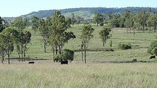
Ceratodus is a rural town and locality in the North Burnett Region, Queensland, Australia. In the 2021 census, the locality of Ceratodus had a population of 34 people.

<span class="mw-page-title-main">Degilbo</span> Town in Queensland, Australia

Degilbo is a rural town and locality in the North Burnett Region, Queensland, Australia. In the 2021 census, the locality of Degilbo had a population of 182 people.

<span class="mw-page-title-main">Durong, Queensland</span> Suburb of South Burnett Region, Queensland, Australia

Durong is a rural locality in the South Burnett Region, Queensland, Australia. In the 2021 census, Durong had a population of 219 people.

Boondooma is a rural locality in the South Burnett Region, Queensland, Australia. In the 2021 census, Boondooma had a population of 70 people.

Langley is a rural locality in the North Burnett Region, Queensland, Australia.

Beeron is a rural locality in the North Burnett Region, Queensland, Australia. In the 2021 census, Beeron had a population of 34 people.

Brovinia is a rural locality in the North Burnett Region, Queensland, Australia. In the 2021 census, Brovinia had "no people or a very low population".

Glenrae is a rural locality in the North Burnett Region, Queensland, Australia. In the 2021 census, Glenrae had a population of 63 people.

Gurgeena is a rural locality in the North Burnett Region, Queensland, Australia. In the 2021 census, Gurgeena had a population of 36 people.

<span class="mw-page-title-main">Mundowran</span> Suburb of North Burnett Region, Queensland, Australia

Mundowran is a rural locality in the North Burnett Region, Queensland, Australia. In the 2021 census, Mundowran had a population of 119 people.

Riverleigh is a rural locality in the North Burnett Region, Queensland, Australia. In the 2021 census, Riverleigh had a population of 95 people.

Boynewood is a rural locality in the North Burnett Region, Queensland, Australia. In the 2021 census, Boynewood had a population of 138 people.

Coonambula is a locality in the North Burnett Region, Queensland, Australia. In the 2021 census, Coonambula had a population of 80 people.

Old Cooranga is a rural locality in the North Burnett Region, Queensland, Australia. In the 2021 census, Old Cooranga had a population of 29 people.

Branch Creek is a locality in the North Burnett Region, Queensland, Australia. In the 2021 census, Branch Creek had a population of 33 people.

Grosvenor is a locality in the North Burnett Region, Queensland, Australia. In the 2021 census, Grosvenor had a population of 29 people.

Eidsvold East is a rural locality in the North Burnett Region, Queensland, Australia. In the 2021 census, Eidsvold East had a population of 27 people.

Mundubbera–Durong Road is a continuous 105-kilometre (65 mi) road route in the North Burnett and South Burnett local government areas of Queensland, Australia. It is signed as State Route 75. It is a state-controlled regional road. It has been designated as a road of strategic importance by the Federal Government.

References

  1. 1 2 3 Australian Bureau of Statistics (28 June 2022). "Derri Derra (SAL)". 2021 Census QuickStats. Retrieved 28 February 2023. OOjs UI icon edit-ltr-progressive.svg
  2. "Derri Derra – locality in North Burnett Region (entry 45341)". Queensland Place Names. Queensland Government . Retrieved 28 December 2020.
  3. Google (20 August 2021). "Derri Derra, Queensland" (Map). Google Maps . Google. Retrieved 20 August 2021.
  4. 1 2 Queensland Family History Society (2010), Queensland schools past and present (Version 1.01 ed.), Queensland Family History Society, ISBN   978-1-921171-26-0
  5. "Parish of Derra" (Map). Queensland Government. 1971. Archived from the original on 10 January 2021. Retrieved 30 December 2020.
  6. "Queensland Globe". State of Queensland . Retrieved 28 December 2020.
  7. "Queensland Two Mile series sheet 2m116" (Map). Queensland Government. 1938. Archived from the original on 31 October 2023. Retrieved 31 October 2023.
  8. "Mundubbera" (Map). Queensland Government. 1971. Archived from the original on 28 December 2020. Retrieved 28 December 2020.
  9. "Beeron Road Country Club". Facebook . Archived from the original on 31 October 2023. Retrieved 31 October 2023.
  10. Australian Bureau of Statistics (27 June 2017). "Derri Derra (SSC)". 2016 Census QuickStats. Retrieved 20 October 2018. OOjs UI icon edit-ltr-progressive.svg
  11. "Layers: Locality; Schools and school catchments". Queensland Globe. Queensland Government. Archived from the original on 19 December 2017. Retrieved 14 July 2024.

Further reading