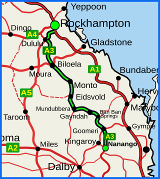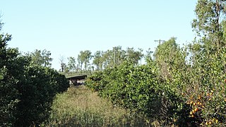
The Burnett Highway is an inland rural highway located in Queensland, Australia. The highway runs from its junction with the Bruce Highway at Gracemere, just south of Rockhampton, to the D'Aguilar Highway in Nanango. Its length is approximately 542 kilometres. The highway takes its name from the Burnett River, which it crosses in Gayndah. The Burnett Highway provides the most direct link between the northern end of the New England Highway and Rockhampton. It is designated as a State Strategic Road by the Queensland Government.

Eidsvold is a rural town and locality in the North Burnett Region, Queensland, Australia. The town is the self-proclaimed Beef Capital of the Burnett and is a hub for the regional cattle industry. In the 2021 census, the locality of Eidsvold had a population of 538 people.

Mount Perry is a rural town and locality in the North Burnett Region, Queensland, Australia. In the 2021 census, the locality of Mount Perry had a population of 487 people.

Monto is a rural town and locality in the North Burnett Region, Queensland, Australia. In the 2021 census, the locality of Monto had a population of 1,156 people.

Mulgildie is a rural town and locality in the North Burnett Region, Queensland, Australia. In the 2021 census, the locality of Mulgildie had a population of 147 people.

Kumbia is a rural town and locality in the South Burnett Region, Queensland, Australia. In the 2021 census, the locality of Kumbia had a population of 301 people.

Tinana is a rural town and locality in the Fraser Coast Region, Queensland, Australia. In the 2021 census, the locality of Tinana had a population of 5,872 people.

Ideraway is a rural town and locality in the North Burnett Region, Queensland, Australia. In the 2021 census, the locality of Ideraway had a population of 31 people.

Coalstoun Lakes is a rural town and locality in the North Burnett Region, Queensland, Australia. In the 2021 census, the locality of Coalstoun Lakes had a population of 99 people.

Durong is a rural locality in the South Burnett Region, Queensland, Australia. In the 2021 census, Durong had a population of 219 people.
Wetheron is a rural town and locality in the North Burnett Region, Queensland, Australia. In the 2021 census, the locality of Wetheron had a population of 40 people.

Bancroft is a rural locality in the North Burnett Region, Queensland, Australia. In the 2021 census, Bancroft had a population of 98 people.
Harrami is a rural locality in the North Burnett Region, Queensland, Australia. In the 2021 census, Harrami had a population of 22 people.
Riverleigh is a rural locality in the North Burnett Region, Queensland, Australia. In the 2021 census, Riverleigh had a population of 95 people.
Three Moon is a rural locality in the North Burnett Region, Queensland, Australia. In the 2021 census, Three Moon had a population of 178 people.

Mungungo is a rural town and locality in the North Burnett Region, Queensland, Australia. In the 2021 census, the locality of Mungungo had a population of 84 people.

Cania is a locality in the North Burnett Region, Queensland, Australia. In the 2021 census, Cania had a population of 27 people.
Monal is a locality in the North Burnett Region, Queensland, Australia. In the 2021 census, Monal had a population of 34 people.
Selene is a rural locality in the North Burnett Region, Queensland, Australia. In the 2021 census, Selene had a population of 27 people.
Mount Lawless is a rural locality in the North Burnett Region, Queensland, Australia. In the 2021 census, Mount Lawless had a population of 9 people.


