Mount Debateable, Queensland

Last updated

Mount Debateable
Queensland
StateLibQld 1 154275 Pupils and families from the Mt Debateable State School, 1914.jpg
Pupils and families from the Mt Debateable State School, 1914
Australia Queensland location map.svg
Red pog.svg
Mount Debateable
Coordinates 25°37′54″S151°33′24″E / 25.6316°S 151.5566°E / -25.6316; 151.5566 Coordinates: 25°37′54″S151°33′24″E / 25.6316°S 151.5566°E / -25.6316; 151.5566
Population54 (2016 census) [1]
 • Density2.523/km2 (6.54/sq mi)
Postcode(s) 4625
Area21.4 km2 (8.3 sq mi)
Time zone AEST (UTC+10:00)
LGA(s) North Burnett Region
State electorate(s) Callide
Federal division(s) Flynn
Suburbs around Mount Debateable:
Dirnbir Dirnbir Dirnbir
Deep Creek Mount Debateable Gayndah
Woodmillar Woodmillar Woodmillar

Mount Debateable is a rural locality in the North Burnett Region, Queensland, Australia. [2] In the 2016 census, Mount Debateable had a population of 54 people. [1]

Contents

Geography

The Burnett River forms the northern boundary of the locality. There are two peaks in the locality: Mount Debateable at an elevation of 261 metres (856 ft) in the north of the locality and White Hill at 122 metres (400 ft) in the north-east. [3]

The principal land use is grazing with some irrigated cropping near the Burnett River. [3]

The Gayndah Mundubbera Road passes through the locality from east (Gayndah) to west (Deep Creek). [3]

Despite the name, the Mount Debateable railway station is not in the locality but in Dirnbir north of the river. [3] [4]

History

The locality takes its name from the mountain, which in turn takes its name from the Mount Debateable pastoral run taken up in 1851 by George Mocatta. Although it is sometimes written as Mount Debatable, in February 1987, the Queensland Place Names Board confirmed the official spelling to be Mount Debateable. [2] [5]

In January 1912, tenders were called to build a state school in Mount Debateable. [6] A new school building was built in 1926 and the school renamed Granite Hill State School. [7] [8] It closed in 1957. [9]

Education

There are no schools in Mount Debateable. The nearest primary and secondary schools are in neighbouring Gayndah. [3]

Related Research Articles

<span class="mw-page-title-main">Gayndah</span> Town in Queensland, Australia

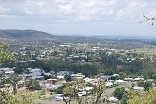
Gayndah is a town and locality in the North Burnett Region, Queensland, Australia. In the 2016 census, Gayndah had a population of 1,981 people. It is the administrative centre for the North Burnett Region.

<span class="mw-page-title-main">Ideraway</span> Town in Queensland, Australia

Ideraway is a rural town and locality in the North Burnett Region, Queensland, Australia. In the 2016 census, the locality of Ideraway had a population of 38 people.

<span class="mw-page-title-main">Didcot, Queensland</span> Suburb of North Burnett Region, Queensland, Australia

Didcot is a rural locality in the North Burnett Region, Queensland, Australia. In the 2016 census Didcot had a population of 60 people.

Wetheron is a rural town and locality in the North Burnett Region, Queensland, Australia. In the 2016 census, Wetheron had a population of 46 people.

<span class="mw-page-title-main">Mount French, Queensland</span> Suburb of Scenic Rim Region, Queensland, Australia

Mount French is a rural locality in the Scenic Rim Region, Queensland, Australia. In the 2016 census, Mount French had a population of 94 people.

<span class="mw-page-title-main">Kalpowar</span> Town in Queensland, Australia

Kalpowar is a town in the North Burnett Region and a locality split between the North Burnett Region and the Bundaberg Region, in Queensland, Australia. In the 2016 census, the locality of Kalpowar had a population of 67 people.

Coringa is a rural locality in the North Burnett Region, Queensland, Australia. In the 2016 census, Coringa had a population of 77 people.

Mount Steadman is a rural locality in the North Burnett Region, Queensland, Australia. In the 2016 census Mount Steadman had a population of 8 people.

Reids Creek is a rural locality in the North Burnett Region, Queensland, Australia. In the 2016 census Reids Creek had a population of 54 people.

<span class="mw-page-title-main">Stonelands</span> Suburb of South Burnett Region, Queensland, Australia

Stonelands is a rural locality in the South Burnett Region, Queensland, Australia. In the 2016 census, Stonelands had a population of 51 people.

Mingo is a rural locality in the North Burnett Region, Queensland, Australia. In the 2016 census, Mingo had a population of 8 people.

Ban Ban is a rural locality in the North Burnett Region, Queensland, Australia. In the 2016 census, Ban Ban had a population of 34 people.

Old Cooranga is a rural locality in the North Burnett Region, Queensland, Australia. In the 2016 census, Old Cooranga had a population of 27 people.

Pile Gully is a rural locality in the North Burnett Region, Queensland, Australia. In the 2016 census, Pile Gully had a population of 3 people.

Deep Creek is a rural locality in the North Burnett Region, Queensland, Australia. In the 2016 census, Deep Creek had a population of 16 people.

Dirnbir is a rural locality in the North Burnett Region, Queensland, Australia. In the 2016 census, Dirnbir had a population of 49 people.

Woowoonga is a locality in the North Burnett Region, Queensland, Australia. In the 2016 census, Woowoonga had a population of 92 people.

Yenda is a rural locality in the North Burnett Region, Queensland, Australia. In the 2016 census, Yenda had a population of 23 people.

Burnett Creek is a rural locality in the Scenic Rim Region, Queensland, Australia. In the 2016 census, Burnett Creek had a population of 11 people. It borders New South Wales to the south.

Mount Lawless is a rural locality in the North Burnett Region, Queensland, Australia. In the 2016 census, Mount Lawless had a population of 12 people.

References

  1. 1 2 Australian Bureau of Statistics (27 June 2017). "Mount Debateable (SSC)". 2016 Census QuickStats. Retrieved 20 October 2018. OOjs UI icon edit-ltr-progressive.svg
  2. 1 2 "Mount Debateable – locality in North Burnett Region (entry 45393)". Queensland Place Names. Queensland Government . Retrieved 11 June 2019.
  3. 1 2 3 4 5 "Queensland Globe". State of Queensland . Retrieved 31 July 2019.
  4. "Mount Debateable – railway station in the Burnett Region (entry 23010)". Queensland Place Names. Queensland Government . Retrieved 31 July 2019.
  5. "Mount Debateable – mountain in the Burnett Region (entry 9557)". Queensland Place Names. Queensland Government . Retrieved 31 July 2019.
  6. "PUBLIC WORKS TENDERS". The Telegraph . No. 12, 212. Queensland, Australia. 8 January 1912. p. 2. Retrieved 31 July 2019 via National Library of Australia.
  7. "Item ID15511, Mount Debateable No.1365 State School". Queensland State Archives . Retrieved 31 July 2019.
  8. "NEW STATE SCHOOLS". The Brisbane Courier . No. 21, 292. Queensland, Australia. 23 April 1926. p. 10. Retrieved 31 July 2019 via National Library of Australia.
  9. "Opening and closing dates of Queensland Schools". Queensland Government . Retrieved 31 July 2019.

Further reading