Paradise, Queensland

Last updated

Map all coordinates using: OpenStreetMap  
Download coordinates as: KML
Paradise
Coringa,  Queensland
Paradise Wesleyan Methodist Church, 1892.pdf
Wesleyan Methodist parsonage (left) and church (right), 1892
Australia Queensland location map.svg
Red pog.svg
Paradise
Coordinates 25°21′12″S151°55′15″E / 25.3533°S 151.9208°E / -25.3533; 151.9208 (Paradise (town centre)) Coordinates: 25°21′12″S151°55′15″E / 25.3533°S 151.9208°E / -25.3533; 151.9208 (Paradise (town centre))
Postcode(s) 4621
Time zone AEST (UTC+10:00)
Location
LGA(s) North Burnett Region
State electorate(s) Callide
Federal division(s) Flynn

Paradise is a town on the Burnett River, in Queensland, Australia, within the present-day locality of Coringa in the North Burnett Region. Although it is still officially gazetted as a town, the town no longer has buildings or people. [1]

Contents

History

The town was established as a gold mining centre and was abandoned once the gold ran out. The main reef on the goldfield extended for two miles along Finneys Creek. [2]

A post office opened on 3 April 1890 and closed about June 1905. [2] [3]

A town reserve was proclaimed on 20 July 1891. [2]

Paradise Provisional School opened about 1892 and closed in 1904. [4] It was at 25°21′15″S151°55′14″E / 25.3542°S 151.9206°E / -25.3542; 151.9206 (Paradise Provisional School (former)) . [5] In December 1905, tenders were called to relocate the school building to Mount Shamrock. [6]

The Paradise Public Hall was relocated to Mount Shamrock where it was officially repened circa September 1905. [7]

The town site is partially inundated by Lake Paradise, formed by the construction of Paradise Dam on the Burnett River. [1] Prior to inundation, an archaeological excavation of the town site was conducted by the University of Queensland archaeological services unit, revealing much about life in Queensland gold rush towns. [8]

See also

Related Research Articles

Kingaroy Town in Queensland, Australia

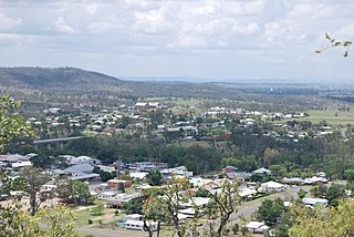
Kingaroy is a rural town and locality in the South Burnett Region, Queensland, Australia. It is approximately 210 kilometres (130 mi) or about 2½ hours drive north-west of the state capital Brisbane. The town is situated on the junction of the D'Aguilar and the Bunya Highways. In the 2016 census, the locality of Kingaroy had a population of 10,020 people. As at June 2018, Kingaroy had a population of 10,398

Gayndah Town in Queensland, Australia

Gayndah is a town and locality in the North Burnett Region, Queensland, Australia. In the 2016 census, Gayndah had a population of 1,981 people. It is the administrative centre for the North Burnett Region.

Nanango Town in Queensland, Australia

Nanango is a rural town and locality in the South Burnett Region, Queensland, Australia. In the 2016 census, the locality of Nanango had a population of 3,599 people.

Biggenden Town in Queensland, Australia

Biggenden is a rural town and locality in the North Burnett Region, Queensland, Australia. In the 2016 census, Biggenden had a population of 845 people.

Mount Perry, Queensland Town in Queensland, Australia

Mount Perry is a small town and locality in the North Burnett Region in southeastern Queensland, Australia. In the 2016 census, Mount Perry had a population of 538 people. The neighbourhood of Drummers Creek is in the locality.

Monto, Queensland Town in Queensland, Australia

Monto is a rural town and locality in the North Burnett Region, Queensland, Australia. In the 2021 census, Monto had a population of 1,156 people.

Mulgildie Town in Queensland, Australia

Mulgildie is a town and a locality in the North Burnett Region, Queensland, Australia. In the 2016 census, Mulgildie had a population of 174 people.

Cherbourg, Queensland Town in Queensland, Australia

Cherbourg, formerly known as Barambah, Barambah Aboriginal Settlement and Cherbourg Aboriginal Settlement, is a rural town and locality in the Aboriginal Shire of Cherbourg, Queensland, Australia.

Many Peaks, Queensland Town in Queensland, Australia

Many Peaks is a town in Gladstone Region in Queensland, Australia. It is one of four small townships within the locality of Boyne Valley along with Nagoorin, Builyan and Ubobo.

Hivesville, Queensland Town in Queensland, Australia

Hivesville is a rural town and locality in the South Burnett Region, Queensland, Australia. In the 2016 census, the locality of Hivesville had a population of 169 people.

Memerambi, Queensland Town in Queensland, Australia

Memerambi is a rural town and locality in the South Burnett Region, Queensland, Australia. In the 2016 census, the locality of Memerambi had a population of 272 people.

Gunalda Town in Queensland, Australia

Gunalda is a rural town in the Gympie Region and a locality split between Gympie Region and Fraser Coast Region in Queensland, Australia. In the 2016 census, the locality of Gunalda had a population of 392 people.

Degilbo Town in Queensland, Australia

Degilbo is a rural town and locality in the North Burnett Region, Queensland, Australia. In the 2016 census, the locality of Degilbo had a population of 174 people.

Ideraway Town in Queensland, Australia

Ideraway is a rural town and locality in the North Burnett Region, Queensland, Australia. In the 2016 census, the locality of Ideraway had a population of 38 people.

Maidenwell is a rural town and locality in the South Burnett Region, Queensland, Australia. In the 2016 census, the locality of Maidenwell had a population of 199 people.

Abercorn, Queensland Suburb of North Burnett Region, Queensland, Australia

Abercorn is a rural town and locality in the North Burnett Region, Queensland, Australia. In the 2016 census, the locality of Abercorn had a population of 46 people.

Didcot, Queensland Suburb of North Burnett Region, Queensland, Australia

Didcot is a rural locality in the North Burnett Region, Queensland, Australia. In the 2016 census Didcot had a population of 60 people.

Kalpowar Town in Queensland, Australia

Kalpowar is a town in the North Burnett Region and a locality split between the North Burnett Region and the Bundaberg Region, in Queensland, Australia. In the 2016 census, the locality of Kalpowar had a population of 67 people.

Bancroft, Queensland Suburb of North Burnett Region, Queensland, Australia

Bancroft is a rural locality in the North Burnett Region, Queensland, Australia. In the 2016 census, Bancroft had a population of 96 people.

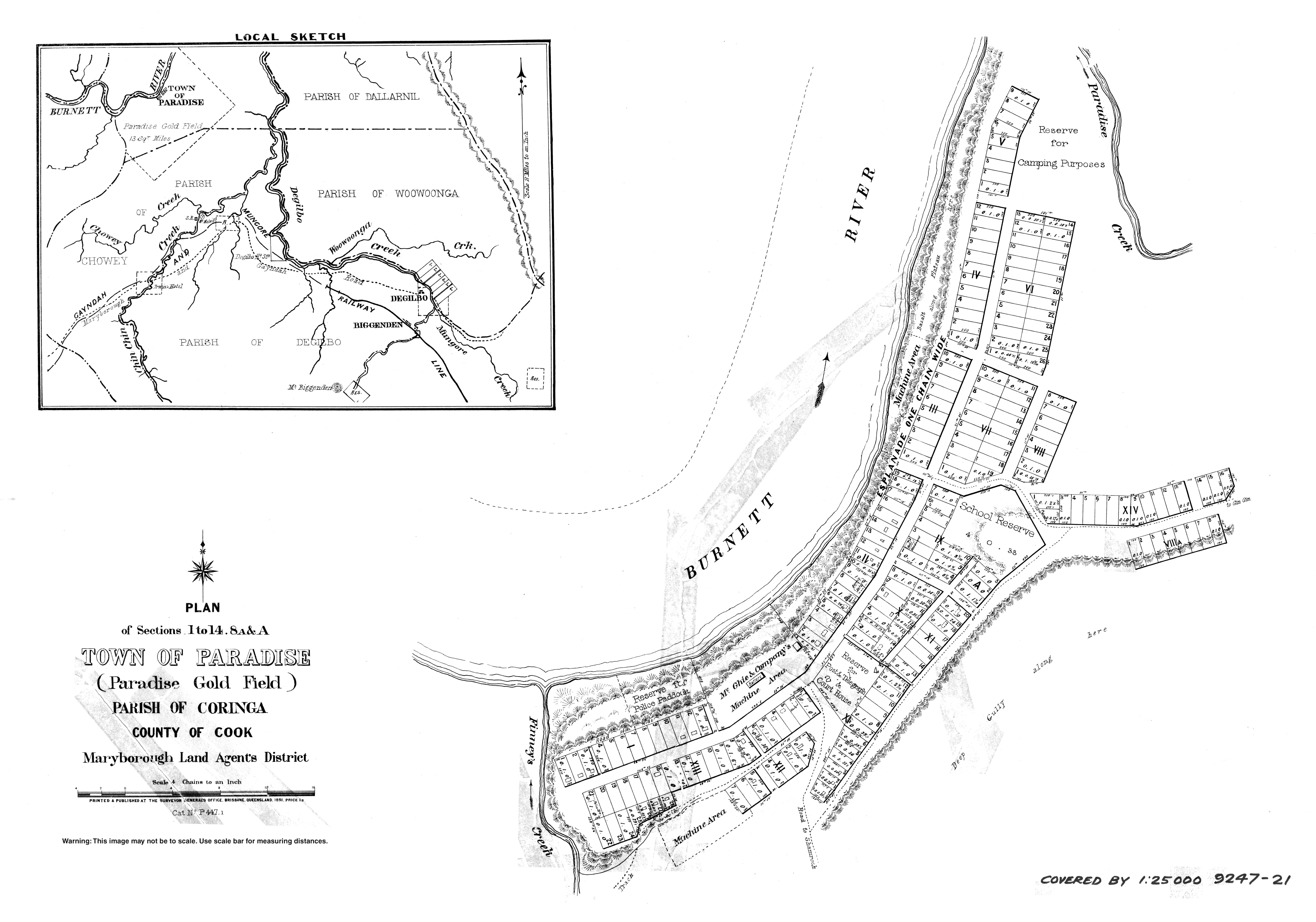
Coringa is a rural locality in the North Burnett Region, Queensland, Australia. In the 2016 census, Coringa had a population of 77 people.

References

  1. 1 2 "Paradise – population centre (absent feature) in the North Burnett Region (entry 26024)". Queensland Place Names. Queensland Government . Retrieved 26 July 2022.
  2. 1 2 3 Frew, Joan (1981) Queensland Post Offices 1842-1980 and Receiving Offices 1869-1927, p. 387. Fortitude Valley, Queensland: published by the author, ISBN   0-9593973-0-2
  3. Premier Postal History. "Post Office List". Premier Postal Auctions. Archived from the original on 15 May 2014. Retrieved 10 May 2014.
  4. Queensland Family History Society (2010), Queensland schools past and present (Version 1.01 ed.), Queensland Family History Society, ISBN   978-1-921171-26-0
  5. "Town of Paradise" (Map). Queensland Government. 1891. Archived from the original on 4 May 2022. Retrieved 3 August 2022.
  6. "Official Notifications". The Telegraph . No. 10316. Queensland, Australia. 9 December 1905. p. 2 (SECOND EDITION). Archived from the original on 25 July 2022. Retrieved 25 July 2022 via National Library of Australia.
  7. "Country news". The Brisbane Courier . Vol. LXII, no. 14, 895. Queensland, Australia. 7 October 1905. p. 14. Retrieved 25 July 2022 via National Library of Australia.
  8. van de Wetering, Jodie (9 September 2005). "The official history of Paradise". ABC Wide Bay . Retrieved 23 May 2007.[ dead link ]

Further reading