Dirnbir, Queensland

Last updated

Dirnbir
Queensland
Australia Queensland location map.svg
Red pog.svg
Dirnbir
Coordinates 25°35′54″S151°32′34″E / 25.5983°S 151.5427°E / -25.5983; 151.5427 (Dirnbir (centre of locality))
Population59 (2021 census) [1]
 • Density1.735/km2 (4.49/sq mi)
Postcode(s) 4625
Area34.0 km2 (13.1 sq mi)
Time zone AEST (UTC+10:00)
Location
LGA(s) North Burnett Region
State electorate(s) Callide
Federal division(s) Flynn
Suburbs around Dirnbir:
Humphery Reids Creek Ideraway
Humphery Dirnbir Gayndah
Deep Creek Mount Debateable Gayndah

Dirnbir is a rural locality in the North Burnett Region, Queensland, Australia. [2] In the 2021 census, Dirnbir had a population of 59 people. [1]

Contents

Geography

The Burnett River forms the southern boundary of the locality at an elevation of 100 metres (330  ft ) while Reid Creek (a tributary of the Burnett River) forms the eastern boundary. The land in the locality rises toward the north with two peaks: Mount Gayndah in the south of the locality at 364 metres (1,194 ft) and an unnamed peak in the south-west at 340 metres (1,120 ft). A number of creeks rise in the locality and flow south or east to become tributaries of the Burnett River or Reid Creek respectively. [3]

The more mountainous areas are undeveloped land. The predominant land use is grazing with some irrigated farming near the Burnett River. [3]

History

The locality takes its name from the Dirnbir railway station ( 25°36′24″S151°33′31″E / 25.60667°S 151.55861°E / -25.60667; 151.55861 (Dirnbir railway station) ) on the now closed Mungar Junction to Monto branch railway. The Queensland Railways Department named the station on 28 February 1913 using an Aboriginal word meaning grey ironbark tree. [4] [5]

The Mount Debateable railway station was also located in the locality at 25°37′02″S151°31′08″E / 25.61722°S 151.51889°E / -25.61722; 151.51889 (Mount Debateable railway station) , [6] despite the mountain and locality of the same name being on the southern side of the Burnett River. [3] Prior to August 1913, Mount Debateable railway station was known as Buckingah railway station. [7]

Dirnbir State School opened 1915. [8] [9] It closed circa 1933. [10] [11] It was on a 5-acre-1-rood (2.1 ha) site near the Dirnbir railway station on Shepherds Road (approx 25°36′19″S151°33′42″E / 25.60525°S 151.56172°E / -25.60525; 151.56172 (Dirnbir State School (former)) ). [12] [13] [3]

Demographics

In the 2016 census, Dirnbir had a population of 49 people. [14]

In the 2021 census, Dirnbir had a population of 59 people. [1]

Education

There are no schools in Dirnbir. The nearest government primary school is Gayndah State School in neighbouring Gayndah to the west. The nearest government secondary school is the Burnett State College, also in Gayndah. [3]

Attractions

A viewing platform at McConnell Lookout provides panoramic views eastward and southward. It is 356 metres (1,168  ft ) above sea level. There is much to observe on the drive to the lookout and once there the facilities included are public toilets, sheltered picnic tables, a fire pit, rubbish bins, car park, and information. The drive to the lookout has a steep gradient not suitable for caravans and large vehicles. [15]

The Burnett River Bridges section of the Boyne Burnett Inland Rail Trail was opened on 10 September 2022 at Mt Debateable Railway Station, Mt Debateable Road, Gayndah. [16] Sixteen kilometers of this section lies beside the Burnett River. The Red Gulley Bridge, Slab Creek Bridge, Spring Creek Bridge, Boomerang Bridge, Humphery Bridges Numbers 1, 2 ("Faith" Bridge or "bridge of faith"), and 3 and Roth's Bridge are passed on the way to the other end at Mundubbera Railway Precinct. [17]

The Official Register of Engineering Heritage Markers listed Degilbo-Mundubbera Railway Bridges in October 2016. A total of 12 bridges, including some on this section of Rail Trail, are recognised with one Engineering Heritage Marker representing the "best example of a collection of historic railway bridges in Australia". [18] [19]

Related Research Articles

<span class="mw-page-title-main">Mundubbera</span> Town in Queensland, Australia

Mundubbera is a rural town and a locality in the North Burnett Region, Queensland, Australia. In the 2021 census, the locality of Mundubbera had a population of 1,120 people.

<span class="mw-page-title-main">Builyan, Queensland</span> Town in Queensland, Australia

Builyan is a town in Gladstone Region, Central Queensland, Australia. It is one of four small townships within the locality of Boyne Valley along with Nagoorin, Ubobo, and Many Peaks.

<span class="mw-page-title-main">Many Peaks, Queensland</span> Town in Queensland, Australia

Many Peaks is a town in Gladstone Region in Queensland, Australia. It is one of four small townships within the locality of Boyne Valley along with Nagoorin, Builyan and Ubobo.

<span class="mw-page-title-main">Mungar Junction to Monto railway line</span> Former railway line in Queensland, Australia

The Mungar Junction to Monto railway line is a 267-kilometre (166 mi) railway in Queensland, Australia. Progressively opened in eleven stages between 1889 and 1928 the line branched from the North Coast line at Mungar Junction a short distance west of Maryborough and followed a westerly route towards Biggenden and Gayndah before turning north via Mundubbera and Eidsvold to Monto. It is also known as the Gayndah Monto Branch Railway. In 2012, the line was officially closed.

Byellee to Monto Branch Railway was a branch railway that branched off the Boyne Valley west of Gladstone in Queensland, Australia.The Boyne Valley region was predominantly a dairying region and a railway had little justification. However a branch was justified in 1906 on the basis of large traffic in timber, fuel, limestone and flexing ores. Progressively opened between 1910 and 1931 the line branched from the North Coast line at Byellee a short distance west of Gladstone and struck a south-westerly route via Many Peaks and Mungungo to Monto.

<span class="mw-page-title-main">Degilbo</span> Town in Queensland, Australia

Degilbo is a rural town and locality in the North Burnett Region, Queensland, Australia. In the 2021 census, the locality of Degilbo had a population of 182 people.

<span class="mw-page-title-main">Ideraway</span> Town in Queensland, Australia

Ideraway is a rural town and locality in the North Burnett Region, Queensland, Australia. In the 2021 census, the locality of Ideraway had a population of 31 people.

<span class="mw-page-title-main">Didcot, Queensland</span> Suburb of North Burnett Region, Queensland, Australia

Didcot is a rural locality in the North Burnett Region, Queensland, Australia. In the 2021 census, Didcot had a population of 85 people.

<span class="mw-page-title-main">Deep Creek Railway Bridge</span> Historic site in Queensland, Australia

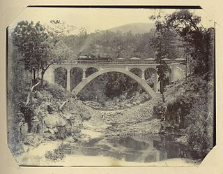
Deep Creek Railway Bridge is also known as Chowey Bridge. It is a heritage-listed railway bridge on the Mungar-Monto railway line in Didcot, North Burnett Region, Queensland, Australia. It was built in 1905 by day labour. It was added to the Queensland Heritage Register on 21 October 1992.

<span class="mw-page-title-main">William Pagan (railway engineer)</span> Australian railway engineer

William Pagan (1849–1924) was a railway engineer in Queensland, Australia. He designed many railway bridges, some of which are now heritage-listed.

<span class="mw-page-title-main">Steep Rocky Creek Railway Bridge</span> Railway bridge in Queensland, Australia.

Steep Rocky Creek Railway Bridge is a heritage-listed railway bridge on the Mungar - Monto railway line at Ideraway in the North Burnett Region of Queensland, Australia. It was designed by William Pagan and built from 1906 to 1907. It was added to the Queensland Heritage Register on 21 October 1992.

<span class="mw-page-title-main">Ideraway Creek Railway Bridge</span> Historic site in Queensland, Australia

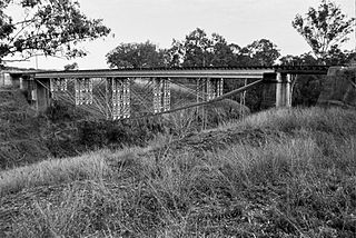
Ideraway Creek Railway Bridge is a heritage-listed railway bridge at Mungar - Monto Line, Ideraway, North Burnett Region, Queensland, Australia. It was designed by William Pagan and built from 1906 to 1907 using day labour. It was added to the Queensland Heritage Register on 21 October 1992.

<span class="mw-page-title-main">Humphery Railway Bridge</span> Historic site in Queensland, Australia

Humphery Railway Bridge is a heritage-listed railway bridge on the Mungar to Monto railway line at Humphery, North Burnett Region, Queensland, Australia. It was designed by William Pagan and built in 1913. It was added to the Queensland Heritage Register on 21 October 1992.

<span class="mw-page-title-main">Binjour</span> Suburb of North Burnett Region, Queensland, Australia

Binjour is a rural locality in the North Burnett Region, Queensland, Australia. In the 2021 census, Binjour had a population of 86 people.

<span class="mw-page-title-main">Kalpowar</span> Town in Queensland, Australia

Kalpowar is a town in the North Burnett Region and a locality split between the North Burnett Region and the Bundaberg Region, in Queensland, Australia. In the 2021 census, the locality of Kalpowar had a population of 53 people.

Gurgeena is a rural locality in the North Burnett Region, Queensland, Australia. In the 2021 census, Gurgeena had a population of 36 people.

<span class="mw-page-title-main">Mount Debateable, Queensland</span> Suburb of North Burnett Region, Queensland, Australia

Mount Debateable is a rural locality in the North Burnett Region, Queensland, Australia. In the 2021 census, Mount Debateable had a population of 40 people.

Boynewood is a rural locality in the North Burnett Region, Queensland, Australia. In the 2021 census, Boynewood had a population of 138 people.

Mount Lawless is a rural locality in the North Burnett Region, Queensland, Australia. In the 2021 census, Mount Lawless had a population of 9 people.

The Boyne Burnett Inland Rail Trail is a recreational route for walkers, cyclists and horse riders from Taragoola to Gayndah. It uses the closed Gladstone to Monto and Mungar Junction to Monto railway corridors in Queensland, Australia.

References

  1. 1 2 3 Australian Bureau of Statistics (28 June 2022). "Dirnbir (SAL)". 2021 Census QuickStats. Retrieved 28 February 2023. OOjs UI icon edit-ltr-progressive.svg
  2. "Dirnbir – locality in North Burnett Region (entry 45343)". Queensland Place Names. Queensland Government . Retrieved 11 June 2019.
  3. 1 2 3 4 5 "Queensland Globe". State of Queensland . Retrieved 25 December 2023.
  4. "Dirnbir – railway station in the North Burnett Region (entry 10179)". Queensland Place Names. Queensland Government . Retrieved 31 July 2019.
  5. "RAILWAY STATIONS". Daily Standard . No. 376. Queensland, Australia. 26 February 1914. p. 2 (SECOND EDITION). Retrieved 31 July 2019 via National Library of Australia.
  6. "Mount Debateable – railway station in the Burnett Region (entry 23010)". Queensland Place Names. Queensland Government . Retrieved 31 July 2019.
  7. "WHAT'S IN A NAME?". The Bundaberg Mail And Burnett Advertiser . Vol. 43, no. 5142. Queensland, Australia. 22 August 1913. p. 2. Retrieved 17 October 2022 via National Library of Australia.
  8. "PUBLIC WORKS TENDERS". The Brisbane Courier . No. 17, 733. Queensland, Australia. 14 November 1914. p. 14. Retrieved 25 December 2023 via National Library of Australia.
  9. "NEW SCHOOLS". The Telegraph . No. 13, 206. Queensland, Australia. 19 March 1915. p. 2. Retrieved 25 December 2023 via National Library of Australia.
  10. Queensland Family History Society (2010), Queensland schools past and present (Version 1.01 ed.), Queensland Family History Society, ISBN   978-1-921171-26-0
  11. "NEW SCHOOLS". The Telegraph . No. 13, 206. Queensland, Australia. 19 March 1915. p. 2. Retrieved 3 September 2023 via National Library of Australia.
  12. "RESERVES PROCLAIMED". The Week . Vol. LXXIX, no. 2, 041. Queensland, Australia. 5 February 1915. p. 4. Retrieved 25 December 2023 via National Library of Australia.
  13. "County of Bowen" (Map). Queensland Government. 1923. Retrieved 25 December 2023.
  14. Australian Bureau of Statistics (27 June 2017). "Dirnbir (SSC)". 2016 Census QuickStats. Retrieved 20 October 2018. OOjs UI icon edit-ltr-progressive.svg
  15. "McConnell Lookout & Park - Renay Robinson Dve, Dirnbir, QLD". poi-australia.com.au. Archived from the original on 15 October 2022. Retrieved 25 October 2022.
  16. RTA News (3 October 2021). "BOYNE BURNETT RAIL TRAIL – OPENING THE DAWES RANGE SECTION". Rail Trails Australia. Archived from the original on 15 October 2022. Retrieved 15 October 2022.
  17. "Mt Debateable to Mundubbera, Burnett River Bridges Section, BBIRT". Boyne Burnett Inland Rail Trail . Archived from the original on 25 September 2022. Retrieved 25 September 2022.
  18. McLachlan, Mark (6 June 2018). "Degilbo to Mundubbera Railway Bridges, 1905 to 1914". Boyne Burnett Inland Rail Trail . Archived from the original on 29 September 2022. Retrieved 25 September 2022.
  19. McGrath, PSM, B. L.; Churchward, Alan (October 2015). "Nomination of the Gayndah Rail Bridges, Queensland for ENGINEERING HERITAGE RECOGNITION under Engineering Heritage Australia's Engineering Heritage Recognition Program" (PDF). Engineers Australia . Archived (PDF) from the original on 25 September 2022. Retrieved 26 September 2022.

Further reading