Humphery Railway Bridge

Last updated

Humphery Railway Bridge
Rail Bridge (Humphery), Gayndah (2002).jpg
Humphery Railway Bridge, 2002
Location Mungar to Monto line, Humphery, North Burnett Region, Queensland, Australia
Coordinates 25°36′54″S151°27′13″E / 25.6151°S 151.4536°E / -25.6151; 151.4536
Design period1900 - 1914 (early 20th century)
Built1913
Architect William Pagan
Official nameRail Bridge (Humphery)
Typestate heritage (built)
Designated21 October 1992
Reference no.600518
Significant period1910s (fabric)
Significant componentspier/s (bridge)
Australia Queensland location map.svg
Red pog.svg
Location of Humphery Railway Bridge in Queensland
Australia location map.svg
Red pog.svg
Humphery Railway Bridge (Australia)

Humphery Railway Bridge is a heritage-listed railway bridge on the Mungar to Monto railway line at Humphery, North Burnett Region, Queensland, Australia. It was designed by William Pagan and built in 1913. It was added to the Queensland Heritage Register on 21 October 1992. [1]

Contents

History

The concrete arch bridge supporting the railway line 2.8 kilometres (1.7  mi ) west of Humphery was constructed in 1913 as the last of several bridges on this line. [1]

A rail link was requested from Maryborough to the long established town of Gayndah in the 1860s, but construction did not begin until the late 1880s. The line opened to Brooweena in July 1889, Boompa in March 1891 and Biggenden in April 1891. Although the rails ended at Degilbo, this section was not opened until 1893 when flood damage to the bridge over the Mary River at Antigua cut off the lime supply for the sugar industry at Maryborough and Bundaberg and a new supply was opened up near Degilbo. The line ended at Degilbo until the extension to Gayndah began with a 32 kilometres (20 mi) extension to Wetheron that opened in December 1905. Gayndah was finally reached in December 1907. In 1910 a further extension was proposed. Construction of the railway between Gayndah and Mundubbera began in April 1911, anticipating by a few months the official turning of the first sod by Walter Paget, Minister for Railways, on 7 July 1911. The line was opened for traffic between Gayndah and Boomerang in November 1913 and to Mundubbera in February 1914. The line was further extended in the 1920s and reached Monto in September 1928. [1]

The use of concrete arches for railway bridges is a distinctive feature in Queensland and South Australia. The first concrete bridge in Queensland was constructed at Petrie Terrace in 1897. Between 1900 and 1913, six arch concrete railway bridges were constructed in Queensland approximating the term in office of William Pagan as Chief Engineer of Railways and it is believed that he was responsible for their design. [2] The first two (Swansons Rail Bridge near Toowoomba and Deep Creek Railway Bridge near Degilbo), followed the form of a stone arch bridge. However, Steep Rocky Creek Railway Bridge in 1906 departs completely from stone forms and has wall type arches supporting vertical diaphragms with a deck slab carrying the track and ballast; this bridge was built to cross a ravine in rugged country and represents a similar design and technical developments to meet similar requirements to that at Humphery, which was completed a few years later. [1]

Description

The bridge is a concrete arch bridge carrying the Mungar to Monto railway over a dry gully some 2.8 kilometres (1.7 mi) south west of Humphrey Station and 14 kilometres (8.7 mi) west of Gayndah. It has five semicircular arch spans, with solid concrete spandrel walls. Although a simple bridge, it is well detailed with projecting cornices at the bases of the arches, attached pillars above the piers extending above the deck and recessed spandrel walls. [1]

The bridge carries a single 3 ft 6 in gauge railway on a ballasted deck. Its spans are 7.9 metres (26  ft ), three at 10.7 metres (35 ft), and 7.9 metres (26 ft) totalling 42.9 metres (141 ft). The solid arch ribs are semicircular, with projecting cornices separating them visually from the piers below. The smaller end spans spring from a higher level, again marked at the pier by a small cornice. The recessed spandrel walls are finished off with the form of concrete slightly patterned to contrast with the smooth finish of the projecting faces of the arches. The railings are of tubular metal between concrete pillars at the piers. [1]

Tourism

The 37.58-kilometre (23.35 mi) Burnett River Bridges section of the Boyne Burnett Inland Rail Trail was opened on 10 September 2022 at Mt Debateable Railway Siding, Mt Debateable Road, Gayndah. [3] Sixteen kilometers of it lies beside the Burnett River. Heading west from the Trail Head the Red Gulley Bridge, Slab Creek Bridge, Spring Creek Bridge, Boomerang Bridge, Humphery Bridges Numbers 1, 2 ("Faith" Bridge or "bridge of faith"), and 3 and Roth's Bridge are passed on the way to the other end at Mundubbera Railway Precinct. [4] The Official Register of Engineering Heritage Markers listed Degilbo-Mundubbera Railway Bridges in October 2016. A total of 12 bridges, including some on this section of Rail Trail, are recognized with one Engineering Heritage Marker representing the “best example of a collection of historic railway bridges in Australia”. [5] [6]

Heritage listing

Humphery Railway Bridge was listed on the Queensland Heritage Register on 21 October 1992 having satisfied the following criteria. [1]

The place is important in demonstrating the evolution or pattern of Queensland's history.

This bridge, which allowed the railway to cross a deep gully, is on a branch line linking early inland towns with Maryborough and demonstrates the way in which Queensland was developed by linking important inland resources with ports. It demonstrates the skill with which the technology of the era was used to solve the problems of climatic conditions and terrain encountered by railway engineers in this process. [1]

The place is important in demonstrating a high degree of creative or technical achievement at a particular period.

This bridge was built to an innovative design with reinforced concrete discontinuous wall-type pinned arches, the second of its type in Australia and only the seventh concrete bridge in Queensland. It was the last of a series of concrete arch bridges built for the Queensland railways between 1900 and 1913 and the third on this line. [1]

The place has a special association with the life or work of a particular person, group or organisation of importance in Queensland's history.

The bridge is an important example of the work of William Pagan, Chief Engineer for Railways and an important figure in the early history of engineering in Queensland. [1]

Engineers Australia listed a total of 12 bridges, including Humphery Railway Bridge, on their Official Register of Engineering Heritage Markers in October 2016. The Degilbo-Mundubbera Railway Bridges are recognized with one Engineering Heritage Marker representing the “best example of a collection of historic railway bridges in Australia”. [5] [6]

Related Research Articles

<span class="mw-page-title-main">Mundubbera</span> Town in Queensland, Australia

Mundubbera is a town and a locality in the North Burnett Region, Queensland, Australia. In the 2016 census, Mundubbera had a population of 1261 people.

<span class="mw-page-title-main">Boyne Valley, Queensland</span> Suburb of Gladstone Region, Queensland, Australia

The Boyne Valley is a rural locality in Gladstone Region, Queensland, Australia. The locality contains four small towns: Nagoorin, Ubobo, Builyan, and Many Peaks. In the 2021 census, Boyne Valley had a population of 301 people.

<span class="mw-page-title-main">Builyan, Queensland</span> Town in Queensland, Australia

Builyan is a town in Gladstone Region, Central Queensland, Australia. It is one of four small townships within the locality of Boyne Valley along with Nagoorin, Ubobo, and Many Peaks.

<span class="mw-page-title-main">Many Peaks, Queensland</span> Town in Queensland, Australia

Many Peaks is a town in Gladstone Region in Queensland, Australia. It is one of four small townships within the locality of Boyne Valley along with Nagoorin, Builyan and Ubobo.

<span class="mw-page-title-main">Mungar Junction to Monto railway line</span> Former railway line in Queensland, Australia

The Mungar Junction to Monto railway line is a 267-kilometre (166 mi) railway in Queensland, Australia. Progressively opened in eleven stages between 1889 and 1928 the line branched from the North Coast line at Mungar Junction a short distance west of Maryborough and followed a westerly route towards Biggenden and Gayndah before turning north via Mundubbera and Eidsvold to Monto. It is also known as the Gayndah Monto Branch Railway. In 2012, the line was officially closed.

Byellee to Monto Branch Railway was a branch railway that branched off the Boyne Valley west of Gladstone in Queensland, Australia.The Boyne Valley region was predominantly a dairying region and a railway had little justification. However a branch was justified in 1906 on the basis of large traffic in timber, fuel, limestone and flexing ores. Progressively opened between 1910 and 1931 the line branched from the North Coast line at Byellee a short distance west of Gladstone and struck a south-westerly route via Many Peaks and Mungungo to Monto.

<span class="mw-page-title-main">Wide Bay–Burnett</span> Region in Queensland, Australia

<span class="mw-page-title-main">Degilbo</span> Town in Queensland, Australia

Degilbo is a rural town and locality in the North Burnett Region, Queensland, Australia. In the 2016 census, the locality of Degilbo had a population of 174 people.

<span class="mw-page-title-main">Ideraway</span> Town in Queensland, Australia

Ideraway is a rural town and locality in the North Burnett Region, Queensland, Australia. In the 2016 census, the locality of Ideraway had a population of 38 people.

<span class="mw-page-title-main">Lockyer Creek Railway Bridge (Lockyer)</span> Historic site in Queensland, Australia

Lockyer Creek Railway Bridge (Lockyer) is a heritage-listed railway bridge on the Toowoomba - Helidon railway line over Lockyer Creek at Lockyer, Lockyer Valley Region, Queensland, Australia. It was designed by William Pagan and built from 1909 to 1910. It was added to the Queensland Heritage Register on 21 October 1992.

<span class="mw-page-title-main">Didcot, Queensland</span> Suburb of North Burnett Region, Queensland, Australia

Didcot is a rural locality in the North Burnett Region, Queensland, Australia. In the 2016 census Didcot had a population of 60 people.

<span class="mw-page-title-main">Deep Creek Railway Bridge</span> Historic site in Queensland, Australia

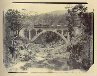
Deep Creek Railway Bridge is also known as Chowey Bridge. It is a heritage-listed railway bridge on the Mungar-Monto railway line in Didcot, North Burnett Region, Queensland, Australia. It was built in 1905 by day labour. It was added to the Queensland Heritage Register on 21 October 1992.

<span class="mw-page-title-main">William Pagan (railway engineer)</span> Australian railway engineer

William Pagan (1849–1924) was a railway engineer in Queensland, Australia. He designed many railway bridges, some of which are now heritage-listed.

<span class="mw-page-title-main">Steep Rocky Creek Railway Bridge</span> Railway bridge in Queensland, Australia.

Steep Rocky Creek Railway Bridge is a heritage-listed railway bridge on the Mungar - Monto railway line at Ideraway in the North Burnett Region of Queensland, Australia. It was designed by William Pagan and built from 1906 to 1907. It was added to the Queensland Heritage Register on 21 October 1992.

<span class="mw-page-title-main">Ideraway Creek Railway Bridge</span> Historic site in Queensland, Australia

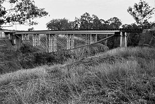
Ideraway Creek Railway Bridge is a heritage-listed railway bridge at Mungar - Monto Line, Ideraway, North Burnett Region, Queensland, Australia. It was designed by William Pagan and built from 1906 to 1907 using day labour. It was added to the Queensland Heritage Register on 21 October 1992.

Humphery is a rural locality in the North Burnett Region, Queensland, Australia. In the 2016 census, Humphery had a population of 34 people.

<span class="mw-page-title-main">Kalpowar</span> Town in Queensland, Australia

Kalpowar is a town in the North Burnett Region and a locality split between the North Burnett Region and the Bundaberg Region, in Queensland, Australia. In the 2016 census, the locality of Kalpowar had a population of 67 people.

Dirnbir is a rural locality in the North Burnett Region, Queensland, Australia. In the 2021 census, Dirnbir had a population of 59 people.

Mount Lawless is a rural locality in the North Burnett Region, Queensland, Australia. In the 2016 census, Mount Lawless had a population of 12 people.

The Boyne Burnett Inland Rail Trail is a recreational route for walkers, cyclists and horse riders from Taragoola to Gayndah. It uses the closed Gladstone to Monto and Mungar Junction to Monto railway corridors in Queensland, Australia.

References

  1. 1 2 3 4 5 6 7 8 9 10 "Rail Bridge (Humphery) (entry 600518)". Queensland Heritage Register . Queensland Heritage Council. Retrieved 1 August 2014.
  2. Queensland State Archives, Bridge 11 Drawing number S4053 (November 2016). "HRP.Degilbo to Mundubbera Railway Bridges.Drawings.Nov 2016.pdf" (PDF). Engineers Australia . p. 10. Retrieved 23 October 2022.{{cite web}}: CS1 maint: numeric names: authors list (link)
  3. RTA News (3 October 2021). "BOYNE BURNETT RAIL TRAIL – OPENING THE DAWES RANGE SECTION". Rail Trails Australia. Retrieved 15 October 2022.
  4. "Mt Debateable to Mundubbera, Burnett River Bridges Section, BBIRT". Boyne Burnett Inland Rail Trail . Retrieved 25 September 2022.
  5. 1 2 McLachlan, Mark (6 June 2018). "Degilbo to Mundubbera Railway Bridges, 1905 to 1914". Boyne Burnett Inland Rail Trail . Retrieved 25 September 2022.
  6. 1 2 McGrath, PSM, B. L.; Churchward, Alan (October 2015). "Nomination of the Gayndah Rail Bridges, Queensland for ENGINEERING HERITAGE RECOGNITION under Engineering Heritage Australia's Engineering Heritage Recognition Program" (PDF). Engineers Australia . pp. 1, 5, 8, 12. Retrieved 26 September 2022.

Attribution

CC-BY-icon-80x15.png This Wikipedia article was originally based on "The Queensland heritage register" published by the State of Queensland under CC-BY 3.0 AU licence (accessed on 7 July 2014, archived on 8 October 2014). The geo-coordinates were originally computed from the "Queensland heritage register boundaries" published by the State of Queensland under CC-BY 3.0 AU licence (accessed on 5 September 2014, archived on 15 October 2014).

Commons-logo.svg Media related to Humphery Railway Bridge at Wikimedia Commons