
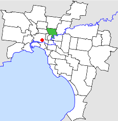
The City of Darebin is a local government area in Victoria, Australia, in the northern suburbs of Melbourne. It has an area of 54 square kilometres (20.8 sq mi) and in June 2018 Darebin had a population of 161,609. Municipal offices are located at 350 High Street, Preston.

Fairfield is an inner suburb in Melbourne, Victoria, Australia, 6 km (3.7 mi) north-east of Melbourne's Central Business District, located within the Cities of Darebin and Yarra local government areas. Fairfield recorded a population of 6,535 at the 2021 census.

Alphington is a suburb in Melbourne, Victoria, Australia, 7 km (4.3 mi) north-east of Melbourne's Central Business District, located within the Cities of Darebin and Yarra local government areas. Alphington recorded a population of 5,702 at the 2021 census.

Northcote is an inner suburb in Melbourne, Victoria, Australia, 6 km (3.7 mi) north-east of Melbourne's Central Business District, located within the City of Darebin local government area. Northcote recorded a population of 25,276 at the 2021 census.

Westgarth railway station is a commuter railway station on the Hurstbridge line, which is part of the Melbourne railway network. It serves the north-eastern suburb of Northcote, in Melbourne, Victoria, Australia. Westgarth station is a ground level unstaffed station, featuring two side platforms. It opened on 8 May 1888.

Darebin railway station is a commuter railway station on the Hurstbridge line, which is part of the Melbourne railway network. It serves the north-eastern suburb of Ivanhoe, in Melbourne, Victoria, Australia. Darebin station is a ground level unstaffed station, featuring two side platforms. It opened on 8 May 1922, with the current station provided in 1977/78 FY.

Proposals for expansion of the Melbourne rail network are commonly presented by political parties, government agencies, industry organisations and public transport advocacy groups. The extensions proposed take a variety of forms: electrification of existing routes to incorporate them into the suburban rail system; reconstruction of former passenger rail lines along pre-existing easements; entirely new routes intended to serve new areas with heavy rail or provide alternative routes in congested areas; or track amplification along existing routes to provide segregation of services. Other proposals are for the construction of new or relocated stations on existing lines, to provide improved access to public transport services.

The Hurstbridge Line is a commuter railway line in the city of Melbourne, Victoria, Australia. Operated by Metro Trains Melbourne, it is the city's seventh longest metropolitan railway line at 36.7 kilometres (22.8 mi). The line runs from Flinders Street Station in central Melbourne to Hurstbridge Station in the north-east, serving 28 stations via Clifton Hill, Heidelberg, Macleod, Greensborough, Eltham and Diamond Creek. The line operates for approximately 19 hours a day with 24 hour service available on Friday and Saturday nights. During peak hour, headways of up to 15 minutes are operated with services every 20–30 minutes during off-peak hours. Trains on the Hurstbridge Line run with a two three-car formations of X'Trapolis 100 trainsets.

The West Gate Freeway is a major freeway in Melbourne, the busiest urban freeway and the busiest road in Australia, carrying upwards of 200,000 vehicles per day. It links Geelong and Melbourne's western suburbs to central Melbourne and beyond. It is also a link between Melbourne and the west and linking industrial and residential areas west of the Yarra River with the city and port areas. The West Gate Bridge is a part of the freeway.

The Eastern Freeway is an urban freeway in eastern Melbourne, the state capital of Victoria, Australia. It is one of the most important freeways in terms of commuting to the city, connecting Alexandra Parade and Hoddle Street in the inner suburbs, with EastLink tollway farther east. It consists of between three and six lanes in each direction, also an inbound transit lane reserved for vehicles with two or more occupants during peak hours.
Greensborough Highway is a highway in the north-eastern suburbs of Melbourne, Australia, and is an important route for north-east Melbourne. This name is not widely known to most drivers, as the entire allocation is still best known as by the names of its constituent parts: Lower Heidelberg Road, Rosanna Road, Lower Plenty Road, Greensborough Road and Greensborough Bypass. This article will deal with the entire length of the corridor for sake of completion.
The City of Northcote was a local government area about 5 kilometres (3 mi) northeast of Melbourne, the state capital of Victoria, Australia. The city covered an area of 17.62 square kilometres (6.80 sq mi), and existed from 1883 until 1994.
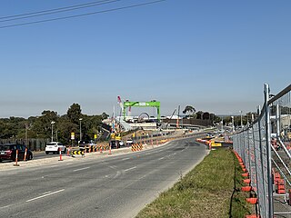
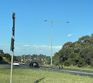
The North East Link is an under construction 10–kilometre tolled highway scheme in Melbourne, Australia. It will connect the Metropolitan Ring Road at Greensborough with the Eastern Freeway at Bulleen, which will be upgraded from Hoddle Street to Springvale Road at Nunawading.

The Main Yarra Trail, also known as the Yarra Trail is a shared-use path for cyclists and pedestrians, which follows the Yarra River through the northeastern suburbs of Melbourne, Victoria, Australia.

The Yarra River is a river in southern Victoria, Australia that flows through the city of Melbourne. There are many parklands, including state parks and national parks, that adjoin the river along its 250 km length. Every park listed has walking tracks, smaller parks usually have unsealed paths, while bigger parks will have sealed pathways suitable for walking and cycling. The Yarra River Trail runs along much of the length of the river's lower reaches through Melbourne. Most parks listed have parking available, the quality and quantity of which varies according to the size of the park. Dogs are not permitted in parklands adjoining the river unless otherwise stated in special off-lead areas.

Bicycle paths around Melbourne are off-road routes for use by people riding bicycles and walking have been developed over many decades. These primarily follow current or former watercourses and major roads to traverse long distances and provide facilities for both transport and recreation.

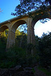
Darebin Creek Bridge is a bluestone masonry arch and concrete road bridge on Heidelberg road Alphington over Darebin Creek. It was built for Heidelberg Road Trust to a design of John C Climie CE and constructed by contractor O. H. Willison in 1864, to replace an earlier 1852 timber bridge which had fallen into a poor state of repair. The bridge was made possible as a result of funds obtained from a toll gate, established on the east side of the Darebin Creek by the Heidelberg Road Trust. The toll keeper was Henry Holloway, and the charges included one farthing for every pig that crossed the bridge and up to eighteen pence for a carriage with four horses.

Doncaster–Eltham Road is a major arterial road in the north-eastern suburbs of Melbourne, Victoria, Australia. This name is not widely known to most drivers, as the entire allocation is still best known as by the names of its constituent parts: Fitzsimons Lane and Williamsons Road. This article will deal with the entire length of the corridor for sake of completion, as well to avoid confusion between declarations.
Heidelberg Road is a major arterial road through the north-eastern suburbs of Melbourne. It was the first road in Victoria outside the township of Melbourne. Heidelberg Road was the main route for people travelling to Heidelberg, from the mid to late 1800s.


