Cougal Spiral

Last updated

Cougal Spiral
Up Brisbane Mail crosses over number 5 spiral tunnel.jpg
The Brisbane Mail crossing over No.1 Spiral Tunnel in 1940
Australia New South Wales relief location map.png
Red pog.svg
Location on the border between New South Wales and Queensland
Overview
Official nameBorder Loop railway formation and landscape
Other name(s)
  • Border Tunnel
  • Border Loop Spiral
  • Cougal To Border Loop
Line North Coast railway line
LocationRichmond Gap connecting New South Wales and Queensland, Australia
Coordinates 28°21′16″S152°57′51″E / 28.354390°S 152.964038°E / -28.354390; 152.964038 Coordinates: 28°21′16″S152°57′51″E / 28.354390°S 152.964038°E / -28.354390; 152.964038
Operation
Opened29 August 1930
Owner Transport Asset Holding Entity
Operator Australian Rail Track Corporation
Technical
LengthA series of three tunnels:
  • 192 metres (630 ft)
  • 177 metres (581 ft)
  • 1,160 metres (3,810 ft)
Track gauge 4 ft 8+12 in (1,435 mm) standard gauge
Grade 1.5%
Route map
1027 - Border Loop railway formation and landscape - SHR Plan No 2651 (5011937b100).jpg
Official nameBorder Loop railway formation and landscape; Cougal To Border Loop; Railway Spiral and Landscape
TypeState heritage (landscape)
Designated2 April 1999
Reference no.1027
TypeHistoric Landscape
CategoryLandscape - Cultural

The Cougal Spiral is a heritage-listed single track railway tunnel and spiral feature of the North Coast railway line in Australia that connects New South Wales with Queensland through Richmond Gap in the Kyogle Council local government area of New South Wales, Australia. It was built during 1930. It is also known as the Border Loop railway formation and landscape, Cougal To Border Loop and Railway Spiral and Landscape. The property was added to the New South Wales State Heritage Register on 2 April 1999. [1]

Contents

The railway line needs to climb at a steady ruling gradient from Kyogle to the summit at a tunnel at the border between the two states. [2] The border is also at the watershed. [3] The rail spiral and associated facilities are located between 871 and 876 kilometres (541 and 544 mi) from Sydney Central railway station. [1]

Description

Climbing almost non-stop at the ruling grade of 1 in 66 or 1.5% (compensated) the line has almost continuous curves of 240 m (790 ft) radius. Near Cougal, the alignment finally runs out of valley, and has nowhere to go. Fortunately a convenient hill allows the line to circle back on itself so that it climbs 30 metres (98 ft) without having to make any forward progress.
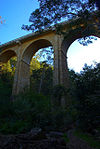
 Soon after the Border Tunnel under the watershed is reached the line descends on the other side. The spiral has two short tunnels, one where it passes under itself, plus another through a small spur in the hillside.

The tunnel at the border summit is approximately 1,600 metres (5,200 ft) long, broken up into three separate tunnels. A lower summit, perhaps without the spiral, would be possible with a considerably longer and more expensive summit tunnel, with the possibility of problems with fumes for both the original steam locomotives and the replacement diesel engines.

The Cougal Spiral is easily viewed from parts of the Lions Road. The structure has been heritage listed due to its historical, scientific and architectural rarity. It opened on 29 August 1930 as part of the extension of the North Coast line from Kyogle to South Brisbane. [2]

The Cougal Railway Spiral and Landscape consists of the following elements: [1]

The spiral is formed by the whole section of line from Cougal to the Border loop. [1]

History

The Border Loop opened on 29 August 1930, connecting NSW and Queensland by rail via Richmond Gap. [1]

Heritage listing

As at 19 July 2013, the Cougal to Border Loop section of the North Coast Line was a notable engineering achievement, revealing a twentieth century engineering solution that allows trains to pass through the steep topography at the NSW/Queensland border. [1]

Border Loop railway formation and landscape was listed on the New South Wales State Heritage Register on 2 April 1999 having satisfied the following criteria. [1]

The place is important in demonstrating the course, or pattern, of cultural or natural history in New South Wales.

The completion of the Cougal to Border Loop section of the North Coast Railway was a major engineering feat in the first half of the twentieth century, being one of several major engineering projects in NSW that allowed continuous railway access between Sydney and Brisbane. [1]

The place is important in demonstrating aesthetic characteristics and/or a high degree of creative or technical achievement in New South Wales.

The combination of tunnels, crossing loops, the underbridge and spiral together form a technically significant example of an innovative and successful railway engineering solution. [1]

The place possesses uncommon, rare or endangered aspects of the cultural or natural history of New South Wales.

The railway spiral at Border Loop is one of only two railway spirals in NSW. [1]

See also

Related Research Articles

Kyogle Town in New South Wales, Australia

Kyogle is a town in the Northern Rivers region of northern New South Wales, Australia. It falls within the local government area of Kyogle Council. At the 2016 census, Kyogle had a population of 2,751 people. Kyogle is known as a "gateway" to many national parks including Border Ranges National Park and Toonumbar National Park.

The Lions Road is a section of the road running between the Summerland Way in New South Wales and the Mount Lindesay Highway near Rathdowney, Queensland at Running Creek. It joins two pre-existing sections of rural road, namely Gradys Creek Road in New South Wales and Running Creek Road in Queensland. It was so named as most of the funding, planning and voluntary labour for the road came from the Kyogle branch of the Lions Club. Kyogle resident Jack Hurley was one of the most prominent advocates of the road. Despite the NSW Government rejecting the idea in 1969, it was opened the following year.

Horseshoe curve Roadbed that turns 180 degrees

A horseshoe curve is a class of climbing curve in a roadbed which reverses turn direction (inflection) twice on either side of a single tight curve that varies through an angle of about 180 degrees or more.

Raurimu Spiral

The Raurimu Spiral is a single-track railway spiral, starting with a horseshoe curve, overcoming a 139-metre (456 ft) height difference, in the central North Island of New Zealand, on the North Island Main Trunk railway (NIMT) between Wellington and Auckland. It is a notable feat of civil engineering, having been called an "engineering masterpiece." The Institute of Professional Engineers of New Zealand has designated the spiral as a significant engineering heritage site.

North Coast railway line, New South Wales Railway line in New South Wales, Australia

The North Coast Line is the primary rail route in the Mid North Coast and Northern Rivers regions of New South Wales, Australia, and forms a major part of the Sydney–Brisbane rail corridor.

Hawkesbury River railway bridge

The Hawkesbury River railway bridge is a heritage-listed railway bridge in New South Wales, Australia that carries the Main North railway line across the Hawkesbury River. It is located just north of the town of Brooklyn on the northern outskirts of Sydney. The railway bridge was to be the last link in a railway network that linked the state capitals Adelaide, Melbourne, Sydney and Brisbane and was a major engineering feat at the time. The original railway bridge was built in 1889 and replaced by the current bridge in 1946. The 1946 bridge was added to the New South Wales State Heritage Register on 2 April 1999.

Kyogle Council Local government area in New South Wales, Australia

Kyogle Council is a local government area in the Northern Rivers region of New South Wales, Australia.

Ten Tunnels Deviation Australian railroad tunnels

The Ten Tunnels Deviation is a heritage-listed 9.2-kilometre (5.7 mi) section of the Main Western Line between Newnes Junction and Zig Zag stations in Lithgow, New South Wales, Australia. It was designed and built by the New South Wales Government Railways and built from 1 June 1908 and 16 October 1910. It is also known as Great Zig Zag Railway deviation tunnels and Bell to Zig Zag Ten Tunnel Railway Deviation. It was added to the New South Wales State Heritage Register on 2 April 1999.

Main Line railway, Queensland

The Main Line is a railway line in South East Queensland, Australia. It was opened in a series of sections between 1865 and 1867. It commences at Roma St Station in Brisbane and extends west 161 km to Toowoomba. It is the first narrow gauge main line constructed in the world. The section of the line from the end of Murphys Creek railway station to the Ruthven Street overbridge, Harlaxton is listed on the Queensland Heritage Register. The Murphys Creek Railway Complex, the Lockyer Creek Railway Bridge (Lockyer), the Lockyer Creek Railway Bridge and Swansons Rail Bridge are also heritage listed.

Upper Canal System

The Upper Canal System, also called the Southern Railway Aqueduct and the Cataract Tunnel, is a heritage-listed operational gravity-fed aqueduct that supplies some of the potable water for Sydney, in New South Wales, Australia. The aqueduct comprises 54 kilometres (34 mi) of open canals, tunnels, and closed pipelines that connect the Upper Nepean Scheme with the Prospect Reservoir. The aqueduct is managed by the Sydney Catchment Authority on behalf of WaterNSW, an agency of the Government of New South Wales. It was listed on the New South Wales State Heritage Register on 18 November 1999.

Murray River railway bridge, Albury–Wodonga

The Murray River railway bridge is a heritage-listed Australian railway bridge over the Murray River on the Main Southern line south of Albury in the City of Albury, New South Wales, and on the North Eastern line north of Wodonga in Victoria. The bridge was designed by John Whitton and built from 1883 to 1884 by J. S. Bennett, with iron work supplied by Westwood, Baillie, England. It is also known as the Rail Bridge over Murray River, Albury-Wodonga and the Albury Lattice Railway Bridge and Murray River Underbridge. The bridge is owned by RailCorp, and maintained by the Australian Rail Track Corporation as part of its lease of the line. It was added to the New South Wales State Heritage Register on 2 April 1999 and added to the Register of the National Estate on 18 April 1989.

Tenterfield Creek railway bridge, Sunnyside

The Tenterfield Creek railway bridge is a heritage-listed former railway bridge that carried the Main North line across the Tenterfield Creek from Sunnyside to Jennings, both in the Tenterfield Shire local government area of New South Wales, Australia. It was designed by John Whitton and Engineer-in-Chief for NSW Government Railways and built in 1888. The bridge is also known as the Sunnyside rail bridge over Tenterfield Creek. The property is owned by RailCorp, an agency of the Government of New South Wales and was added to the New South Wales State Heritage Register on 2 April 1999.

The Manilla railway underbridges are two heritage-listed railway bridges located on the Tamworth-Barraba railway line in the town of Manilla in the Tamworth Regional Council local government area of New South Wales, Australia. The underbridges are owned by RailCorp, an agency of the Government of New South Wales. The two sites were added to the New South Wales State Heritage Register on 2 April 1999.

Long Cove Creek railway viaducts, Lewisham

The Long Cove Creek railway viaducts are heritage-listed railway viaducts which carry the Main Suburban railway line over Long Cove Creek between the suburbs of Lewisham and Summer Hill in Sydney, New South Wales, Australia. The viaducts were designed and built by the New South Wales Government Railways. The property is owned by RailCorp, an agency of the Government of New South Wales. It was added to the New South Wales State Heritage Register on 2 April 1999.

Lithgow Underbridge

The Lithgow Underbridge is a heritage-listed railway underbridge that carries the Main West Line over James Street, in Lithgow, in the City of Lithgow local government area of New South Wales, Australia. The bridge is located approximately 156 kilometres (97 mi) from Central railway station. The bridge was designed by John Whitton as the Engineer-in-Chief for Railways and was built in 1869 by contractor, P. Higgins. It is also known as Lithgow Underbridge. The property is owned by RailCorp, an agency of the Government of New South Wales. It was added to the New South Wales State Heritage Register on 30 August 2013.

Emu Plains Underbridge

Emu Plains Underbridge is a heritage-listed steel truss railway underbridge located off Bruce Neale Dr approximately 1.3 kilometres (0.81 mi) west of the Penrith railway station in the western Sydney suburb of Penrith in the City of Penrith local government area of New South Wales, Australia. It was designed by James Fraser, the existing lines branch and the New South Wales Government Railways. It was built in 1907, with fabrication by R. Tulloch & Co.; and erection by day labour. It is also known as Emu Plains Underbridge and Penrith Underbridge. The property is owned by RailCorp, an agency of the Government of New South Wales. It was added to the New South Wales State Heritage Register on 28 June 2013.

Ultimo Road railway underbridge

The Ultimo Road railway underbridge is a heritage-listed former railway bridge located on the former Darling Harbour goods railway line in the inner city Sydney suburb of Ultimo in the City of Sydney local government area of New South Wales, Australia. It was designed by engineering staff in the Existing Lines branch of the New South Wales Public Works Department and built in 1879. The property is owned by RailCorp, an agency of the Government of New South Wales. It was added to the New South Wales State Heritage Register on 2 April 1999.

Glebe and Wentworth Park railway viaducts

The Glebe and Wentworth Park railway viaducts are a series of two adjacent heritage-listed railway bridges and arch viaducts that carry the Inner West Light Rail across Wentworth Park, Jubilee Park, and Johnstons Creek in the inner western Sydney suburb of Glebe in the City of Sydney local government area of New South Wales, Australia. They were designed by the New South Wales Government Railways and built from 1892 to 1922 by day labour. They are also known as Wentworth Park Viaduct, Jubilee Park Viaduct and Glebe Viaducts. The viaducts were added to the New South Wales State Heritage Register on 2 April 1999.

Railway Square road overbridge

The Railway Square road overbridge is a heritage-listed road overbridge carrying George Street over the former Darling Harbour goods railway line at Railway Square in the Sydney central business district, in the City of Sydney local government area of New South Wales, Australia. The property was added to the New South Wales State Heritage Register on 2 April 1999.

References

  1. 1 2 3 4 5 6 7 8 9 10 "Border Loop railway formation and landscape". New South Wales State Heritage Register . Office of Environment & Heritage. H01027. Retrieved 2 June 2018.
  2. 1 2 "Cougal To Border Loop, Railway Spiral and Landscape". New South Wales State Heritage Register . Office of Environment & Heritage . Retrieved 11 September 2017.
  3. "A Railway Spiral". The Sydney Morning Herald . 24 September 1930. p. 12.

Attribution

CC-BY-icon-80x15.png This Wikipedia article contains material from Border Loop railway formation and landscape , entry number 01027 in the New South Wales State Heritage Register published by the State of New South Wales and Office of Environment and Heritage 2018 under CC-BY 4.0 licence , accessed on 2 June 2018.

Commons-logo.svg Media related to Cougal Spiral (railway) at Wikimedia Commons