Stanwell Creek railway viaduct

Last updated

Stanwell Creek railway viaduct
StanwellBridgeLiss.jpg
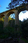
Stanwell Creek railway viaduct, in 2006
Coordinates 34°13′49″S150°58′26″E / 34.2303°S 150.9738°E / -34.2303; 150.9738 Coordinates: 34°13′49″S150°58′26″E / 34.2303°S 150.9738°E / -34.2303; 150.9738
Carries Illawarra line
CrossesStanwell Creek
Locale Stanwell Park, City of Wollongong, New South Wales, Australia
Owner RailCorp
Characteristics
Design Arch viaduct
MaterialBrick
Longest span13.1 metres (43 ft)
No. of spans8
Clearance below 110 feet (34 m)
Rail characteristics
No. of tracks Two
Track gauge 4 ft 8+12 in (1,435 mm) standard gauge
History
Engineering design by NSW Government Railways
Construction start1918
Construction end1920
Official nameStanwell Park Rail Viaduct over Stanwell Creek; Stanwell Creek Viaduct
TypeState heritage (built)
Designated2 April 1999
Reference no.1054
TypeRailway Bridge/ Viaduct
CategoryTransport - Rail
BuildersDay labour
Location
Stanwell Creek railway viaduct

The Stanwell Creek railway viaduct is a heritage-listed railway bridge on the Illawarra railway line at Stanwell Park, City of Wollongong, New South Wales, Australia. It was designed by the New South Wales Government Railways and built in 1920 by day labour. The property is owned by RailCorp, an agency of the Government of New South Wales. It was added to the New South Wales State Heritage Register on 2 April 1999. [1] [2]

Contents

History

The original Illawarra Railway of the 1880s had a difficult transition from the high country near the top of the Illawarra escarpment down to the coastal plain north of Wollongong. It involved steep grades and eight tunnels between Waterfall and Scarborough. The worst was the "suffocating" Otford railway tunnel, the steepest and longest, which emerged into the lower levels of the Stanwell Park amphitheatre. [1]

Plans began around 1910 for duplicating the line with deviations to ease grades and to bypass the old single line tunnels. The section from Waterfall to Helensburgh was completed in 1914, then to Otford in 1915 and on to Coalcliff in 1920. The last section stayed much higher up in the Stanwell Park amphitheatre hence its crossing high above Stanwell Creek. [1]

Plans for the tall, double track, brick arch viaduct were ready in 1917 and work began the next year. It was a remarkable effort to complete this major structure in a little over two years. [1]

Brick arches were the automatic choice because steel was unavailable due to World War I and the State Brickworks at Homebush was in full production. It was still part of the "brick arch era" 1910-24. [1]

It has been estimated that the total number of bricks used in the massive tall piers, the tallest 34 metres (110 ft) high, and the eight arches was around three million, enough to build about 150 brick houses. [1]

The viaduct remained in good condition until 1985 when the arches were found to be on the verge of collapse, at which time remedial work was undertaken. [1]

Description

Located 56.727 kilometres (35.249 mi) from Central station, the bridge consists of a curved brick arch viaduct consisting of eight 13.1-metre (43 ft) clear spans on tall brick piers. [1]

It was reported to currently be in a stable condition as at 17 March 2006. [1]

Major modifications (mainly internal) and the loss of arch span 6, all necessary to save the structure from collapse, have compromised the integrity of the viaduct. However, if long term stability is confirmed, the Rail Authority may consider rebuilding arch span 6. [1]

Modifications and dates

In late 1985, some of the brick arches were on the verge of collapse caused by ground movements associated with the Escarpment and coal mining. The problem was arrested but span 6 was demolished and replaced by a "floating" steel girder so the remaining two parts of the brick arch viaduct could be monitored and plans made for repairs. [1]

In 1992 repairs began under single line working. The closed track was taken up and all material on top of the arches removed then replaced by concrete with embedded layers of reinforcing mesh. Arch action was essentially eliminated. [1]

The track was replaced on a waterproof base and the process repeated for the other track. Work was completed in October 1993 but the steel girder in span 6 remains while long-term monitoring continues. [1]

Heritage listing

This viaduct is one of the most impressive bridge structures in Australia. Its significance to New South Wales is due to it being a major item of infrastructure for the historically important duplication of the Illawarra Railway, its imposing stature high above the creek bed (albeit hidden by trees and bush, its contribution to the enormous social and commercial benefits that railway duplication brought to the Wollongong and Illawarra Regions and the technical skills of building it "up there" and to suit a sharp radius curve. It was the crowning achievement of the "brick arch era" 1910-24 of railway construction in New South Wales. It is the only one of its type and scale in Australia and retains its significance even though emergency work to save it, compromised its integrity. [1]

Stanwell Park Rail Viaduct over Stanwell Creek was listed on the New South Wales State Heritage Register on 2 April 1999 having satisfied the following criteria. [1]

The place is important in demonstrating the course, or pattern, of cultural or natural history in New South Wales.

The Stanwell Creek railway viaduct was the major bridge of the duplication and deviations works on the Illawarra Line 1910-20 between Waterfall and Scarborough. At Stanwell Park, the work kept the new double track line high up in the natural amphitheatre which in turn required a high level crossing of Stanwell Creek. [1]

The place is important in demonstrating aesthetic characteristics and/or a high degree of creative or technical achievement in New South Wales.

The structure is one of the most impressive bridge structures in Australia, eight brick arches sweeping round a sharp railway curve atop brick piers that reach 110 feet (34 m) above the creek bed. [1]

Unfortunately, the view has been lost by the uncontrolled growth of trees and bushland. Only archival photographs give justice to this imposing work. [1]

The place has strong or special association with a particular community or cultural group in New South Wales for social, cultural or spiritual reasons.

The duplication and deviation work on the Illawarra Railway brought enormous social and commercial benefits to the Illawarra Region, which were only achieved through major engineering works such as the Stanwell Creek Viaduct and the five new double-track tunnels. [1]

The place has potential to yield information that will contribute to an understanding of the cultural or natural history of New South Wales.

Constructing the high level Stanwell Creek Viaduct involved two important technical items, building it 110 feet (34 m) above the creek bed and laying the bricks for the arches on a sharp railway curve. [1]

The place possesses uncommon, rare or endangered aspects of the cultural or natural history of New South Wales.

This is only brick arch viaduct of its type and size in Australia. [1]

The place is important in demonstrating the principal characteristics of a class of cultural or natural places/environments in New South Wales.

The viaduct is an excellent example of brick arch construction with the added challenges of height and curvature. [1]

See also

Related Research Articles

Stanwell Park, New South Wales Suburb of Wollongong, New South Wales, Australia

Stanwell Park is a coastal village and northern suburb of Wollongong, New South Wales, Australia. It is the northernmost point of the Illawarra coastal strip and lies south of Sydney's Royal National Park. It is situated in a small valley between Bald Hill to the north, Stanwell Tops to the west and Mount Mitchell to the south. It has two lagoons from the village's two creeks, Stanwell and Hargrave Creeks and a beach running between headlands. Stanwell Park and the surrounding suburbs are colloquially referred to by its postcode 2508.

<span class="mw-page-title-main">South Coast railway line, New South Wales</span> Railway line in New South Wales, Australia

The South Coast Railway is a commuter and goods railway line from Sydney to Wollongong and Bomaderry in New South Wales, Australia. Beginning at the Illawarra Junction, the line services the Illawarra and South Coast regions of New South Wales.

Oatley railway station Railway station in Sydney, New South Wales, Australia

Oatley railway station is a heritage-listed railway station located on the Illawarra line, in the Sydney suburb of Oatley in the Georges River Council local government area of New South Wales, Australia. The station is served by Sydney Trains T4 line services. It was designed and built by the NSW Government Railway and from 1905 to 1992. It is also known as the Oatley Railway Station group. The property was added to the New South Wales State Heritage Register on 2 April 1999.

Otford, New South Wales Suburb of Wollongong, New South Wales, Australia

Otford is a village in the Otford Valley just 55 km to the south of the Sydney metropolitan area and north of the Illawarra and Wollongong in New South Wales, Australia. Otford is within the local government area of Wollongong City Council.

Stanwell Park railway station Railway station in New South Wales, Australia

Stanwell Park railway station is located on the South Coast railway line in New South Wales, Australia. It serves the seaside village of Stanwell Park opening on 23 December 1901, relocating to its current location on 10 October 1920.

South Coast Line Rail service in New South Wales, Australia

The South Coast Line is an intercity rail service operated by NSW TrainLink that services the Illawarra region of New South Wales, Australia. The service runs from Central, and runs the entire length of the eponymous South Coast railway line to Bomaderry. The service also runs along the Eastern Suburbs railway line at peak hours and the Port Kembla railway line to Port Kembla. It is operated with NSW TrainLink H sets and Sydney Trains T sets, with Endeavour railcars operating the service on the non-electrified line between Kiama and Bomaderry.

Wollongong railway station Railway station in New South Wales, Australia

Wollongong railway station is a heritage-listed railway station on the South Coast railway line in New South Wales, Australia. It serves the central business district of Wollongong. It was added to the New South Wales State Heritage Register on 2 April 1999.

Helensburgh railway station Railway station in New South Wales, Australia

Helensburgh railway station is a heritage-listed railway station located on the South Coast railway line in New South Wales, Australia. It serves the town of Helensburgh. It was added to the New South Wales State Heritage Register on 2 April 1999.

Thirroul railway station Railway station in New South Wales, Australia

Thirroul railway station is a heritage-listed railway station on the South Coast railway line in New South Wales, Australia. It serves the northern Wollongong suburb of Thirroul. It was added to the New South Wales State Heritage Register on 2 April 1999.

The Goulburn Viaduct is a heritage-listed railway bridge that carries the Main Southern railway line across the Mulwaree River at Goulburn, in the Goulburn Mulwaree Council local government area of New South Wales, Australia. It was built in 1915. It is also known as Mulwaree River Railway Viaduct. The property is owned by RailCorp, an agency of the Government of New South Wales. It was added to the New South Wales State Heritage Register on 2 April 1999.

The Otford railway tunnel is a heritage-listed former railway tunnel on the Illawarra railway line at Otford, City of Wollongong, New South Wales, Australia. It was designed by the New South Wales Government Railways, and built by W. Rowe and W. Smith (tunnel) and Mr. McDonald. The property was added to the New South Wales State Heritage Register on 2 April 1999.

Lilyvale railway tunnels are heritage-listed railway tunnels on the Illawarra railway line at Lilyvale, City of Wollongong, New South Wales, Australia. It was designed and built by the then-New South Wales Government Railways. The property is owned by RailCorp, an agency of the Government of New South Wales. It was added to the New South Wales State Heritage Register on 2 April 1999.

<span class="mw-page-title-main">Argyle Street railway bridge, Moss Vale</span> Bridge in New South Wales, Australia

The Argyle Street railway bridge is a heritage-listed railway bridge on the Main Southern railway line (146.037 km) at Moss Vale, Wingecarribee Shire, New South Wales, Australia. It was designed and built by the New South Wales Government Railways in 1914 with steel supplied by Dorman Long of Middlesbrough, England. The property is owned by RailCorp, an agency of the Government of New South Wales. It was added to the New South Wales State Heritage Register on 2 April 1999.

<span class="mw-page-title-main">Long Cove Creek railway viaducts, Lewisham</span> Bridge in New South Wales, Australia

The Long Cove Creek railway viaducts are heritage-listed railway viaducts which carry the Main Suburban railway line over Long Cove Creek between the suburbs of Lewisham and Summer Hill in Sydney, New South Wales, Australia. The viaducts were designed and built by the New South Wales Government Railways. The property is owned by RailCorp, an agency of the Government of New South Wales. It was added to the New South Wales State Heritage Register on 2 April 1999.

<span class="mw-page-title-main">Bargo railway viaduct</span> Bridge in New South Wales, Australia

The Bargo Railway Viaduct is a heritage-listed railway viaduct over the Bargo River located on the Main South railway approximately 96 kilometres (60 mi) from Central, in the south-western Sydney settlement of Bargo in the Wollondilly Shire local government area of New South Wales, Australia. The viaduct was designed by New South Wales Government Railways and built in 1919. It is also known as Bargo River Railway Viaduct. The property is owned by RailCorp, an agency of the Government of New South Wales. It was added to the New South Wales State Heritage Register on 2 April 1999.

<span class="mw-page-title-main">Marrangaroo railway viaduct</span> Bridge in New South Wales, Australia

The Marrangaroo railway viaduct is a heritage-listed railway viaduct that carries the Main Western line across Marrangaroo Creek at Marrangaroo in the City of Lithgow local government area of New South Wales, Australia. The property added to the New South Wales State Heritage Register on 2 April 1999.

<span class="mw-page-title-main">Bowenfels rail viaducts</span> Bridge in New South Wales, Australia

The Bowenfels rail viaducts are a series of heritage-listed railway viaducts and railway bridges over Farmers Creek on the Main Western line in Bowenfels, City of Lithgow, New South Wales, Australia. It was designed in two stages, by John Whitton as the Engineer-in-Chief for Railways, in 1870; and by engineering staff of New South Wales Government Railways in 1921; and was built from 1870 to 1921. It is also known as Farmers Creek viaducts. The property is owned by RailCorp, an agency of the Government of New South Wales. It was added to the New South Wales State Heritage Register on 2 April 1999. The viaduct are located approximately 159 kilometres (99 mi) west of Central railway station.

<span class="mw-page-title-main">Coxs River railway bridges, Wallerawang</span> Heritage listed railway bridges in New South Wales

The Coxs River railway bridges are two heritage-listed railway bridges that carry the Main Western line over the Coxs River at Wallerawang, City of Lithgow, New South Wales, Australia. The bridges were designed by engineering staff of the New South Wales Government Railways and built in 1870 by day labour. The property is owned by RailCorp, an agency of the Government of New South Wales. It was added to the New South Wales State Heritage Register on 2 April 1999.

<span class="mw-page-title-main">Rydal rail underbridges</span> Bridge in New South Wales, Australia

The Rydal rail underbridges are a series of heritage-listed railway underbridges and viaducts that carry the Main Western line over Solitary Creek at Rydal, in the City of Lithgow local government area of New South Wales, Australia. The property is owned by RailCorp, an agency of the Government of New South Wales. It was added to the New South Wales State Heritage Register on 2 April 1999.

<span class="mw-page-title-main">Glebe and Wentworth Park railway viaducts</span> Bridge in New South Wales, Australia

The Glebe and Wentworth Park railway viaducts are a series of two adjacent heritage-listed railway bridges and arch viaducts that carry the Inner West Light Rail across Wentworth Park, Jubilee Park, and Johnstons Creek in the inner western Sydney suburb of Glebe in the City of Sydney local government area of New South Wales, Australia. They were designed by the New South Wales Government Railways and built from 1892 to 1922 by day labour. They are also known as Wentworth Park Viaduct, Jubilee Park Viaduct and Glebe Viaducts. The viaducts were added to the New South Wales State Heritage Register on 2 April 1999.

References

  1. 1 2 3 4 5 6 7 8 9 10 11 12 13 14 15 16 17 18 19 20 21 22 "Stanwell Park Rail Viaduct over Stanwell Creek". New South Wales State Heritage Register . Office of Environment & Heritage. H01054. Retrieved 2 June 2018.
  2. "Stanwell Park (Stanwell Creek) Viaduct". New South Wales Heritage Database. Office of Environment and Heritage . Retrieved 15 May 2020.

Bibliography

Attribution

CC BY icon-80x15.png This Wikipedia article was originally based on Stanwell Park Rail Viaduct over Stanwell Creek , entry number 01054 in the New South Wales State Heritage Register published by the State of New South Wales and Office of Environment and Heritage 2018 under CC-BY 4.0 licence , accessed on 2 June 2018.

Commons-logo.svg Media related to Stanwell Park, New South Wales at Wikimedia Commons