Quart Pot Creek Rail Bridge

Last updated

Quart Pot Creek Rail Bridge
Quart Pot Creek Rail Bridge, viewed from upstream, 2015 02.JPG
Quart Pot Creek Rail Bridge, viewed from upstream, 2015
LocationQuart Pot Creek, Stanthorpe, Southern Downs Region, Queensland, Australia
Coordinates 28°39′49″S151°56′29″E / 28.6637°S 151.9414°E / -28.6637; 151.9414
Design period1870s–1890s (late 19th century)
Built1886
Official nameQuart Pot Creek Rail Bridge
Typestate heritage (built)
Designated21 October 1992
Reference no.600829
Significant period1880s (fabric)
Significant componentsabutments – railway bridge, pier/s (bridge)
Australia Queensland location map.svg
Red pog.svg
Location of Quart Pot Creek Rail Bridge in Queensland
Australia location map.svg
Red pog.svg
Quart Pot Creek Rail Bridge (Australia)

Quart Pot Creek Rail Bridge is a heritage-listed railway bridge at Quart Pot Creek, Stanthorpe, Southern Downs Region, Queensland, Australia. It was built in 1886. It is also known as the Red Bridge. It was added to the Queensland Heritage Register on 21 October 1992. [1]

Contents

History

Quart Pot Creek rail bridge, very early 1900s Railway Bridge, Stanthorpe, Qld - very early 1900s.jpg
Quart Pot Creek rail bridge, very early 1900s

The Quart Pot Creek Rail Bridge was constructed in 1886 as part of the former Brisbane–Sydney interstate rail link. [1]

Steam train crossing the railway bridge at Quart Pot Creek Stanthorpe 1917 Steam train crossing the railway bridge at Quart Pot Creek Stanthorpe 1917.tiff
Steam train crossing the railway bridge at Quart Pot Creek Stanthorpe 1917

The major impetus to development in Stanthorpe occurred in 1872 with the start of the practice of alluvial tin mining after discoveries of the valuable metal in the area in the mid 1850s. Stanthorpe became the collective name for two townships (“Quart Pot Creek” and “Stannum”) that grew as a result of the mining boom and became the only centre on the pastoral Darling Downs to develop with mining based revenue. [1]

The Quart Pot Creek Rail Bridge forms part of the Southern railway line (Toowoomba - Warwick- Wallangarra). The line reached Warwick in 1871 and was extended to Stanthorpe to serve the tin industry in 1881. The railway was then extended to the border with New South Wales. The Quart Pot Creek Bridge was built as part of this extension. The original plans were drawn in 1880 and the contract plans were drawn up in 1884. The line opened for traffic between Stanthorpe and Wallangarra, the change of gauge border station, on 4 February 1887. Interstate rail services commenced on 16 January 1888, linking Brisbane with Sydney, Melbourne and Adelaide. Plans to strengthen the 50-foot (15 m) girder spans had first been drawn up in 1904 to permit the operation of heavier locomotives on the Sydney Mail and work began on the Warwick-Wallangarra section in 1910. The No.7 span was braced in 1913 to further accommodate 12-ton axle loads. [1]

Description

Quart Pot Creek Rail Bridge, viewed from downstream, 2015 01 Quart Pot Creek Rail Bridge, viewed from downstream, 2015 01.JPG
Quart Pot Creek Rail Bridge, viewed from downstream, 2015 01

The Quart Pot Creek Rail Bridge comprises 7 50-foot (15 m) spans of 3 rivetted deck type metal double lattice girders supported on six concrete piers and two abutments. It has a total length of 106.7 metres (350 ft). The centre girders, the pier tops and bedplates have been altered. The No.7 span has been braced. The bridge carries a single 1.07-metre (3 ft 6 in) gauge railway. [1]

Plaque, Quart Pot Creek Rail Bridge, 2015 Plaque, Quart Pot Creek Rail Bridge, 2015.JPG
Plaque, Quart Pot Creek Rail Bridge, 2015

A plaque has been added to the bridge to outline its historical significance.

Heritage listing

Quart Pot Creek Rail Bridge was listed on the Queensland Heritage Register on 21 October 1992 having satisfied the following criteria. [1]

The place is important in demonstrating the evolution or pattern of Queensland's history.

The Quart Pot Creek Rail Bridge is an important part of what was formerly the interstate link between Brisbane and Sydney. It is the fourth oldest bridge of its type in Queensland. [1]

The place is important in demonstrating a high degree of creative or technical achievement at a particular period.

The bridge demonstrates a robust engineering design, which has allowed it to be upgraded whilst retaining its essential character. [1]

Related Research Articles

<span class="mw-page-title-main">Stanthorpe, Queensland</span> Town in Queensland, Australia

Stanthorpe is a rural town and locality in the Southern Downs Region, Queensland, Australia. In the 2016 census, Stanthorpe had a population of 5,406 people.

<span class="mw-page-title-main">Wallangarra, Queensland</span> Town in Queensland, Australia

Wallangarra is a rural town and locality in the Southern Downs Region, Queensland, Australia on the border with New South Wales. In the 2016 census, the locality of Wallangarra had a population of 468 people.

Australians generally assumed in the 1850s that railways would be built by the private sector. Private companies built railways in the then colonies of Victoria, opened in 1854, and New South Wales, where the company was taken over by the government before completion in 1855, due to bankruptcy. South Australia's railways were government owned from the beginning, including a horse-drawn line opened in 1854 and a steam-powered line opened in 1856. In Victoria, the private railways were soon found not to be financially viable, and existing rail networks and their expansion were taken over by the colony. Government ownership also enabled railways to be built to promote development, even if not apparently viable in strictly financial terms. The railway systems spread from the colonial capitals, except for a few lines that hauled commodities to a rural port.

<span class="mw-page-title-main">Amiens railway line</span> Branch railway line in the Granite Belt region of Queensland, Australia

The Amiens railway line was a branch railway in the Granite Belt region of Queensland, Australia, branching from the Southern Line at Cottonvale between Warwick and Stanthorpe. The Amiens line was the highest in southern Queensland, with the railway reaching an elevation of 946 metres above sea level at Pozieres.

The Maryvale railway line was a branch railway in the Southern Downs region of Queensland, Australia.

<span class="mw-page-title-main">Southern railway line, Queensland</span> Railway line in Queensland, Australia

The Southern railway line serves the Darling Downs region of Queensland, Australia. The 197-kilometre (122 mi) long line branches from the Western line at Toowoomba, 161 kilometres (100 mi) west of Brisbane, and proceeds south through Warwick and Stanthorpe to the New South Wales/Queensland state border at Wallangarra.

The Mount Edwards railway line was a branch railway in the Scenic Rim region of South East Queensland, Australia. The lines serves a number of small towns in the Fassifern Valley. The first stage of the Mount Edwards line opened from Munbilla to Engelsburg on 17 April 1916, but the next stage to Mount Edwards was not completed until 7 October 1922. The line closed on 1 November 1960.

<span class="mw-page-title-main">Main Line railway, Queensland</span> Railway line in Queensland, Australia

The Main Line is a railway line in South East Queensland, Australia. It was opened in a series of sections between 1865 and 1867. It commences at Roma St Station in Brisbane and extends west 161 km to Toowoomba. It is the first narrow gauge main line constructed in the world. The section of the line from the end of Murphys Creek railway station to the Ruthven Street overbridge, Harlaxton is listed on the Queensland Heritage Register. The Murphys Creek Railway Complex, the Lockyer Creek Railway Bridge (Lockyer), the Lockyer Creek Railway Bridge and Swansons Rail Bridge are also heritage listed.

<span class="mw-page-title-main">Sadliers Crossing Railway Bridge</span> Historic site in Queensland, Australia

Sadliers Crossing Railway Bridge is a heritage-listed railway bridge at over Bremer River between Tallon Street, Sadliers Crossing and Dixon Street, Wulkuraka, Queensland, Australia on the Main Line (this section is now the Ipswich and Rosewood railway line. It was added to the Queensland Heritage Register on 13 November 2008.

<span class="mw-page-title-main">Wallangarra railway station</span> Historic site in Queensland, Australia

Wallangarra railway station is a heritage-listed railway station at Woodlawn Street, Wallangarra, Southern Downs Region, Queensland, Australia. It was built in 1877 along the state border of Queensland and New South Wales It was added to the Queensland Heritage Register on 28 March 2003.

<span class="mw-page-title-main">Cherry Gully Tunnel</span> Historic site in Queensland, Australia

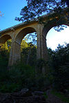
Cherry Gully Tunnel is a heritage-listed railway tunnel on the Warwick–Stanthorpe Line, Silverwood, Southern Downs Region, Queensland, Australia. It was built from 1878 to 1880 by J & A Overend & Co. It is also known as Gorge Tunnel and Big Tunnel. It was added to the Queensland Heritage Register on 28 July 2000.

<span class="mw-page-title-main">Dalveen Tunnel</span> Historic site in Queensland, Australia

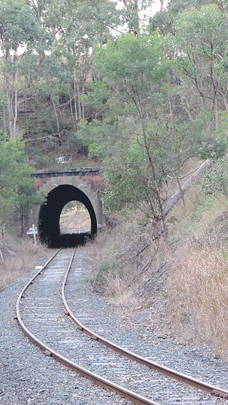
Dalveen Tunnel is a heritage-listed tunnel on the Warwick to Wallangarra railway line, Dalveen, Southern Downs Region, Queensland, Australia. It was built from 1878 to 1880 by J Garget. It was added to the Queensland Heritage Register on 28 July 2000.

<span class="mw-page-title-main">Warwick railway station, Queensland</span> Historic site in Queensland, Australia

Warwick railway station is a heritage-listed railway station on the Southern railway line in Warwick, Southern Downs Region, Queensland, Australia. It was built from c. 1881 to 1910s. It was added to the Queensland Heritage Register on 24 September 1999.

<span class="mw-page-title-main">Stanthorpe railway station</span> Railway station in Queensland, Australia

Stanthorpe railway station is located on the Southern line in Queensland, Australia, serving the town of Stanthorpe.

<span class="mw-page-title-main">Lockyer Creek Railway Bridge (Clarendon)</span> Historic site in Queensland, Australia

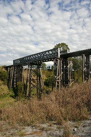
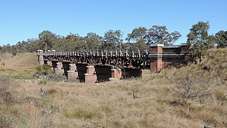
Lockyer Creek Railway Bridge is a heritage-listed railway bridge on the Brisbane Valley railway line over Lockyer Creek at Clarendon, Somerset Region, Queensland, Australia. It was designed by Henry Charles Stanley and built from 1885 to 1886 by H A Brigg. It was added to the Queensland Heritage Register on 21 October 1992.

<span class="mw-page-title-main">Woolooga Rail Bridge</span> Heritage listed railway bridge in Queensland, Australia

Woolooga Rail Bridge is a heritage-listed railway bridge at Wide Bay Creek on the Theebine - Kilikivan railway line, Woolooga, Gympie Region, Queensland, Australia. It was built in 1884 by Owen McDermott & Co. It was added to the Queensland Heritage Register on 21 October 1992.

<span class="mw-page-title-main">Angellala Rail Bridge</span> Historic site in Queensland, Australia

Angellala Rail Bridge is a heritage-listed railway bridge on the Roma-Cunnamulla railway line over Angellala Creek in Sommariva in the Shire of Murweh, Queensland, Australia. It was designed by Henry Charles Stanley and built from c. 1885 to 1994. It was added to the Queensland Heritage Register on 21 October 1992.

<span class="mw-page-title-main">Tenterfield Creek railway bridge, Sunnyside</span> Bridge in New South Wales, Australia

The Tenterfield Creek railway bridge is a heritage-listed former railway bridge that carried the Main North Line across the Tenterfield Creek from Sunnyside to Jennings, both in the Tenterfield Shire local government area of New South Wales, Australia. It was designed by John Whitton and Engineer-in-Chief for NSW Government Railways and built in 1888. The bridge is also known as the Sunnyside rail bridge over Tenterfield Creek. The property is owned by Transport Asset Holding Entity, an agency of the Government of New South Wales and was added to the New South Wales State Heritage Register on 2 April 1999.

Sugarloaf is a rural locality in the Southern Downs Region, Queensland, Australia. In the 2016 census, Sugarloaf had a population of 113 people.

References

  1. 1 2 3 4 5 6 7 8 "Quart Pot Creek Rail Bridge (entry 600829)". Queensland Heritage Register . Queensland Heritage Council. Retrieved 1 August 2014.

Attribution

CC-BY-icon-80x15.png This Wikipedia article was originally based on "The Queensland heritage register" published by the State of Queensland under CC-BY 3.0 AU licence (accessed on 7 July 2014, archived on 8 October 2014). The geo-coordinates were originally computed from the "Queensland heritage register boundaries" published by the State of Queensland under CC-BY 3.0 AU licence (accessed on 5 September 2014, archived on 15 October 2014).

Commons-logo.svg Media related to Quart Pot Creek Rail Bridge at Wikimedia Commons