Burdekin Bridge | |
---|---|
Coordinates | 19°38′25″S147°23′41″E / 19.6404°S 147.3946°E |
Carries | Bruce Highway Motor vehicles, Railway |
Crosses | Burdekin River |
Locale | between the towns of Ayr and Home Hill, Queensland, Australia |
Other name(s) | Burdekin River Bridge or the Silver Link |
Preceded by | Inkerman Bridge |
Characteristics | |
Design | Truss bridge |
Material | Steel |
Total length |
|
Longest span | 250 feet (76.2 m) |
No. of spans | 10 main spans and 22 approach spans [2] |
Piers in water | 9 |
History | |
Designer | Harry Lowe, Noel Ullman, Bill Hansen |
Construction start | April 1947 |
Construction end | 1957 |
Opened | 27 March 1957 [3] [4] [5] |
Statistics | |
Daily traffic | 7000 |
Toll | No |
Location | |
The Burdekin Bridge (known as the Burdekin River Bridge or Silver Link) [6] spans the Burdekin River between the towns of Ayr (locality of McDesme) to the north and Home Hill to the south, both in the Shire of Burdekin, Queensland, Australia. Located on the Bruce Highway which is part of Highway 1, it is an important link in the national road network. It is a road-rail bridge which provides high flood immunity link between north and south Queensland. [1]
The Bridge was completed in 1957. Construction began 10 years earlier in 1947. [7] At 3,620 feet (1,103 m) in length, it is one of the longest multi-span bridges in Australia and longer than Brisbane's Story Bridge or New South Wales's Hawkesbury River Railway Bridge. It is 46 metres shorter than Sydney's Harbour Bridge. [1] [8] It is the only bridge in Australia to be built on sand. [6]
Prior to the construction of the high-level Burdekin Bridge, there were two low-level bridges over the Burdekin River, one for road and one for rail. These bridges were frequently impassable due to flooding of the river. [5] Remnants of the old rail bridge can be seen immediately downstream of the present bridge. [9] [10]
Originally, it was thought that the bridge could not be built in its present location. No trace of rock could be found on which to build the bridge foundations. In 1946, two high-ranking Government engineers visited India to inspect a number of bridges built on sand foundations. The same technique was used for the Burdekin Bridge and it is the only bridge in Australia not built with a firm foothold.
The bridge rests on 11 huge, hollow, concrete caissons sunk into the river bed. The caissons are 17 metres across the top (measured parallel to the stream) and vary in width from 5.5 to 7.6 metres. The caissons were sunk into the river bed to a depth of about 30 metres. Add to that the approximately 20 metres that the caissons rise above the bed and the result is some very massive pieces of concrete. Each weighs about 4,000 tons. The caissons were fitted with steel "cutting edges" to help them sink. The steel used in the cutting edges weighed 238 tons.
Construction of the first caisson started in 1947 after the "wet season". As each caisson rose in height, sand was removed from the centre of the caisson to make it sink into the sand bed. To get such a tremendous mass to sink gradually and evenly was difficult. To add to the difficulties, often a caisson became stuck and a diver had to be sent down to find the problem and remedy it. Another difficulty was that each caisson had to be sunk to a secure depth before the "wet season". If a caisson was not firmly anchored deep enough, a flood could have swept it away.
Because the bridge does not have rock foundations but is entirely supported by sand, it is sometimes described as a floating bridge. It is not a true floating bridge as it does not float on water.
The metal bridge spans were bolted together with high-tensile bolts instead of being riveted. At the time, no other Australian bridge had ever been constructed this way.
With all the difficulties, plus the shortage of steel after World War II, the construction took almost a decade to complete at a cost of $6 million. The bridge officially opened on 27 March 1957. [11] Despite these setbacks, the new bridge greatly assisted in travel between Ayr, Queensland and Home Hill, Queensland and formed a vital link between North and South Queensland.
The Silver Link replaced the Inkerman Bridge which is set just above the river bed. It was regularly covered and washed away by flood waters but it is still possible to see the remains of the old bridge when the river level is low.
Due to the special construction of the bridge, with steel beams forming a truss over the highway, it is regularly being closed to let pass oversize loads which take both lanes on the narrow bridge.
In October 2010, the Burdekin Bridge was recognised as a National Engineering Heritage Landmark. [6] [5]
A 5-year bridge maintenance and rehabilitation project had commenced in 2013. It is the first major structural rehabilitation work undertaken since the bridge construction. [1] This maintenance and rehabilitation program is continuing in July 2022, with an expected total cost of $96.9 million. [12]
The bridge was listed as an Engineering Heritage National Landmark by Engineers Australia as part of its Engineering Heritage Recognition Program. [13]
The William Jolly Bridge is a heritage-listed road bridge over the Brisbane River between North Quay in the Brisbane central business district and Grey Street in South Brisbane, within City of Brisbane, Queensland, Australia. It was designed by Harding Frew and built from 1928 to 1932 by MR Hornibrook.
Albert Bridge is a heritage-listed railway bridge of steel truss design crossing the Brisbane River between Indooroopilly and Chelmer in the City of Brisbane, Queensland, Australia. It was designed by Henry Charles Stanley and built from 1894 to 1895 by John McCormick & Son as a replacement for an earlier bridge lost to flooding in 1893. Both bridges were named in honour of the Prince of Wales, Prince Albert. It was added to the Queensland Heritage Register on 21 October 1992.
The Burdekin River is a river in North and Far North Queensland, Australia. The river rises on the northern slopes of Boulder Mountain at Valley of Lagoons, part of the western slope of the Seaview Range, and flows into the Coral Sea at Upstart Bay over 200 kilometres (124 mi) to the southeast of the source, with a catchment area of approximately 130,000 square kilometres (50,000 sq mi). The Burdekin River is Australia's largest river by (peak) discharge volume.
Ayr is a rural town and locality in the Shire of Burdekin, Queensland, Australia. It is the centre of a sugarcane-growing region and the administrative centre for the Burdekin Shire Council. In the 2016 census, the locality of Ayr had a population of 8,738 people.
The Barkly Highway is a national highway in Queensland and the Northern Territory in Australia. It is the only sealed road between Queensland and the Northern Territory.
Home Hill is a rural town and locality in the Shire of Burdekin, Queensland, Australia. In the 2016 census, the locality of Home Hill had a population of 2,954 people.
Wallaville is a rural town and locality in the Bundaberg Region, Queensland, Australia. It is 372 kilometres (231 mi) north of the state capital, Brisbane and 43 kilometres (27 mi) south west of the regional centre of Bundaberg. In the 2016 census, Wallaville had a population of 410 people.
Meghna Bridge is a road bridge in Bangladesh. It was built with the assistance of Japan and officially named Japan Bangladesh Friendship Bridge 1, but it is popularly known as Meghna Bridge. According to a study conducted in 2004 by the Embassy of Japan in Bangladesh, residents living around the Meghna Bridge recognized several positive impacts after the construction of the bridge.
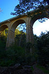
Dickabram Bridge is a heritage-listed road-and-rail bridge over the Mary River between Miva and Theebine, both in the Gympie Region, Queensland, Australia. It was the major bridge on the Kingaroy railway line. It was designed by Henry Charles Stanley and built from 1885 to 1886 by Messrs Michael McDermott, Owens & Co. It is also known as Mary River Bridge (Miva). The bridge was registered on the former Register of the National Estate in 1988.
The Peats Ferry Bridge is a steel truss bridge that carries the Pacific Highway (B83) across the Hawkesbury River, between Kangaroo Point and Mooney Mooney Point, located 40 kilometres (25 mi) north of Sydney in New South Wales, Australia. The bridge carries the Hornsby to Kariong section of highway, while the adjacent Brooklyn Bridge carries the Pacific Motorway (M1).
The Great Northern Railway is a 1067 mm gauge railway line in Queensland, Australia. The line stretches nearly 1,000 kilometres linking the port city of Townsville, Australia to the mining town of Mount Isa in north-west Queensland. Along with a passenger service called the Inlander, it is a major freight route connecting the Mount Isa Mines to the Port of Townsville. In 2010, the line moved 5.8 million tonnes of cargo, and this is expected to increase significantly in coming years.
Breddan is a rural locality in the Charters Towers Region, Queensland, Australia. In the 2016 census, Breddan had a population of 485 people.
Osborne is a rural locality in the Shire of Burdekin, Queensland, Australia. In the 2016 census Osborne had a population of 273 people.
McDesme is a rural locality in the Shire of Burdekin, Queensland, Australia. In the 2016 census McDesme had a population of 277 people.
Rita Island is a coastal and rural locality in the Shire of Burdekin, Queensland, Australia. In the 2016 census, Rita Island had a population of 152 people.
Horseshoe Lagoon is a rural locality in the Shire of Burdekin, Queensland, Australia. In the 2021 census, Horseshoe Lagoon had a population of 213 people.
Cromarty is a rural locality in the Shire of Burdekin, Queensland, Australia. In the 2021 census, Cromarty had a population of 43 people.
Mona Park is a rural locality in the Shire of Burdekin, Queensland, Australia. In the 2021 census, Mona Park had a population of 97 people.
Burdekin may refer to:
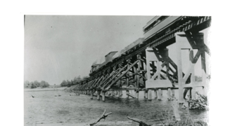
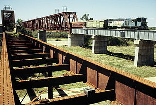
The Inkerman Bridge was a railway bridge over the Burdekin River between McDesme and Home Hill, both in the Shire of Burdekin, Queensland, Australia. It was in operation between 1913 and 1957 after which it was replaced by the Burdekin Bridge.