
The Shire of Burdekin is a local government area located in North Queensland, Australia in the Dry Tropics region. The district is located between Townsville and Bowen in the delta of the Burdekin River. The shire covers an area of 5,044 square kilometres (1,947 sq mi). It has existed as a local government entity since 1888. In the 2021 census, the Shire of Burdekin had a population of 16,692 people.

The Burdekin River is a river in North and Far North Queensland, Australia. The river rises on the northern slopes of Boulder Mountain at Valley of Lagoons, part of the western slope of the Seaview Range, and flows into the Coral Sea at Upstart Bay over 200 kilometres (124 mi) to the southeast of the source, with a catchment area of approximately 130,000 square kilometres (50,000 sq mi). The Burdekin River is Australia's largest river by (peak) discharge volume.

Ayr is a rural town and locality in the Shire of Burdekin, Queensland, Australia. It is the centre of a sugarcane-growing region and the administrative centre for the Burdekin Shire Council. In the 2021 census, the locality of Ayr had a population of 8,603 people.

Giru is a town and coastal locality in the Shire of Burdekin, Queensland, Australia, situated on the Haughton River, 54 kilometres (34 mi) south-east of Townsville. In the 2021 census, the locality of Giru had a population of 387 people.

Home Hill is a rural town and locality in the Shire of Burdekin, Queensland, Australia. In the 2021 census, the locality of Home Hill had a population of 2,876 people.

The Burdekin Bridge spans the Burdekin River between the towns of Ayr to the north and Home Hill to the south, both in the Shire of Burdekin, Queensland, Australia. Located on the Bruce Highway which is part of Highway 1, it is an important link in the national road network. It is a road-rail bridge which provides high flood immunity link between north and south Queensland.

Inkerman is a rural town and locality in the Shire of Burdekin, Queensland, Australia. In the 2021 census, the locality of Inkerman had a population of 119 people.
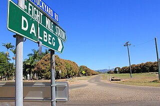
Dalbeg is a rural town and locality in the Shire of Burdekin, Queensland, Australia. In the 2021 census, the locality of Dalbeg had a population of 32 people.
Brandon is a rural town and locality in the Shire of Burdekin, Queensland, Australia. In the 2021 census, the locality of Brandon had a population of 1,088 people.
Millaroo is a rural town and locality in the Shire of Burdekin, Queensland, Australia. In the 2021 census, the locality of Millaroo had a population of 86 people.
Majors Creek is a locality split between the City of Townsville and the Shire of Burdekin, Queensland, Australia. In the 2021 census, Majors Creek had a population of 327 people.

Airville is a rural locality in the Shire of Burdekin, Queensland, Australia. In the 2021 census, Airville had a population of 308 people.
Fredericksfield is a rural locality in the Shire of Burdekin, Queensland, Australia. In the 2021 census, Fredericksfield had a population of 259 people.
Horseshoe Lagoon is a rural locality in the Shire of Burdekin, Queensland, Australia. In the 2021 census, Horseshoe Lagoon had a population of 213 people.
Kirknie is a rural locality in the Shire of Burdekin, Queensland, Australia. In the 2021 census, Kirknie had a population of 70 people.
Groper Creek is a coastal town and rural locality in the Shire of Burdekin, Queensland, Australia. In the 2021 census, the locality of Groper Creek had a population of 66 people.

Cromarty is a rural locality in the Shire of Burdekin, Queensland, Australia. In the 2021 census, Cromarty had a population of 43 people.
Mona Park is a rural locality in the Shire of Burdekin, Queensland, Australia. In the 2021 census, Mona Park had a population of 97 people.
Mount Kelly is a rural locality in the Shire of Burdekin, Queensland, Australia. In the 2021 census, Mount Kelly had a population of 291 people.
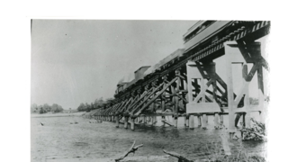
The Inkerman Bridge was a railway bridge over the Burdekin River between McDesme and Home Hill, both in the Shire of Burdekin, Queensland, Australia. It was in operation between 1913 and 1957 after which it was replaced by the Burdekin Bridge.


