Clare, Queensland

Last updated

Clare
Queensland
Australia Queensland location map.svg
Red pog.svg
Clare
Coordinates 19°47′05″S147°13′38″E / 19.7847°S 147.2272°E / -19.7847; 147.2272 (Clare (town centre))
Population196 (2016 census locality) [1]
 • Density1.709/km2 (4.426/sq mi)
Postcode(s) 4807
Area114.7 km2 (44.3 sq mi)
Time zone AEST (UTC+10:00)
Location
LGA(s) Shire of Burdekin
State electorate(s) Burdekin
Federal division(s) Dawson
Localities around Clare:
Upper Haughton Upper Haughton Mona Park
Mulgrave Clare Kirknie
Mulgrave Kirknie Kirknie

Clare is a rural town and locality in the Shire of Burdekin, Queensland, Australia. [2] [3] In the 2016 census the locality of Clare had a population of 196 people. [1]

Contents

Geography

Clare is low-lying flat land (approx 20 metres about sea level). The Burdekin River forms the locality's eastern boundary. The land is used to grow sugarcane growing area and there is a network of cane tramways to transport the harvested sugarcane to the local sugar mills. The town is located in the east of the locality, near but not beside the river. [4]

The Clare Solar Farm was established in 2018 and is located in Clare.

History

The town was originally named Mulgrave, but was changed by Surveyor-General to Clare on 20 July 1882. [2]

A Burdekin receiving office was open by 1879. It was renamed Culburra in 1880. It became Mulgrave Post Office later that year, then Clare Post Office in 1882. It had closed by 1916. [5]

Clare State School opened on 8 February 1950. [6]

At the 2006 census, Clare had a population of 410. [7]

In the 2016 census the locality of Clare had a population of 196 people. [1]

Education

Clare State School with old school in the background, circa 1952 Queensland State Archives 4801 Clare State School with old school in the background Burdekin Shire c 1952.png
Clare State School with old school in the background, circa 1952

Clare State School is a government primary (Prep-6) school for boys and girls at Larkin Street ( 19°47′00″S147°13′36″E / 19.7832°S 147.2268°E / -19.7832; 147.2268 (Clare State School) ). [8] [9] In 2016, the school had an enrolment of 23 students with 2 teachers and 5 non-teaching staff (2 full-time equivalent). [10] In 2018, the school had an enrolment of 19 students with 2 teachers (1 full-time equivalent) and 6 non-teaching staff (3 full-time equivalent). [11]

There is no secondary school in Clare. The nearest secondary school is Home Hill State High School in Home Hill to the north-east. [4]

Related Research Articles

<span class="mw-page-title-main">Gordonvale, Queensland</span> Town in Queensland, Australia

Gordonvale is a rural sugar-growing town and locality situated on the southern side of Cairns in the Cairns Region, Queensland, Australia. In the 2021 census, the locality of Gordonvale had a population of 6,944 people.

<span class="mw-page-title-main">Ayr, Queensland</span> Town in Queensland, Australia

Ayr is a rural town and locality in the Shire of Burdekin, Queensland, Australia. It is the centre of a sugarcane-growing region and the administrative centre for the Burdekin Shire Council. In the 2016 census, the locality of Ayr had a population of 8,738 people.

<span class="mw-page-title-main">Giru, Queensland</span> Town in Queensland, Australia

Giru is a town and coastal locality in the Shire of Burdekin, Queensland, Australia, situated on the Haughton River, 54 kilometres (34 mi) south-east of Townsville. In the 2016 census, the locality of Giru had a population of 354 people.

<span class="mw-page-title-main">Home Hill, Queensland</span> Town in Queensland, Australia

Home Hill is a rural town and locality in the Shire of Burdekin, Queensland, Australia. In the 2016 census, the locality of Home Hill had a population of 2,954 people.

<span class="mw-page-title-main">Aloomba, Queensland</span> Town in Queensland, Australia

Aloomba is a town and a locality in the Cairns Region, Queensland, Australia. In the 2016 census, Aloomba had a population of 529 people.

<span class="mw-page-title-main">Inkerman, Queensland</span> Town in Queensland, Australia

Inkerman is a rural town and locality in the Shire of Burdekin, Queensland, Australia. In the 2016 census, the locality of Inkerman had a population of 145 people.

<span class="mw-page-title-main">Dalbeg, Queensland</span> Town in Queensland, Australia

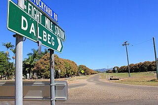
Dalbeg is a rural town and locality in the Shire of Burdekin, Queensland, Australia. In the 2016 census, Dalbeg had a population of 76 people.

Brandon is a rural town and locality in the Shire of Burdekin, Queensland, Australia. In the 2016 census, Brandon had a population of 1,094 people.

Millaroo is a rural town and locality in the Shire of Burdekin, Queensland, Australia. In the 2016 census, the locality of Millaroo had a population of 96 people.

<span class="mw-page-title-main">Abergowrie, Queensland</span> Suburb of Shire of Hinchinbrook, Queensland, Australia

Abergowrie is a rural town and locality in the Shire of Hinchinbrook, Queensland, Australia. In the 2016 census, Abergowrie had a population of 438 people.

<span class="mw-page-title-main">Bloomfield, Queensland</span> Suburb of Shire of Cook, Queensland, Australia

Bloomfield is a town in the Shire of Cook and a coastal locality which is split between the Shire of Cook and the Shire of Douglas in Queensland, Australia. The neighbourhood of Ayton is within the locality. In the 2016 census, Bloomfield had a population of 204 people.

Majors Creek is a locality split between the City of Townsville and the Shire of Burdekin, Queensland, Australia. In the 2016 census, Majors Creek had a population of 329 people.

<span class="mw-page-title-main">Fishery Falls, Queensland</span> Suburb of Cairns Region, Queensland, Australia

Fishery Falls is a locality in the Cairns Region, Queensland, Australia. In the 2021 census, Fishery Falls had a population of 205 people.

<span class="mw-page-title-main">Airville, Queensland</span> Suburb of Shire of Burdekin, Queensland, Australia

Airville is a rural locality in the Shire of Burdekin, Queensland, Australia. In the 2016 census, Airville had a population of 338 people.

<span class="mw-page-title-main">Jarvisfield, Queensland</span> Suburb of Shire of Burdekin, Queensland, Australia

Jarvisfield is a coastal rural locality in the Shire of Burdekin, Queensland, Australia. In the 2016 census Jarvisfield had a population of 367 people.

Osborne is a rural locality in the Shire of Burdekin, Queensland, Australia. In the 2016 census Osborne had a population of 273 people.

<span class="mw-page-title-main">Rita Island, Queensland</span> Suburb of Shire of Burdekin, Queensland, Australia

Rita Island is a coastal and rural locality in the Shire of Burdekin, Queensland, Australia. In the 2016 census, Rita Island had a population of 152 people.

Kirknie is a rural locality in the Shire of Burdekin, Queensland, Australia. In the 2021 census, Kirknie had a population of 70 people.

Groper Creek is a coastal town and rural locality in the Shire of Burdekin, Queensland, Australia. In the 2016 census, Groper Creek had a population of 62 people.

Carstairs is a rural locality in the Shire of Burdekin, Queensland, Australia. In the 2021 census, Carstairs had a population of 91 people.

References

  1. 1 2 3 Australian Bureau of Statistics (27 June 2017). "Clare (SSC)". 2016 Census QuickStats. Retrieved 20 October 2018. OOjs UI icon edit-ltr-progressive.svg
  2. 1 2 "Clare – town in Shire of Burdekin (entry 40984)". Queensland Place Names. Queensland Government . Retrieved 26 December 2020.
  3. "Clare – locality in Shire of Burdekin (entry 42283)". Queensland Place Names. Queensland Government . Retrieved 26 December 2020.
  4. 1 2 "Queensland Globe". State of Queensland . Retrieved 3 February 2021.
  5. Premier Postal History. "Post Office List". Premier Postal Auctions. Archived from the original on 15 May 2014. Retrieved 10 May 2014.
  6. Queensland Family History Society (2010), Queensland schools past and present (Version 1.01 ed.), Queensland Family History Society, ISBN   978-1-921171-26-0
  7. Australian Bureau of Statistics (25 October 2007). "Clare (Burdekin Shire) (State Suburb)". 2006 Census QuickStats. Retrieved 5 May 2011.
  8. "State and non-state school details". Queensland Government. 9 July 2018. Archived from the original on 21 November 2018. Retrieved 21 November 2018.
  9. "Clare State School". Archived from the original on 18 March 2020. Retrieved 21 November 2018.
  10. "Annual Report 2016" (PDF). Clare State School. Archived from the original (PDF) on 4 October 2017. Retrieved 4 October 2017.
  11. "ACARA School Profile 2018". Australian Curriculum, Assessment and Reporting Authority. Archived from the original on 27 August 2020. Retrieved 28 January 2020.