
Wunjunga is a coastal locality in the Shire of Burdekin in Queensland, Australia. In the 2021 census, Wunjunga had a population of 13 people.

Inkerman is a rural town and locality in the Shire of Burdekin, Queensland, Australia. In the 2021 census, the locality of Inkerman had a population of 119 people.
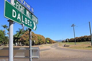
Dalbeg is a rural town and locality in the Shire of Burdekin, Queensland, Australia. In the 2021 census, the locality of Dalbeg had a population of 32 people.
Millaroo is a rural town and locality in the Shire of Burdekin, Queensland, Australia. In the 2021 census, the locality of Millaroo had a population of 86 people.

Byfield is a rural locality in the Shire of Livingstone, Queensland, Australia. In the 2021 census, the locality of Byfield had a population of 323 people.
Minnamoolka is a locality in the Tablelands Region, Queensland, Australia. In the 2021 census, Minnamoolka had a population of 27 people.
Airdmillan is a coastal locality in the Shire of Burdekin, Queensland, Australia. In the 2021 census, Airdmillan had a population of 154 people.
Dumpy Creek is a rural locality in the Shire of Banana, Queensland, Australia. In the 2021 census, Dumpy Creek had a population of 16 people.
Orient is a coastal locality in the Shire of Hinchinbrook, Queensland, Australia. In the 2021 census, Orient had "no people or a very low population".
Jerona is a rural town and coastal locality in the Shire of Burdekin, Queensland, Australia. In the 2021 census, the locality of Jerona had a population of 41 people.
Barratta is a rural town and a locality in the Shire of Burdekin, Queensland, Australia. In the 2021 census, the locality of Barratta had a population of 85 people.
Horseshoe Lagoon is a rural locality in the Shire of Burdekin, Queensland, Australia. In the 2021 census, Horseshoe Lagoon had a population of 213 people.
Carstairs is a rural locality in the Shire of Burdekin, Queensland, Australia. In the 2021 census, Carstairs had a population of 91 people.
Cambridge is a locality in the Shire of Richmond, Queensland, Australia. In the 2021 census, Cambridge had "no people or a very low population".
Stockyard is a coastal locality in the Livingstone Shire, Queensland, Australia. The town of Stockyard Point is located within the locality. In the 2021 census, Stockyard had a population of 16 people.
Shoalwater is a coastal locality in the Livingstone Shire, Queensland, Australia. In the 2021 census, Shoalwater had "no people or a very low population".
Weerriba is a rural locality in the Livingstone Shire, Queensland, Australia. In the 2021 census, Weerriba had "no people or a very low population".
Barwidgi is a rural locality in the Shire of Mareeba, Queensland, Australia. In the 2021 census, Barwidgi had "no people or a very low population".
Munderra is a rural locality in the Shire of Mareeba, Queensland, Australia. In the 2021 census, Munderra had "no people or a very low population".

Springfield is a rural locality in the Shire of Mareeba, Queensland, Australia. In the 2021 census, Springfield had a population of 14 people.
