Millaroo Queensland | |||||||||||||||
---|---|---|---|---|---|---|---|---|---|---|---|---|---|---|---|
![]() Burdekin River at Millaroo | |||||||||||||||
Coordinates | 20°03′25″S147°16′48″E / 20.0569°S 147.28°E | ||||||||||||||
Population | 86 (2021 census) [1] | ||||||||||||||
• Density | 1.490/km2 (3.860/sq mi) | ||||||||||||||
Postcode(s) | 4807 | ||||||||||||||
Elevation | 50 m (164 ft) [2] | ||||||||||||||
Area | 57.7 km2 (22.3 sq mi) | ||||||||||||||
Time zone | AEST (UTC+10:00) | ||||||||||||||
Location |
| ||||||||||||||
LGA(s) | Shire of Burdekin | ||||||||||||||
State electorate(s) | Burdekin | ||||||||||||||
Federal division(s) | Kennedy | ||||||||||||||
| |||||||||||||||
|
Millaroo is a rural town and locality in the Shire of Burdekin, Queensland, Australia. [4] [5] In the 2021 census, the locality of Millaroo had a population of 86 people. [1]
The locality is bounded to the west by the Burdekin River. [6] The place is located about 100 kilometres (62 mi) south-east of Townsville, about 50 kilometres (31 mi) inland from the Coral Sea.
It is a sugarcane growing area with underground water supplies to irrigate crops. [6]
Millaroo has a dry-winter humid subtropical climate, bordering on a tropical savannah climate (Köppen: Cwa/Aw). The town experiences a short wet season from December to March and a long dry season from April to October with cooler nights and higher sunshine. Average maxima vary from 33.4 °C (92.1 °F) in November and December to 25.5 °C (77.9 °F) in July, while average minima fluctuate between 22.6 °C (72.7 °F) in January and 9.9 °C (49.8 °F) in July. Mean average annual precipitation is moderate: 843.3 mm (33.20 in); but is highly concentrated during the summer; and is spread across 57.2 precipitation days (above the 1.0 mm (0.039 in) threshold). Extreme temperatures have ranged from 44.4 °C (111.9 °F) on 13 February 1969 to −0.7 °C (30.7 °F) on 24 June 1984. [7]
Climate data for Millaroo (20º03'00"S, 147º16'12"E, 45 m AMSL) (1965-1993 normals and extremes, rainfall to 1958) | |||||||||||||
---|---|---|---|---|---|---|---|---|---|---|---|---|---|
Month | Jan | Feb | Mar | Apr | May | Jun | Jul | Aug | Sep | Oct | Nov | Dec | Year |
Record high °C (°F) | 42.2 (108.0) | 44.4 (111.9) | 39.7 (103.5) | 36.5 (97.7) | 33.0 (91.4) | 32.2 (90.0) | 31.0 (87.8) | 36.4 (97.5) | 37.5 (99.5) | 38.7 (101.7) | 43.7 (110.7) | 42.0 (107.6) | 44.4 (111.9) |
Mean daily maximum °C (°F) | 33.1 (91.6) | 32.5 (90.5) | 31.7 (89.1) | 30.2 (86.4) | 27.9 (82.2) | 25.8 (78.4) | 25.5 (77.9) | 27.5 (81.5) | 29.8 (85.6) | 31.8 (89.2) | 33.4 (92.1) | 33.4 (92.1) | 30.2 (86.4) |
Mean daily minimum °C (°F) | 22.6 (72.7) | 22.4 (72.3) | 20.9 (69.6) | 17.9 (64.2) | 15.0 (59.0) | 11.0 (51.8) | 9.9 (49.8) | 11.6 (52.9) | 13.8 (56.8) | 16.9 (62.4) | 20.3 (68.5) | 21.8 (71.2) | 17.0 (62.6) |
Record low °C (°F) | 15.7 (60.3) | 17.0 (62.6) | 13.2 (55.8) | 8.3 (46.9) | 3.3 (37.9) | −0.7 (30.7) | 0.0 (32.0) | 0.5 (32.9) | 4.0 (39.2) | 8.9 (48.0) | 12.7 (54.9) | 14.4 (57.9) | −0.7 (30.7) |
Average precipitation mm (inches) | 190.7 (7.51) | 168.8 (6.65) | 128.5 (5.06) | 48.9 (1.93) | 45.9 (1.81) | 20.4 (0.80) | 15.7 (0.62) | 10.4 (0.41) | 8.5 (0.33) | 25.6 (1.01) | 55.0 (2.17) | 127.4 (5.02) | 843.3 (33.20) |
Average precipitation days (≥ 1.0 mm) | 9.4 | 10.3 | 8.3 | 4.6 | 3.7 | 2.1 | 1.8 | 1.4 | 1.1 | 2.7 | 4.6 | 7.2 | 57.2 |
Mean monthly sunshine hours | 229.4 | 200.6 | 220.1 | 222.0 | 223.2 | 234.0 | 251.1 | 266.6 | 273.0 | 297.6 | 285.0 | 257.3 | 2,959.9 |
Percentage possible sunshine | 56 | 56 | 58 | 64 | 64 | 71 | 73 | 75 | 76 | 76 | 73 | 62 | 67 |
Source: Bureau of Meteorology (1965-1993 normals and extremes, rainfall to 1958) [3] |
The name Millaroo comes from Millaroo Creek, which in turn was recorded by surveyor Robert Abbott in 1895, but the original of that name are unknown. There was a pastoral property of that name. [4] [8]
Following World War II, a number of soldier settlement blocks were established in the area for the purpose of growing tobacco, but it was not successful. [9]
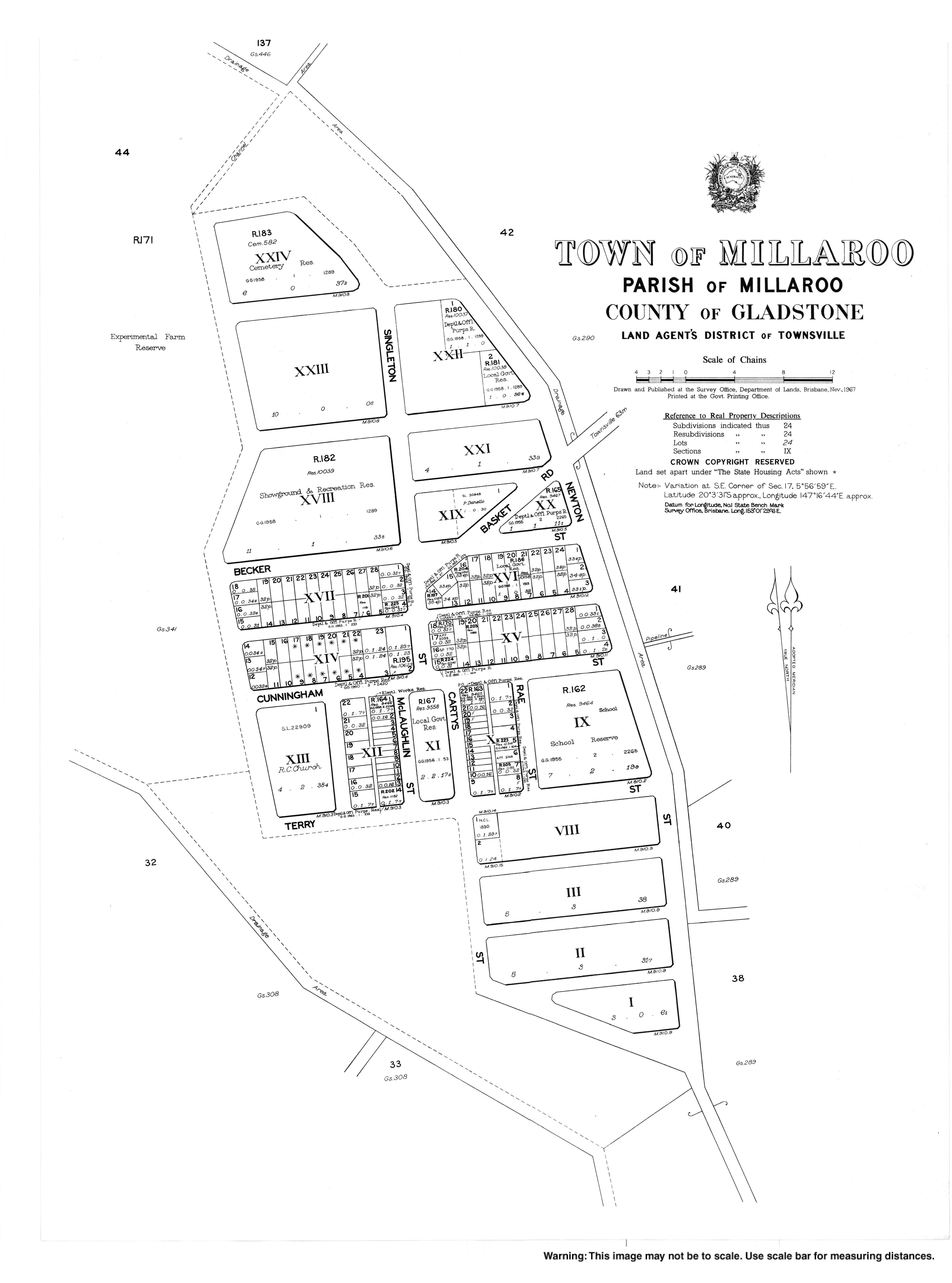
In 1952, there was a plan to establish a new irrigation area along the Burdekin River based around a new town. The town to be called Millaroo was to be established as a "modern" "first class" planned town with reserves, parks, and industrial zones suitable for a population of 6,000 (a similar population to that of Ayr at that time). The buildings were to be constructed with brick and concrete to reduce the fire risk. [8] [10] [11]
In 1952, the Millaroo Research Station was established by the Queensland Department of Agriculture and Stock to undertake agricultural research to benefit North Queensland. [9]
The Burdekin Gorge Weir ( 20°28′21″S147°17′26″E / 20.4726°S 147.2905°E ) on the Burdekin River (between Ravenswood and Mount Wyatt) was completed in November 1953 to provide water for irrigation. [12] This led to the land at Millaroo switching to growing sugarcane. [9]
Millaroo State School opened on 19 July 1954. [13] [14]
Millaroo Post Office opened on 1 July 1955 and closed in 1972. [15]
In the 2011 census, the locality of Millaroo had a population of 200 people. [16]
In the 2016 census, the locality of Millaroo had a population of 96 people. [17]
In the 2021 census, the locality of Millaroo had a population of 86 people. [1]
Millaroo State School is a government primary (Early Childhood-6) school for boys and girls at 1-13 Cunningham Street ( 20°03′29″S147°16′50″E / 20.0581°S 147.2806°E ). [18] [19] [6] In 2018, the school had an enrolment of 9 students with 3 teachers (2 full-time equivalent) and 6 non-teaching staff (2 full-time equivalent). [20]
There are no secondary schools in Millaroo. The nearest government secondary school is Home Hill State High School in Home Hill to the north-east, but, given the distance, the alternatives are distance education or boarding schools. [6]