Fredericksfield

Last updated

Map all coordinates using: OpenStreetMap
Fredericksfield
Queensland
Australia Queensland location map.svg
Red pog.svg
Fredericksfield
Coordinates 19°44′19″S147°24′19″E / 19.7387°S 147.4052°E / -19.7387; 147.4052 (Fredericksfield (centre of locality))
Population219 (2016 census) [1]
 • Density2.139/km2 (5.539/sq mi)
Postcode(s) 4806
Area102.4 km2 (39.5 sq mi)
Time zone AEST (UTC+10:00)
LGA(s) Shire of Burdekin
State electorate(s) Burdekin
Federal division(s) Dawson
Suburbs around Fredericksfield:
Osborne Home Hill Inkerman
Kirknie Fredericksfield Inkerman
Kirknie Wangaratta Wangaratta

Fredericksfield is a rural locality in the Shire of Burdekin, Queensland, Australia. [2] In the 2016 census Fredericksfield had a population of 219 people. [1]

Contents

Geography

The locality is bounded to the east by the North Coast railway line. [3] There were a number of railway stations serving the locality but all are now abandoned: [4]

History

Iyah State School opened on 6 September 1920. In 1945 there were complaints of overcrowding with 44 students enrolled and an average attendance of 38 students and only one teacher. The school closed on 31 December 1963. [5] [6] [7] It was located at 13 Charlies Hill Road ( 19°42′37″S147°26′57″E / 19.7102°S 147.4491°E / -19.7102; 147.4491 (Iyah State School (former)) ). [8]

In the 2016 census Fredericksfield had a population of 219 people. [1]

Related Research Articles

<span class="mw-page-title-main">Shire of Burdekin</span> Local government area in Queensland, Australia

The Shire of Burdekin is a local government area located in North Queensland, Australia in the Dry Tropics region. The district is located between Townsville and Bowen in the delta of the Burdekin River.

<span class="mw-page-title-main">Ayr, Queensland</span> Town in Queensland, Australia

Ayr is a rural town and locality in the Shire of Burdekin, Queensland, Australia. It is the centre of a sugarcane-growing region and the administrative centre for the Burdekin Shire Council. In the 2016 census, the locality of Ayr had a population of 8,738 people.

<span class="mw-page-title-main">Greenvale, Queensland</span> Town in Queensland, Australia

Greenvale is a rural town and locality in the Charters Towers Region, Queensland, Australia. In the 2016 census, the locality of Greenvale had a population of 232 people.

<span class="mw-page-title-main">Giru, Queensland</span> Town in Queensland, Australia

Giru is a town and coastal locality in the Shire of Burdekin, Queensland, Australia, situated on the Haughton River, 54 kilometres (34 mi) south-east of Townsville. In the 2016 census, the locality of Giru had a population of 354 people.

<span class="mw-page-title-main">Home Hill, Queensland</span> Town in Queensland, Australia

Home Hill is a rural town and locality in the Shire of Burdekin, Queensland, Australia. In the 2016 census, the locality of Home Hill had a population of 2,954 people.

<span class="mw-page-title-main">Inkerman, Queensland</span> Town in Queensland, Australia

Inkerman is a rural town and locality in the Shire of Burdekin, Queensland, Australia. In the 2016 census, the locality of Inkerman had a population of 145 people.

<span class="mw-page-title-main">Dalbeg, Queensland</span> Town in Queensland, Australia

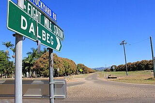
Dalbeg is a rural town and locality in the Shire of Burdekin, Queensland, Australia. In the 2016 census, Dalbeg had a population of 76 people.

<span class="mw-page-title-main">Ravenswood, Queensland</span> Town in Queensland, Australia

Ravenswood is a rural town and locality in the Charters Towers Region, Queensland, Australia. In the 2016 census, the locality of Ravenswood had a population of 255 people.

Clare is a rural town and locality in the Shire of Burdekin, Queensland, Australia. In the 2016 census the locality of Clare had a population of 196 people.

Brandon is a rural town and locality in the Shire of Burdekin, Queensland, Australia. In the 2016 census, Brandon had a population of 1,094 people.

Millaroo is a rural town and locality in the Shire of Burdekin, Queensland, Australia. In the 2016 census, the locality of Millaroo had a population of 96 people.

Majors Creek is a locality split between the City of Townsville and the Shire of Burdekin, Queensland, Australia. In the 2016 census, Majors Creek had a population of 329 people.

<span class="mw-page-title-main">Airville, Queensland</span> Suburb of Shire of Burdekin, Queensland, Australia

Airville is a rural locality in the Shire of Burdekin, Queensland, Australia. In the 2016 census, Airville had a population of 338 people.

<span class="mw-page-title-main">Jarvisfield, Queensland</span> Suburb of Shire of Burdekin, Queensland, Australia

Jarvisfield is a coastal rural locality in the Shire of Burdekin, Queensland, Australia. In the 2016 census Jarvisfield had a population of 367 people.

Osborne is a rural locality in the Shire of Burdekin, Queensland, Australia. In the 2016 census Osborne had a population of 273 people.

McDesme is a rural locality in the Shire of Burdekin, Queensland, Australia. In the 2016 census McDesme had a population of 277 people.

<span class="mw-page-title-main">Rita Island, Queensland</span> Suburb of Shire of Burdekin, Queensland, Australia

Rita Island is a coastal and rural locality in the Shire of Burdekin, Queensland, Australia. In the 2016 census, Rita Island had a population of 152 people.

Horseshoe Lagoon is a rural locality in the Shire of Burdekin, Queensland, Australia. In the 2021 census, Horseshoe Lagoon had a population of 213 people.

<span class="mw-page-title-main">Cromarty, Queensland</span> Suburb of Shire of Burdekin, Queensland, Australia

Cromarty is a rural locality in the Shire of Burdekin, Queensland, Australia. In the 2021 census, Cromarty had a population of 43 people.

Mount Kelly is a rural locality in the Shire of Burdekin, Queensland, Australia. In the 2016 census, Mount Kelly had a population of 280 people.

References

  1. 1 2 3 Australian Bureau of Statistics (27 June 2017). "Fredericksfield (SSC)". 2016 Census QuickStats. Retrieved 20 October 2018. OOjs UI icon edit-ltr-progressive.svg
  2. "Fredericksfield – locality in Shire of Burdekin (entry 42287)". Queensland Place Names. Queensland Government . Retrieved 26 December 2020.
  3. "Queensland Globe". State of Queensland . Retrieved 31 December 2020.
  4. "Railway stations and sidings - Queensland". Queensland Open Data. Queensland Government. 2 October 2020. Archived from the original on 5 October 2020. Retrieved 5 October 2020.
  5. "Agency ID 6177, Iyah State School". Queensland State Archives . Retrieved 19 February 2021.
  6. Queensland Family History Society (2010), Queensland schools past and present (Version 1.01 ed.), Queensland Family History Society, ISBN   978-1-921171-26-0
  7. "SMALL FARMS SEEK SUGAR ASSIGNMENT". Townsville Daily Bulletin . Vol. LXVII. Queensland, Australia. 28 June 1945. p. 2. Retrieved 19 February 2021 via National Library of Australia.
  8. "Ayr (eastern)" (Map). Queensland Government. 1942. Retrieved 19 February 2021.