Carstairs, Queensland

Last updated

Carstairs
Queensland
Australia Queensland location map.svg
Red pog.svg
Carstairs
Coordinates 19°39′02″S147°27′09″E / 19.6505°S 147.4525°E / -19.6505; 147.4525 (Carstairs (centre of locality))
Population91 (SAL 2021) [1]
Postcode(s) 4806
Area36.0 km2 (13.9 sq mi)
Time zone AEST (UTC+10:00)
Location
LGA(s) Shire of Burdekin
State electorate(s) Burdekin
Federal division(s) Dawson
Suburbs around Carstairs:
McDesme Jarvisfield Rita Island
Home Hill Carstairs Rita Island
Home Hill Inkerman Inkerman

Carstairs is a rural locality in the Shire of Burdekin, Queensland, Australia. [2] In the 2021 census, Carstairs had a population of 91 people. [3]

Contents

Geography

The Burdekin River forms the northern and eastern boundaries of the locality. [4] The land use is predominantly growing sugarcane which is processed at the Inkerman Sugar Mill in neighbouring Home Hill. [5]

The mill operates a cane tramway network to transport the sugarcane to the mill. [5]

History

The locality was named and bounded on 23 February 2001. [2]

Demographics

In the 2016 census, Carstairs had a population of 117 people. [6]

In the 2021 census, Carstairs had a population of 91 people. [3]

Education

There are no school in Carstairs. The nearest government primary and secondary schools are Home Hill State School and Home Hill State High School, both in neighbouring Home Hill to the west. [5]

Related Research Articles

<span class="mw-page-title-main">Home Hill, Queensland</span> Town in Queensland, Australia

Home Hill is a rural town and locality in the Shire of Burdekin, Queensland, Australia. In the 2016 census, the locality of Home Hill had a population of 2,954 people.

<span class="mw-page-title-main">Tinbeerwah, Queensland</span> Suburb of Shire of Noosa, Queensland, Australia

Tinbeerwah is a semi-rural locality in the Shire of Noosa, Queensland, Australia. In the 2021 census, Tinbeerwah had a population of 1,160 people.

<span class="mw-page-title-main">Inkerman, Queensland</span> Town in Queensland, Australia

Inkerman is a rural town and locality in the Shire of Burdekin, Queensland, Australia. In the 2016 census, the locality of Inkerman had a population of 145 people.

<span class="mw-page-title-main">Dalbeg, Queensland</span> Town in Queensland, Australia

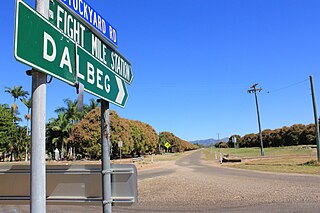
Dalbeg is a rural town and locality in the Shire of Burdekin, Queensland, Australia. In the 2016 census, Dalbeg had a population of 76 people.

Clare is a rural town and locality in the Shire of Burdekin, Queensland, Australia. In the 2016 census the locality of Clare had a population of 196 people.

Brandon is a rural town and locality in the Shire of Burdekin, Queensland, Australia. In the 2016 census, Brandon had a population of 1,094 people.

<span class="mw-page-title-main">Millaroo, Queensland</span> Town in Queensland, Australia

Millaroo is a rural town and locality in the Shire of Burdekin, Queensland, Australia. In the 2016 census, the locality of Millaroo had a population of 96 people.

<span class="mw-page-title-main">Taranganba</span> Town in Queensland, Australia

Taranganba is a town and locality in the Livingstone Shire, Queensland, Australia. In the 2016 census, the locality of Taranganba had a population of 2,276 people.

Richmond is a suburb of Mackay in the Mackay Region, Queensland, Australia. In the 2016 census Richmond had a population of 486 people.

<span class="mw-page-title-main">Airville, Queensland</span> Suburb of Shire of Burdekin, Queensland, Australia

Airville is a rural locality in the Shire of Burdekin, Queensland, Australia. In the 2016 census, Airville had a population of 338 people.

<span class="mw-page-title-main">Jarvisfield, Queensland</span> Suburb of Shire of Burdekin, Queensland, Australia

Jarvisfield is a coastal rural locality in the Shire of Burdekin, Queensland, Australia. In the 2016 census Jarvisfield had a population of 367 people.

Osborne is a rural locality in the Shire of Burdekin, Queensland, Australia. In the 2016 census Osborne had a population of 273 people.

Mount Surround is a rural locality in the Shire of Burdekin, Queensland, Australia. In the 2016 census Mount Surround had a population of 145 people.

<span class="mw-page-title-main">Rita Island, Queensland</span> Suburb of Shire of Burdekin, Queensland, Australia

Rita Island is a coastal and rural locality in the Shire of Burdekin, Queensland, Australia. In the 2016 census, Rita Island had a population of 152 people.

Colevale is a coastal locality in the Shire of Burdekin, Queensland, Australia. In the 2021 census, Colevale had a population of 19 people.

<span class="mw-page-title-main">Newell, Queensland</span> Town in Queensland, Australia

Newell is a coastal town and rural locality in the Shire of Douglas, Queensland, Australia. It is a sugarcane growing district.

Clara Creek is a locality in the Shire of Murweh, Queensland, Australia. In the 2021 census, Clara Creek had a population of 56 people.

Bilyana is a coastal locality in the Cassowary Coast Region, Queensland, Australia. In the 2021 census, Bilyana had a population of 190 people.

<span class="mw-page-title-main">Lower Daintree, Queensland</span> Suburb of Shire of Douglas, Queensland, Australia

Lower Daintree is a coastal rural locality in the Shire of Douglas, Queensland, Australia. In the 2021 census, Lower Daintree had a population of 83 people.

Garrawalt is a rural locality in the Shire of Hinchinbrook, Queensland, Australia.

References

  1. Australian Bureau of Statistics (28 June 2022). "Carstairs (Suburb and Locality)". Australian Census 2021 QuickStats. Retrieved 28 June 2022.  OOjs UI icon edit-ltr-progressive.svg
  2. 1 2 "Carstairs – locality in Shire of Burdekin (entry 42282)". Queensland Place Names. Queensland Government . Retrieved 18 November 2018.
  3. 1 2 Australian Bureau of Statistics (28 June 2022). "Carstairs (SAL)". 2021 Census QuickStats. Retrieved 28 February 2023. OOjs UI icon edit-ltr-progressive.svg
  4. Google (14 August 2021). "Carstairs, Queensland" (Map). Google Maps . Google. Retrieved 14 August 2021.
  5. 1 2 3 "Queensland Globe". State of Queensland . Retrieved 28 August 2023.
  6. Australian Bureau of Statistics (27 June 2017). "Carstairs (SSC)". 2016 Census QuickStats. Retrieved 20 October 2018. OOjs UI icon edit-ltr-progressive.svg