
The Shire of Burdekin is a local government area located in North Queensland, Australia in the Dry Tropics region. The district is located between Townsville and Bowen in the delta of the Burdekin River. The shire covers an area of 5,044 square kilometres (1,947 sq mi). It has existed as a local government entity since 1888. In the 2021 census, the Shire of Burdekin had a population of 16,692 people.

Inkerman is a rural town and locality in the Shire of Burdekin, Queensland, Australia. In the 2021 census, the locality of Inkerman had a population of 119 people.
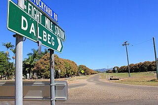
Dalbeg is a rural town and locality in the Shire of Burdekin, Queensland, Australia. In the 2021 census, the locality of Dalbeg had a population of 32 people.
Clare is a rural town and locality in the Shire of Burdekin, Queensland, Australia. In the 2021 census, the locality of Clare had a population of 201 people.
Brandon is a rural town and locality in the Shire of Burdekin, Queensland, Australia. In the 2021 census, the locality of Brandon had a population of 1,088 people.
Millaroo is a rural town and locality in the Shire of Burdekin, Queensland, Australia. In the 2021 census, the locality of Millaroo had a population of 86 people.
Minnamoolka is a locality in the Tablelands Region, Queensland, Australia. In the 2021 census, Minnamoolka had a population of 27 people.

Airville is a rural locality in the Shire of Burdekin, Queensland, Australia. In the 2021 census, Airville had a population of 308 people.
Jarvisfield is a coastal rural locality in the Shire of Burdekin, Queensland, Australia. In the 2021 census, Jarvisfield had a population of 343 people.
Osborne is a rural locality in the Shire of Burdekin, Queensland, Australia. In the 2021 census, Osborne had a population of 245 people.
Pheasant Creek is a rural locality in the Shire of Banana, Queensland, Australia. In the 2021 census, Pheasant Creek had a population of 48 people.
Mount Surround is a rural locality in the Shire of Burdekin, Queensland, Australia. In the 2021 census, Mount Surround had a population of 130 people.
Rangemore is a rural locality in the Shire of Burdekin, Queensland, Australia. In the 2021 census, Rangemore had "no people or a very low population".
Fredericksfield is a rural locality in the Shire of Burdekin, Queensland, Australia. In the 2021 census, Fredericksfield had a population of 259 people.

Alva is a coastal town and a locality in the Shire of Burdekin, Queensland, Australia. In the 2021 census, the locality of Alva had a population of 214 people.
Colevale is a coastal locality in the Shire of Burdekin, Queensland, Australia. In the 2021 census, Colevale had a population of 19 people.
Jerona is a rural town and coastal locality in the Shire of Burdekin, Queensland, Australia. In the 2021 census, the locality of Jerona had a population of 41 people.
Horseshoe Lagoon is a rural locality in the Shire of Burdekin, Queensland, Australia. In the 2021 census, Horseshoe Lagoon had a population of 213 people.
Eight Mile Creek is a rural locality in the Shire of Burdekin, Queensland, Australia. In the 2021 census, Eight Mile Creek had "no people or a very low population".
Carstairs is a rural locality in the Shire of Burdekin, Queensland, Australia. In the 2021 census, Carstairs had a population of 91 people.
