Dickabram Bridge

Last updated

Dickabram Bridge
Dickabram Bridge59.JPG
Dickabram Bridge over the Mary River
Coordinates 25°57′14″S152°29′43″E / 25.9540°S 152.4954°E / -25.9540; 152.4954
CarriesMotor vehicles, Railway
Crosses Mary River
Locale Miva, Queensland
Heritage status Registered (ID 15956)
Characteristics
Design Truss bridge
Material Timber, Steel
Height3.5 metres (11 ft) maximum vehicle height [1]
Longest span36.6 metres (120 ft)
No. of spans14 (6.1m, 7.9m, three at 11m, 11.6m, 24.1m, 36.6m, 24.1m, 11.6m, two at 11m, 7.9m and 6.1m)
Clearance above 4.3 metres (14 ft)
Clearance below 23 metres (75 ft)
History
Designer Henry Charles Stanley
Constructed byMcDermott Owen & Co.
Construction start1885
Construction end6 December 1886
Location
Dickabram Bridge
Dickabram Bridge
Australia Queensland location map.svg
Red pog.svg
Location of Dickabram Bridge in Queensland
Locationacross the Mary River, between Miva and Theebine, Gympie Region, Queensland, Australia
Coordinates 25°57′14″S152°29′44″E / 25.9538°S 152.4956°E / -25.9538; 152.4956
Design period1870s - 1890s (late 19th century)
Built1885 - 1886
Architect Henry Charles Stanley
Official nameDickabram Bridge, Mary River Bridge (Miva)
Typestate heritage (built)
Designated21 October 1992
Reference no.600836
Significant period1880s (fabric)
Significant componentspier/s (bridge)
BuildersOwen McDermott & Co.

Dickabram Bridge is a heritage-listed road-and-rail bridge over the Mary River between Miva and Theebine, both in the Gympie Region, Queensland, Australia. It was the major bridge on the Kingaroy railway line. It was designed by Henry Charles Stanley and built from 1885 to 1886 by Messrs Michael McDermott, Owens & Co. [2] It is also known as Mary River Bridge (Miva). The bridge was registered on the former Register of the National Estate in 1988. [3]

Contents

The bridge is one of three remaining road-and-rail bridges in Australia [4] and the only one in South East Queensland following the completion of the Burdekin Bridge in 1957. It is the oldest remaining large steel truss bridge constructed in Queensland. [5]

History

The Dickabram Bridge over the Mary River was the major bridge on the Kingaroy branch railway line. The contract for construction of the line to Kilkivan was awarded to McDermott, Owens & Company on 8 August 1884, the contract to be completed by the 1st June 1886.  This contract Included several other bridges, drainage structures, formation & track consisting of a total length of railway of 26 miles (42  km )35 chains (700  m ) and 2 links. [6] Work was delayed in 1885 awaiting casting of the cylindrical piers for the central spans. During construction it was known as the Kilkivan railway bridge, and at least one worker died, as well as two children of workers drowning. [7] [8] The bridge was tested in November 1886 with a two-engine train. The line opened for traffic between Dickabram and Kilkivan on 6 December 1886. [3]

The original road bridge across the Mary River at Miva had opened on 30 October 1878. This bridge was damaged by floods in July 1879 and swept away by floods in February 1880. A replacement road bridge was swept away by floods in October 1882. [3] Prior to these bridges a punt had operated at the crossing. [9]

It was provided in December 1882 that the proposed rail bridge be built to carry road traffic as well. Because of the delay in opening access roads it was March 1889 before it opened to road traffic. [3]

The steel and timber truss bridge, built by McDermott, Owens & Co., was completed in November 1886 and the line opened for traffic between Dickabram and Kilkivan on 6 December 1886.

The name of the bridge comes from a local Aboriginal word dickabram meaning sweet potato that grew along the river flats there. The bridge decking was submerged under water only once during the 1893 floods. [10]

The bridge has remained in use without substantial modification. Work since its completion includes undertrussing a 36-foot (11 m) span in 1911, strengthening the 26-and-36-foot (7.9 and 11.0 m) spans for C17 locomotives in 1935, a concrete base for pier 9 in 1968, and scour protection in 1976. Work strengthening the line from PB15 to C17 standard was completed between 1933 and 1935. Diesel electric locomotives were first permitted in 1977. The decking has been modified by adding a kerb in the 1970s–80s to separate road and rail traffic to save the need for a gatekeeper to control road traffic. [3]

The extensive restoration of the bridge, involving replacement of hardwood timber beams [4] and decking, was completed in April 2009. [5]

Rehabilitation works were carried out in 2017-2019 by the Department of Transport and Main Roads. This involved replacing some of the aged timber girders, decking, piles and other structural elements and re-painting the steel elements with a coating applied to protect the structure from further corrosion. [11] In 2018 the smaller and less complex pier 8 was rehabilitated. The project team identified issues and mitigation measures required before dismantling and in January 2019 starting work on the larger pier 11. [12]

A plaque was erected on 12 October 1986, as an Australian Bicentenary Project to commemorate the historical significance and the centenary of the Dickabram Bridge. [6]

The Kingaroy to Theebine railway was used for agriculture and commercial freight as well as transporting passengers and was one of the first branch lines built in Queensland. The Theebine to Kingaroy line was officially closed in early 2010. [13]

Description

The Dickabram Bridge over the Mary River is 191 metres (627 ft) long and stands 23 metres (75 ft) above the Mary River. All spans are metal trusses except for the 11-metre (36 ft) approach spans which are tied timber girders. The two river piers are cast iron cylinders; the remaining piers and road deck are timber. It comprises two 80-foot (24 m) parallel chord lattice girder spans either side of a 120-foot (37 m) hogback lattice girder span, having steel cross girders, supported on two cylinder piers and two double timber piers. [3]

Heritage listing

Dickabram Bridge was listed on the Queensland Heritage Register on 21 October 1992 having satisfied the following criteria. [3]

The place is important in demonstrating the evolution or pattern of Queensland's history.

The bridge is a late 19th-century and essentially unmodified high level road-rail bridge with half-through double by 2 lattice girder approach spans and hogback through double x 2 lattice girder main spans. It was constructed on the site of several low-level bridges that had been destroyed by floods. [3]

The place demonstrates rare, uncommon or endangered aspects of Queensland's cultural heritage.

It is one of the few extant road-rail bridges in Queensland. [3]

The place is important in demonstrating a high degree of creative or technical achievement at a particular period.

It is the oldest extant of its type in Queensland with the longest hogback span of its type in Queensland. [3]

The place has a special association with the life or work of a particular person, group or organisation of importance in Queensland's history.

Its design was associated with the Chief Engineer, Henry C. Stanley. [3]

Related Research Articles

<span class="mw-page-title-main">Victoria Bridge (Penrith)</span> Bridge in New South Wales, Australia

The Victoria Bridge (Penrith), also known as the Victoria Bridge over the Nepean River, is a heritage-listed former railway bridge and now wrought iron box plate girder road bridge across the Nepean River on the Great Western Highway in the western Sydney suburb of Penrith in the City of Penrith local government area of New South Wales, Australia. The bridge was designed by John Whitton, the Engineer–in–Chief of New South Wales Government Railways, and built from 1862 to 1867 by William Piper, Peto Brassey and Betts (superstructure), William Watkins (piers). It is also known as Victoria Bridge, The Nepean Bridge and RTA Bridge No. 333. It was added to the New South Wales State Heritage Register on 27 May 2016.

<span class="mw-page-title-main">Kilkivan, Queensland</span> Town in Queensland, Australia

Kilkivan is a town and locality in the Gympie Region of Queensland, Australia. At the 2016 census, Kilkivan had a population of 713.

<span class="mw-page-title-main">Tingoora</span> Town in Queensland, Australia

Tingoora is a rural town and a locality in the South Burnett Region, Queensland, Australia.

<span class="mw-page-title-main">Lamington Bridge</span> Bridge in Queensland, Australia

Lamington Bridge is a heritage-listed road bridge over the Mary River from Gympie Road, Tinana to Ferry Street, Maryborough, both in the Fraser Coast Region, Queensland, Australia. It was designed by Alfred Barton Brady and built from c. 1896 to 1970 by McArdle & Thompson. It was added to the Queensland Heritage Register on 21 October 1992.

Theebine railway station is a closed railway station on the North Coast railway line of Queensland, Australia at Theebine. Slightly south of the railway station is the junction between the main North Coast line and the Kingaroy branch, which continues into west Queensland. It is also the junction for the Dickabram line.

<span class="mw-page-title-main">Theebine</span> Town in Queensland, Australia

Theebine is a rural town and locality split between the Gympie Region and the Fraser Coast Region, both in Queensland, Australia.

<span class="mw-page-title-main">Woolooga</span> Town in Queensland, Australia

Woolooga is a rural town and locality in the Gympie Region, Queensland, Australia. In the 2016 census the locality of Woolooga had a population of 247 people.

<span class="mw-page-title-main">Nanango railway line</span> Former railway line in Queensland, Australia

The Nanango railway line was a narrow-gauge branch railway located in Queensland, Australia. On 31 October 1882, parliament approved the construction of a branch line from Theebine west to Kilkivan after gold and copper were discovered in this region of Queensland, Australia. The section was opened in two stages – to Dickabram on 1 January 1886 after two crossings of the Mary River and to Kilkivan on 6 December 1886.

<span class="mw-page-title-main">Miva, Queensland</span> Town in Queensland, Australia

Miva is a locality split between the Gympie Region and the Fraser Coast Region in Queensland, Australia. In the 2016 census Miva had a population of 57 people.

<span class="mw-page-title-main">Sadliers Crossing Railway Bridge</span> Historic site in Queensland, Australia

Sadliers Crossing Railway Bridge is a heritage-listed railway bridge at over Bremer River between Tallon Street, Sadliers Crossing and Dixon Street, Wulkuraka, Queensland, Australia on the Main Line (this section is now the Ipswich and Rosewood railway line. It was added to the Queensland Heritage Register on 13 November 2008.

<span class="mw-page-title-main">Lockyer Creek Railway Bridge (Clarendon)</span> Historic site in Queensland, Australia

Lockyer Creek Railway Bridge is a heritage-listed railway bridge on the Brisbane Valley railway line over Lockyer Creek at Clarendon, Somerset Region, Queensland, Australia. It was designed by Henry Charles Stanley and built from 1885 to 1886 by H A Brigg. It was added to the Queensland Heritage Register on 21 October 1992.

<span class="mw-page-title-main">Imbil Railway Bridge</span> Railway bridge over Yabba Creek in Queensland, Australia

Imbil Railway Bridge is a heritage-listed railway bridge over Yabba Creek, Imbil, Gympie Region, Queensland, Australia. It was built circa 1915 by Queensland Railways to facilitate settlement in the Mary River Valley. It was added to the Queensland Heritage Register on 14 October 2011.

<span class="mw-page-title-main">Woolooga Rail Bridge</span> Heritage listed railway bridge in Queensland, Australia

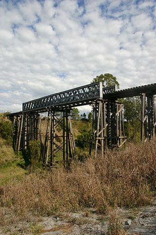
Woolooga Rail Bridge is a heritage-listed railway bridge at Wide Bay Creek on the Theebine - Kilikivan railway line, Woolooga, Gympie Region, Queensland, Australia. It was built in 1884 by Owen McDermott & Co. It was added to the Queensland Heritage Register on 21 October 1992.

The Kilkivan to Kingaroy Rail Trail is an 88-kilometre (55 mi) recreation trail from Kilkivan to Kingaroy. The trail follows the old Kingaroy Branch railway and is open to walkers, cyclists and horse riders.

<span class="mw-page-title-main">Burdekin River Rail Bridge</span> Bridge in Queensland, Australia

Burdekin River Rail Bridge is a heritage-listed former railway bridge on the Great Northern railway over the Burdekin River at Dotswood, Charters Towers Region, Queensland, Australia. It was designed by Henry Charles Stanley and built from c. 1896 to 1899 by Swanson Brothers. It is also known as Macrossan Bridge. It was added to the Queensland Heritage Register on 21 October 1992.

<span class="mw-page-title-main">Munna Creek</span> Suburb of Fraser Coast Region, Queensland, Australia

Munna Creek is a locality split between the Fraser Coast Region and the Gympie Region, in Queensland, Australia. In the 2016 census, Munna Creek had a population of 23 people.

<span class="mw-page-title-main">Murray River railway bridge, Albury–Wodonga</span> Bridge in New South Wales, Australia

The Murray River railway bridge is a heritage-listed Australian railway bridge over the Murray River on the Main Southern line south of Albury in the City of Albury, New South Wales, and on the North Eastern line north of Wodonga in Victoria. The bridge was designed by John Whitton and built from 1883 to 1884 by J. S. Bennett, with iron work supplied by Westwood, Baillie, England. It is also known as the Rail Bridge over Murray River, Albury–Wodonga and the Albury Lattice Railway Bridge and Murray River Underbridge. The bridge is owned by RailCorp, and maintained by the Australian Rail Track Corporation as part of its lease of the line. It was added to the New South Wales State Heritage Register on 2 April 1999, and added to the Register of the National Estate on 18 April 1989.

<span class="mw-page-title-main">Macquarie River railway bridge, Dubbo</span> Bridge in New South Wales, Australia

The Dubbo rail bridge over Macquarie River – Wambuul is a heritage-listed railway bridge on the Main Western line across the Macquarie River, located west of the Dubbo central business district in New South Wales, Australia. It was designed by John Whitton as the Engineer-in-Chief for the New South Wales Government Railways. The bridge was built during 1884 by Benjamin Barnes, with ironwork by Cochrane & Co, Middlesborough, England. The railway bridge is also known as the Dubbo Lattice Railway Bridge. The property is owned by Transport Asset Holding Entity, an agency of the Government of New South Wales. The bridge was added to the New South Wales State Heritage Register on 2 April 1999 and was listed on the Register of the National Estate on 18 April 1989.

<span class="mw-page-title-main">Lachlan River railway bridge</span> Bridge in New South Wales, Australia

The Lachlan River railway bridge is a heritage-listed former railway bridge which carried the Blayney–Demondrille railway line over the Lachlan River at Cowra, Cowra Shire, New South Wales, Australia. It was designed by John Whitton in his capacity as Engineer-in-Chief for Railways. The bridge was built from 1886 to 1887 by contractors Fishburn & Co. It is also known as the Cowra Rail Bridge over Lachlan River and the Cowra Lattice Railway Bridge. The property is owned by Transport Asset Holding Entity, an agency of the Government of New South Wales. It was added to the New South Wales State Heritage Register on 2 April 1999.

<span class="mw-page-title-main">Burnett railway bridge</span> Railway bridge in Queensland, Australia

Burnett Railway Bridge is a heritage-listed railway bridge crossing the Burnett River in Bundaberg, Queensland, Australia. The bridge is located between Bundaberg Central and Bundaberg North to the west of Burnett Road Bridge.

References

  1. https://cloud.hemax.com/Place/LocationDetails/b1b971e5-2f67-483e-b0b5-2284976c8cde?Dickabram%20Bridge%20Park%20Rest%20Area
  2. "NOTES AND EVENTS". The Colac Herald . Vol. XV, no. 1522. Victoria, Australia. 26 August 1884. p. 2. Retrieved 29 October 2022 via National Library of Australia.
  3. 1 2 3 4 5 6 7 8 9 10 11 "Dickabram Bridge (entry 600836)". Queensland Heritage Register . Queensland Heritage Council. Retrieved 1 August 2014.
  4. 1 2 "Work has begun on restoring Dickabram Bridge". Gympie Times. 26 December 2008. Archived from the original on 6 July 2011. Retrieved 3 March 2010.
  5. 1 2 "Dickabram Bridge reopens". Queensland Government. 24 April 2009. Archived from the original on 16 July 2011. Retrieved 3 March 2010.
  6. 1 2 "Centenary of the Dickabram Bridge | Monument Australia". monumentaustralia.org.au. Retrieved 29 October 2022.
  7. "COUNTRY MAILS". The Brisbane Courier . Vol. XLI, no. 8, 803. Queensland, Australia. 2 April 1886. p. 2. Retrieved 29 October 2022 via National Library of Australia.
  8. Walker, Carlie (19 May 2017). "Bridge with worker entombed to undergo renovation". The Courier Mail . Retrieved 29 October 2022.
  9. "LOCAL AND GENERAL NEWS". Gympie Times And Mary River Mining Gazette . Vol. III, no. 272. Queensland, Australia. 6 July 1870. p. 3. Retrieved 5 November 2022 via National Library of Australia.
  10. "Dickabram Bridge". Fraser Coast Online. 9 February 2009. Archived from the original on 21 February 2011. Retrieved 3 March 2010.
  11. "Dickabram Bridge rehabilitation works project flyer". Department of Transport and Main Roads. Queensland Government. May 2017.
  12. "Rehabilitation works on heritage-listed Dickabram Bridge Project update". Department of Transport and Main Roads. Queensland Government. January 2019.
  13. Kilkivan to Kingaroy Rail Trail Brochure v4. "Kilkivan to Kingaroy Rail Trail". Gympie Regional Council . Retrieved 29 October 2022.{{cite web}}: CS1 maint: numeric names: authors list (link)

Attribution

CC-BY-icon-80x15.png This Wikipedia article incorporates text from "The Queensland heritage register" published by the State of Queensland under CC-BY 3.0 AU licence (accessed on 7 July 2014, archived on 8 October 2014). The geo-coordinates were computed from the "Queensland heritage register boundaries" published by the State of Queensland under CC-BY 3.0 AU licence (accessed on 5 September 2014, archived on 15 October 2014).