Adelaide railway station is the central terminus of the Adelaide Metro railway system. All lines approach the station from the west, and it is a terminal station with no through lines, with most of the traffic on the metropolitan network either departing or terminating here. It has nine below-ground platforms, all using broad gauge track. The station is located on the north side of North Terrace, west of Parliament House.

Port Adelaide station, also known as Commercial Road, is a railway station located on the Outer Harbor line. Situated in the north-western Adelaide suburb of Alberton, it is 11.7 kilometres from Adelaide station.

The Adelaide rail network is a metropolitan suburban rail system serving the city of Adelaide, South Australia, Australia. It consists of 89 railway stations across 7 lines, which served a patronage of 15.6 million people over the year 2018-19. Keolis Downer under contract from the Government of South Australia operates the Adelaide suburban rail system. The operations are set to be handed back to the hands of the public by January 2025.

The Port River is part of a tidal estuary located north of the Adelaide city centre in the Australian state of South Australia. It has been used as a shipping channel since the beginning of European settlement of South Australia in 1836, when Colonel Light selected the site to use as a port. Before colonisation, the Port River region and the estuary area were known as Yerta Bulti by the Kaurna people, and used extensively as a source of food and plant materials to fashion artefacts used in daily life.

Osborne is a suburb in the Australian state of South Australia located on the Lefevre Peninsula in the west of Adelaide about 21 kilometres north-west of the Adelaide city centre.

Rail transport in the Australian state of South Australia is provided by a number of railway operators who operate over the government-owned railway lines. The network consists of 1435 mm standard gauge links to other states, the 1600 mm broad gauge suburban railways in Adelaide, a freight-only branch from Dry Creek to Port Adelaide and Pelican Point, a narrow-gauge gypsum haulage line on the Eyre Peninsula, and both copper–gold concentrate and coal on the standard-gauge line in the Adelaide–Darwin rail corridor north of Tarcoola.

Port Adelaide is a port-side region of Adelaide, approximately 14 kilometres (8.7 mi) northwest of the Adelaide CBD. It is also the namesake of the City of Port Adelaide Enfield council, a suburb, a federal and state electoral division and is the main port for the city of Adelaide. Port Adelaide played an important role in the formative decades of Adelaide and South Australia, with the port being early Adelaide's main supply and information link to the rest of the world. Its Kaurna name, although not officially adopted as a dual name, is Yertabulti.

The 3000 class and 3100 class are a class of diesel railcars that operate on the Adelaide rail network. Built by Comeng and Clyde Engineering between 1987 and 1996, they entered service under the State Transport Authority before later being operated by TransAdelaide and Adelaide Metro. Trains are typically coupled as multiple units, though the 3000 class are also able to run as single units when needed. In total, 70 railcars were built and are expected to be retired between 2030 and 2032.

Mary Helen MacKillop RSJ was an Australian religious sister of Scottish descent. She was born in Melbourne but is best known for her activities in South Australia. Together with Fr Julian Tenison-Woods, she founded the Sisters of St Joseph of the Sacred Heart, a congregation of religious sisters that established a number of schools and welfare institutions throughout Australia and New Zealand, with an emphasis on education for the rural poor.

Alberton railway station is the junction station for the Outer Harbor and Port Dock lines. Situated in the north-western Adelaide suburb of Alberton, it is 10.2 kilometres from Adelaide station. The station is listed on the South Australian Heritage Register.

Port Dock railway station is the terminus of the Port Dock line, located on Baker Street, Port Adelaide. The first station was located in the commercial centre at the corner of St Vincent Street and Lipson Street and served as the original terminus of the railway between Adelaide and Port Adelaide, which opened in 1856.

Ethelton station is located on the Outer Harbor line. Situated in the north-western Adelaide suburb of Ethelton, it is 13.1 kilometres from Adelaide station. The station is currently closed for reconstruction.

The Dry Creek–Port Adelaide railway line is an eight-kilometre east–west freight railway line running through Adelaide's north-western suburbs. The line is managed by the Australian Rail Track Corporation (ARTC) and is an important link between Port Adelaide, Pelican Point and the main interstate rail routes which link Adelaide with Melbourne, Perth, Darwin and Sydney. Prior to 1988, a limited local passenger service operated, stopping at five intermediate stations along the line. Since May 1988, the line has been freight-only.

The Gawler line, also known as the Gawler Central line, is a suburban commuter railway line in the city of Adelaide, South Australia. The Gawler Line is the most frequent and heavily patronised line in the Adelaide rail network.

Birkenhead is a north-western suburb of Adelaide 14 km from the CBD, on the Lefevre Peninsula, in South Australia, and lies within the City of Port Adelaide Enfield. It is adjacent to Peterhead, Exeter and Glanville. It is bounded to the south by the Gawler Reach of the Port River, to the north by Hargrave Street and in the west and east by the Outer Harbor railway line and the Port River respectively.
Port River Expressway is a 5.7-kilometre (3.5 mi) freeway-grade road. The expressway links Port Adelaide and the Lefevre Peninsula across the north-western suburbs of Adelaide to major interstate routes via North-South Motorway.

The Northfield railway line was a railway in northern Adelaide running Dry Creek and Northfield. The line branched east from the Gawler railway line just north of Dry Creek station. In earlier years, it saw mixed freight including livestock in and meat out of the Gepps Cross abattoirs and sale yards. In its later years, it was operated as part of the metropolitan passenger rail network and served three stations: Cavan, Pooraka, and Northfield.

Gillman is a predominantly industrial north-western suburb of Adelaide, in the City of Port Adelaide Enfield. It is located within the federal Division of Hindmarsh and the state electoral district of Port Adelaide.

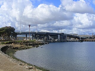
The Tom 'Diver' Derrick Bridge, commonly referred to as the 'Diver' Derrick Bridge, is an opening single-leaf bascule road bridge over the Port River, Port Adelaide, in South Australia. It opened on 1 August 2008. It is located between Docks 1 and 2 at Port Adelaide and links to Francis Street to the east and Victoria Road to the west.

The North–South Motorway is a partially complete motorway traversing the inner western suburbs of Adelaide, from Waterloo Corner in the north to Bedford Park in the south. Progressively constructed in stages since 2010, once complete it will replace the adjacent South Road as Adelaide's main north–south roadway. It will form the central section of the North–South Corridor, being flanked north and south by the Northern Expressway and Southern Expressway, respectively. It is designated part of route M2.


