Cremorne is an inner-city suburb in Melbourne, Victoria, Australia, 3 km (1.9 mi) south-east of the Melbourne central business district, located within the City of Yarra local government area. Cremorne recorded a population of 2,158 at the 2021 census.

East Richmond railway station is located on the Lilydale, Belgrave, Alamein and Glen Waverley lines in Victoria, Australia. It serves the inner eastern Melbourne suburb of Cremorne, and it opened on 24 September 1860 as Church Street. It was renamed East Richmond on 1 January 1867.
Cremorne railway station was an inner suburban station in Melbourne, Australia. It was on the Melbourne and Suburban Railway Company’s line from Princes Bridge station to Windsor station, and was located just north of Balmain Street on the Melbourne side of the Yarra River bridge, in a part of the suburb of Richmond which is now known as Cremorne.

South Yarra railway station is a commuter railway station and the junction point for the Cranbourne, Frankston, Pakenham and Sandringham lines, serving the south Melbourne suburb of South Yarra, Victoria, Australia. South Yarra is a premium status ground structure station featuring six platforms, with two island platforms and two side platforms connected by a ramp accessible overground concourse. The station opened on 22 December 1860 as Gardiners Creek Road before being renamed South Yarra on 1 January 1867.
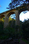
The Outer Circle Railway was opened in stages in 1890 and 1891, as a steam-era suburban railway line, in Melbourne, Australia. It traversed much of the modern City of Boroondara, including the suburbs of Kew East, Camberwell, Burwood, Ashburton, and Malvern East. At its longest, it ran from Fairfield station, on what is today the Hurstbridge line, to Oakleigh station, on the current Gippsland line.

The Sandringham line is a commuter railway line in the city of Melbourne, Victoria, Australia. Operated by Metro Trains Melbourne, it is the city's fourth shortest metropolitan railway line at 17.9 kilometres (11.1 mi). The line runs from Flinders Street station in central Melbourne to Sandringham station in the south-east, serving 14 stations via South Yarra, Balaclava, Elsternwick, and Brighton. The line operates from approximately 5am to 12am, daily, with 24 hour service available on Friday and Saturday nights. Services run every 7–8 minutes during peak hour, with services running every 15 minutes during the inter-peak period on weekdays, and every 20 minutes at night and during the day on weekends. Additionally, services run every 60 minutes overnight on Friday and Saturday nights as part of the Night Network.

Flinders Street is a street in Melbourne, Victoria, Australia. Running roughly parallel to the Yarra River, Flinders Street forms the southern edge of the Hoddle Grid. It is exactly 1 mi (1.6 km) in length and one and a half chains in width.

The Sandridge Bridge is a historic bridge, which originally carried railway lines over the Yarra River in Melbourne, Victoria, Australia. It runs diagonally to the river and is 178.4 metres (585 ft) long. In 2006, it was redeveloped as a pedestrian and cycle path, featuring public art. It is the third bridge on the site and is listed on the Victorian Heritage Register.

Yarra Park is part of the Melbourne Sports and Entertainment Precinct, the premier sporting precinct of Victoria, Australia. Located in Yarra Park is the Melbourne Cricket Ground (MCG) and numerous sporting fields and ovals, including the associated sporting complexes of Melbourne and Olympic Parks. The park and sporting facilities are located in the inner-suburb of East Melbourne. In the late 1850s, many of the earliest games of Australian rules football were played at Yarra Park, which was known at the time as the Richmond Paddock.

Victoria Street is one of the major thoroughfares of inner Melbourne, running east–west for over six kilometres between Munster Terrace in North Melbourne and the Yarra River. The road is known as Victoria Parade for over one-and-a-half kilometres of its length, distinguishable with a wide reservation and tramway down the middle.

The Walhalla railway line was a 2 ft 6 in narrow gauge railway located in Gippsland, Victoria, Australia. The line ran from Moe to the former gold-mining town and popular tourist destination of Walhalla. Construction began in 1904. The line closed in sections from 1944 to 1954.

Cremorne Gardens was a pleasure garden established in 1853 on the banks of the Yarra River at Richmond in Melbourne, Australia. The gardens were established by James Ellis who had earlier managed and leased similar gardens of the same name on the banks of the River Thames at Chelsea in London. He had been declared bankrupt and emigrated to Australia to take advantage of the business opportunities made possible by the Victorian gold rush and its accompanying population explosion. His first venture in the entertainment world in Melbourne was Astley's Amphitheatre, but his experiences in catering in London inclined him to a profit making business with a wider basis. Because of previous experience he had established contacts in the theatrical world of London. He took advantage of them to create a venue with viable entertainments to divert the population of the rapidly expanding capital of the new Australian state where entertainment was demanded by a predominantly male society.

Swan Street is a major street running through the Melbourne suburbs of Richmond, Cremorne and Burnley. The street was named after the White Swan Hotel, built in 1852 on the corner of Swan and Church Streets.

The Hawthorn Bridge crosses the Yarra River, five kilometres (3.1 mi) east of Melbourne, Victoria, Australia, connecting Bridge Road and Burwood Road. It is the oldest extant bridge over the Yarra River and is one of the oldest metal bridges in Australia. It was constructed in the early wave of major new infrastructure funded by the Victorian gold rush. Designed by Francis Bell, it is a substantial riveted, wrought iron, lattice truss structure, with bluestone abutments and piers.
The Ashworth Improvement Plan was a report that recommended a number of improvements to be made to the electrified suburban railways of inner city Melbourne, Australia. It was produced in 1940 by a committee headed by John Marmaduke Ashworth, the Victorian Railways Chief Engineer for Way and Works. In order to meet projected future needs, the report recommended duplication of lines, terminal improvements and underground railway connections.

Jolimont Yard was an array of railway lines and carriage sidings on the edge of the central business district of Melbourne, Australia. Located between Flinders Street station, Richmond Junction, the Yarra River and Flinders Street they were often criticised for cutting off the city from the river, being the site of many redevelopment proposals. The Princes Gate Towers were built over part of the yard in the 1960s, which themselves were replaced by Federation Square in the 2000s. The rail sidings themselves were progressively removed from the 1980s to the 1990s with only running lines today, but the area continues to be referred to as the 'Jolimont railyards' by Melburnians.

The Hawthorn Railway Bridge is a steel truss bridge that crosses the Yarra River 5 kilometres (3.1 mi) east of Melbourne between Burnley and Hawthorn stations on the Alamein, Belgrave and Lilydale railway lines. It was built for the Melbourne and Suburban Railway Company and is the oldest extant railway bridge over the Yarra River.
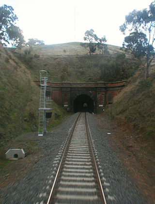
The Australian state of Victoria has only ever had about 10 tunnels on its railway network, with some others on private narrow gauge tramways. This is due to the relatively easy terrain through which most of the lines were built.
Pic Nic railway station, alternatively Pic-Nic, Pic-nic or Picnic, was a railway station in Melbourne, Australia. It was located on the Hawthorn line, on the Melbourne side of the Hawthorn Railway Bridge, between Church Street and Hawthorn stations and served the adjacent Burnley Park.

Collingwood was an electoral district of the Legislative Assembly in the Australian state of Victoria from 1856 to 1958. It centred on the Melbourne suburb of Collingwood, Victoria.