Darebin Creek Trail

Last updated

Darebin Creek Trail
Darebin Parklands March 2014.jpg
Darebin Parklands on the Lower Darebin part of the trail
LengthAbout 25 km
Location Melbourne, Victoria, Australia
DifficultyMedium
Hazards Gaps in the trail; Swooping magpies during breeding season
HillsSome uphill work along intersecting Western Ring Road trail (traveling North-East)
Train(s) Epping, Darebin stations
Tram(s) Route 86 tram

The Darebin Creek Trail is a shared use path for cyclists and pedestrians which follows Darebin Creek in the inner and outer northern suburbs of Melbourne, Victoria, Australia. [1] [2]

Contents

The path consists of an 8 km section north of the Western Ring Road and a 17 km section south of the Western Ring Road. The two sections are separated by a 0.85 km section of path along the Western Ring Road Trail.

Bicycle Victoria announced on 7 August 2009 on its web site that the Victorian Civil and Administrative Tribunal (VCAT) had approved the issuing of permits for the Lower Darebin Trail and associated bridge over the Yarra. Work on the Lower Darebin trail started late in 2010, and is expected to be completed in 2015.

Following the path

The northern section starts on the very edge of Melbourne surburbia next to open countryside. Travelling south through remnant vegetation and 2.2 km later, one arrives at Hendersons Rd. Epping station is 500m to the west along Hendersons Rd and the station is soon followed by Epping Plaza.

The path arrives at Childs Road, 1.3 km further along, having crossed a small footbridge earlier. Cross the Childs Road bridge to the east. The Hendersons Road Drain Trail is on the left (north) and the Darebin Creek Trail continues on the right (south), on the other side of Childs Road.

900m later the path forks to the left and right. Take the path towards the footbridge but do not cross it – continue straight ahead. After 2 km, McKimmies Road is approached. The path does not proceed under the road. Cross McKimmies Road and continue on for 1.6 km through Thomastown East Reserve. A small wetland nearby harbours the growling grass frog.

The path intersects with the Western Ring Road Trail. Travel 850m east along the Western Ring Road Trail to where the Darebin Creek Trail continues to the south on its west bank, crossing under the Western Ring Road. The creek name is signed for road users only but is clearly visible for trail users.

Leaving the Western Ring Road Trail the southern section starts by descending to the creek and tracking along the west bank of the creek. After crossing McCleans Road, the path splits in two, as it enters a Norris Bank Reserve. Either path can be taken as they rejoin at the far end of the reserve at Settlement Road.

On the south side of Settlement Road the path continues on the west side of the creek for 2.6 km until it reaches the eastern end of Rathcown Rd, by a paddock full of shaggy sheep where there is a new bridge crossing. (An on-road shortcut is to continue west along Rathcown Rd for 600 metres to a path on the left that re-connects to the Darebin Creek trail). The trail crosses to the eastern side where the path continues to a T-intersection where the path to the right follows the creek, left connects to Bundoora Park via Waters Way. At Chenies Street, Dunne Street and Plenty Rd, change sides of the creek. An unsigned path looms up on the left, that leads to the Bundoora campus of La Trobe University and is surveyed by a lone park bench.

800m later cross the footbridge to the east bank of the creek. The trail continues south past another footbridge on the right (west) that leads to Northland Shopping Centre. Do not cross the bridge, just continue onwards.

One km later the bitumen trail meets a crossing with a concrete trail. Turn right (west) onto the concrete trail and head downhill. Going straight ahead on the bitumen trail leads to the Austin Hospital helipad (Heidelberg Repatriation Hospital) near Bell Street.

Three km later the trail meets the north end of Ford Grove. Continue to the south end of Ford Grove where the trail continues. After another 500m the trail forks at a wooden boardwalk section: To the left (east) it crosses a footbridge. Take the right path and continue straight ahead towards Smith Street. The trail passes under the large and high steel bridge that carries the Hurstbridge railway line, and then under the bluestone and concrete Darebin Creek Bridge (Heidelberg Road), before finishing at Sparks Reserve.

The pedestrian and cycling bridge spanning the Yarra River, connecting the Darebin Creek Trail to the Main Yarra Trail, was opened on 25 March 2018. Community advocacy groups worked over a twenty-year period to achieve this impressive outcome.

Epping to South Morang rail extension

The extension of the rail line from Epping to South Morang [3] intersects the Darebin Creek Trail in the vicinity of Sunrise Crt and Maywood Drv, the Hendersons Road Drain Trail near Maywood Drv and the route to the City of Whittlesea's Mill Park Leisure Centre in Morang Drv.

Connections

Dead end in the north at Porsche Crt. Intersects the Hendersons Road Drain Trail in Mill Park at Childs Rd and the Western Ring Road Trail in Bundoora.

Connects to the Main Yarra Trail in the south

North end at 37°38′09″S145°02′06″E / 37.635830°S 145.034885°E / -37.635830; 145.034885 . South end at 37°47′24″S145°02′34″E / 37.790095°S 145.042660°E / -37.790095; 145.042660 .

Related Research Articles

<span class="mw-page-title-main">Reservoir, Victoria</span> Suburb of Melbourne, Victoria, Australia

Reservoir is a suburb in Melbourne, Victoria, Australia, 12 km (7.5 mi) north of Melbourne's Central Business District, located within the City of Darebin local government area. Reservoir recorded a population of 51,096 at the 2021 census.

<span class="mw-page-title-main">Moonee Ponds Creek Trail</span>

The Moonee Ponds Creek Trail is a shared use path for cyclists and pedestrians, which follows the Moonee Ponds Creek through the northern suburbs of Melbourne, Victoria, Australia.

<span class="mw-page-title-main">Maribyrnong River Trail</span>

The Maribyrnong River Trail is a shared use path for cyclists and pedestrians, which follows the Maribyrnong River through the north western suburbs of Melbourne, Victoria, Australia.

<span class="mw-page-title-main">Diamond Creek Trail</span> Path that follows the creek in Melbourne, Victoria, Australia

The Diamond Creek Trail is a shared use path for cyclists and pedestrians, which follows Diamond Creek through the north eastern outer suburbs of Melbourne, Victoria, Australia.

<span class="mw-page-title-main">Merri Creek Trail</span>

The Merri Creek Trail is a shared use path for cyclists and pedestrians that follows the Merri Creek through the northern suburbs of Melbourne, Victoria, Australia.

<span class="mw-page-title-main">Gardiners Creek Trail</span>

The Gardiners Creek Trail is a shared use path for cyclists and pedestrians, which follows Gardiners Creek through the eastern suburbs of Melbourne, Victoria, Australia.

<span class="mw-page-title-main">Darebin Creek</span> River in Victoria, Australia

Darebin Creek is a creek that runs through the northern suburbs of Melbourne, Victoria, Australia. It is the main watercourse of the Darebin Valley and a major tributary of the Yarra River. For tens of thousands of years it was used as a food and tool source sustainably by the Wurundjeri people, Indigenous Australians of the Kulin nation alliance, who spoke variations of the Woiwurrung language group.

<span class="mw-page-title-main">Outer Circle Trail</span>

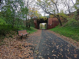
The Outer Circle Trail, also known as the Anniversary Trail, is a shared use path for cyclists and pedestrians, which partly follows the Alamein Line through the inner eastern suburbs of Melbourne, Victoria, Australia.

<span class="mw-page-title-main">Ringwood to Belgrave Rail Trail</span> Rail trail in Victoria, Australia

The Ringwood - Belgrave Rail Trail is a shared use path for cyclists and pedestrians, which follows the Belgrave railway line from the Mullum Mullum Creek Trail in Ringwood to Belgrave railway station in Belgrave, in the outer eastern suburbs of Melbourne, Victoria, Australia.

<span class="mw-page-title-main">Broadmeadows Valley Trail</span>

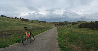
The Broadmeadows Valley Trail is a shared use path for cyclists and pedestrians in the outer northern suburbs of Melbourne, Victoria, Australia.

The Ferndale Park Trail is a shared use path for cyclists and pedestrians in the suburb of Glen Iris, an inner eastern suburb of Melbourne, Victoria.

<span class="mw-page-title-main">Kororoit Creek Trail</span> Cycling and pedestrian trail in Melbourne, Australia

The Kororoit Creek Trail is a shared use path for cyclists and pedestrians, which follows the Kororoit Creek in the inner western suburbs of Melbourne, Victoria, Australia.

<span class="mw-page-title-main">Mullum Mullum Creek Trail</span>

The Mullum Mullum Creek Trail is a shared use path for cyclists and pedestrians, which follows Mullum Mullum Creek in the outer eastern suburbs in Melbourne, Victoria, Australia.

The Plenty River Trail is a shared use path for cyclists and pedestrians, which follows the Plenty River through the suburbs of Greensborough and Lower Plenty in Melbourne, Victoria, Australia.

The Ruffey Creek Trail is a shared use path for cyclists and pedestrians, which follows Ruffey Creek in the inner eastern suburbs of Templestowe and Doncaster in Melbourne, Victoria, Australia.

<span class="mw-page-title-main">Northern Pipe Trail</span>

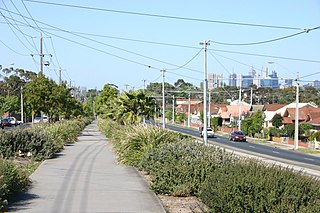
The Northern Pipe Trail, is a shared-use path for cyclists and pedestrians that follows Cheddar and St Georges Roads in the northern suburbs of Reservoir, Preston and Thornbury in Melbourne, Victoria, Australia.

The Tarralla Creek Trail is a shared use path for cyclists and pedestrians, which follows Tarralla Creek, in the outer eastern suburb of Croydon in Melbourne, Victoria, Australia. It is part of the Carrum to Warburton trail and Bayswater to Lilydale link.

<span class="mw-page-title-main">M80 Trail</span>

The M80 Trail is a shared-use path for cyclists and pedestrians that bridges the northern suburbs and follows the Western Ring Road/Metropolitan Ring Road (M80) freeway in Melbourne, Australia.

<span class="mw-page-title-main">Main Yarra Trail</span>

The Main Yarra Trail, also known as the Yarra Trail is a shared-use path for cyclists and pedestrians, which follows the Yarra River through the northeastern suburbs of Melbourne, Victoria, Australia.

<span class="mw-page-title-main">Bike paths in Melbourne</span> Cycling routes and cycling lanes in Melbourne, Australia

Bike paths around Melbourne have been developed over many decades. Many off-road trails follow current or former watercourses and traverse long distances, so that responsibility for planning and maintenance is split between various State Government authorities and local councils. With the increased recognition from all levels of government of the benefits of cycling, Melbourne today has a network of shared bicycle trails which have developed over time along its river and creek systems and alongside freeways and railways.

References

  1. Melbourne and Geelong's shared paths in Google Maps
  2. "Melbourne and Geelong's shared paths in Google Earth". Archived from the original on 12 October 2016. Retrieved 13 June 2007.
  3. South Morang rail extension