
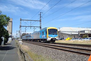
Reservoir is a suburb in Melbourne, Victoria, Australia, 12 km (7.5 mi) north of Melbourne's Central Business District, located within the City of Darebin local government area. Reservoir recorded a population of 51,096 at the 2021 census.

Thornbury is an inner-city suburb in Melbourne, Victoria, Australia, 7 km (4.3 mi) north-east of Melbourne's Central Business District, located within the City of Darebin local government area. Thornbury recorded a population of 19,005 at the 2021 census.
The Upfield Shared Path is a shared use path for cyclists and pedestrians, which follows Upfield railway line through the inner northern suburbs of Melbourne, Victoria, Australia.

Coburg North is a suburb in Melbourne, Victoria, Australia, 9 km (5.6 mi) north of Melbourne's Central Business District, located within the Cities of Darebin and Merri-bek local government areas. Coburg North recorded a population of 8,327 at the 2021 census.

Westgarth is a neighbourhood within the suburb of Northcote, about 4 or 5 km north-east of Melbourne's central business district in Victoria, Australia. It is in the local government area of the City of Darebin. The neighbourhood has a commercial centre, distinct from the main commercial centre of Northcote, located near Westgarth railway station, just north of Clifton Hill. While Westgarth does not have any official borders, it is generally considered to extend from Merri Creek in the west to the boundary of Fairfield in the east.

The Merri Creek Trail is a shared use path for cyclists and pedestrians that follows the Merri Creek through the northern suburbs of Melbourne, Australia.

The Gardiners Creek Trail is a shared use path for cyclists and pedestrians, which follows Gardiners Creek through the eastern suburbs of Melbourne, Victoria, Australia.

The Scotchmans Creek Trail is a shared use path for cyclists and pedestrians, which follows Scotchmans Creek through the eastern suburbs of Melbourne, Victoria, Australia.

The Blind Creek Trail, in the outer eastern suburbs of Melbourne, in the Australian state of Victoria, is a shared-use path for cyclists and pedestrians, which follows the Blind Creek from the Dandenong Creek Trail in Wantirna South to the Ringwood - Belgrave Rail Trail in Boronia.

The Ringwood to Belgrave Rail Trail is a shared use path for cyclists and pedestrians that follows the Belgrave railway line from the Mullum Mullum Creek Trail in Ringwood to Belgrave railway station in Belgrave, in the outer eastern suburbs of Melbourne, Victoria, Australia.

The Bushy Creek Trail is a shared use path for cyclists and pedestrians in the inner eastern suburb of Box Hill North in Melbourne, Victoria, Australia.

The Darebin Creek Trail is a shared use path for cyclists and pedestrians which follows Darebin Creek in the inner and outer northern suburbs of Melbourne, Victoria, Australia.
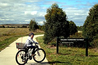
The Craigieburn Bypass Trail, is a shared use path for cyclists and pedestrians in the outer northern suburbs of Melbourne, Victoria, Australia. In 2008 it was given the local name of the Galada Tamboore Pathway - Wurundjeri for "creek waterhole" or "stream waterhole" - as it goes past the Craigieburn, Cooper street and Galada Tamboore grasslands which are all nationally significant for their plains grassland and riparian habitat for endangered and vulnerable native fauna and flora, including the critically endangered Golden Sun Moth.
The Greengully Trail is a shared use path for cyclists and pedestrians in the inner eastern suburb of Templestowe in Melbourne, Victoria, Australia.
The Hallam Bypass Trail is a shared use path for cyclists and pedestrians running along the Hallam Bypass between Doveton and Berwick in the outer eastern suburbs of Melbourne, Victoria, Australia. The trail was completed in 2003.

The Kororoit Creek Trail is a shared use path for cyclists and pedestrians, which follows the Kororoit Creek in the inner western suburbs of Melbourne, Victoria, Australia.

The Mullum Mullum Creek Trail is a shared use path for cyclists and pedestrians, which follows Mullum Mullum Creek in the outer eastern suburbs in Melbourne, Victoria, Australia. The Mullum Mullum Creek Trail extends from the Eastlink Trail at Sherbrook Park to Highland Avenue in Croydon.
The Tarralla Creek Trail is a shared use path for cyclists and pedestrians, which follows Tarralla Creek, in the outer eastern suburb of Croydon in Melbourne, Victoria, Australia. It is part of the Carrum to Warburton trail and Bayswater to Lilydale link.

The M80 Trail is a shared-use path for cyclists and pedestrians that bridges the northern suburbs and follows the Western Ring Road/Metropolitan Ring Road (M80) freeway in Melbourne, Australia.

The Main Yarra Trail, also known as the Yarra Trail is a shared-use path for cyclists and pedestrians, which follows the Yarra River through the northeastern suburbs of Melbourne, Victoria, Australia.
