
The City of Moonee Valley is a local government area located within the metropolitan area of Melbourne, Victoria, Australia, on Wurundjeri Woi-wurrung Country. It comprises the inner north-western suburbs between 3 and 13 kilometres from the Melbourne city centre. In 2023, the City of Moonee Valley Estimated Resident Population was 126,486, with a population density of 2,935 persons per square km, based on the 2023 Census.

The Maribyrnong River is a perennial river of the Port Phillip catchment, located in the north–western suburbs of Melbourne, in the Australian state of Victoria.

Airport West is a suburb in Melbourne, Victoria, Australia, 12 km (7.5 mi) north-west of Melbourne's Central Business District, located within the City of Moonee Valley local government area. Airport West recorded a population of 8,173 at the 2021 census.

Essendon is an Inner suburb in Melbourne, Victoria, Australia, 8 km (5.0 mi) north-west of Melbourne's central business district, located within the City of Moonee Valley local government area. Essendon recorded a population of 21,240 at the 2021 census.

Niddrie is a suburb in Melbourne, Victoria, Australia, 11 km (6.8 mi) north-west of Melbourne's Central Business District, located within the City of Moonee Valley local government area. Niddrie recorded a population of 5,901 at the 2021 census.

The Moonee Ponds Creek Trail is a shared use path for cyclists and pedestrians, which follows the Moonee Ponds Creek through the northern suburbs of Melbourne, Victoria, Australia.

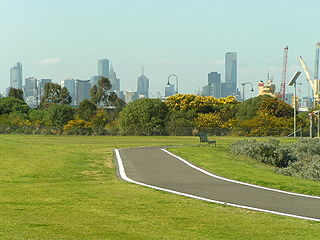
The Maribyrnong River Trail is a shared use path for cyclists and pedestrians, which follows the Maribyrnong River through the north western suburbs of Melbourne, Victoria, Australia.

The Merri Creek Trail is a shared use path for cyclists and pedestrians that follows the Merri Creek through the northern suburbs of Melbourne, Australia.

Avondale Heights is a suburb in Melbourne, Victoria, Australia, 11 km (6.8 mi) north-west of Melbourne's Central Business District, located within the City of Moonee Valley local government area. Avondale Heights recorded a population of 12,388 at the 2021 census.

The Division of Maribyrnong is an Australian electoral division in the state of Victoria. It is located in the inner north-western suburbs of Melbourne. Suburbs include Aberfeldie, Airport West, Avondale Heights, Essendon, Footscray, Gowanbrae, Keilor East, Maribyrnong, Moonee Ponds, Niddrie, West Footscray and Tullamarine. Due to redistributions, the division has been slowly moving west and changed with the introduction of the Division of Fraser in 2018. According to the 2011 census, Maribyrnong has the highest proportion of Catholics in any Commonwealth Electoral Division in Australia with 41.6% of the population.

Melbourne is Australia's second largest city and widely considered to be a garden city, with Victoria being nicknamed "the Garden State". Renowned as one of the most livable cities in the world, there is an abundance of parks, gardens and green belts close to the CBD with a variety of common and rare plant species amid landscaped vistas, pedestrian pathways, and tree-lined avenues, all managed by Parks Victoria.

Keilor East or East Keilor is a suburb in Melbourne, Victoria, Australia, 13 km (8.1 mi) north-west of Melbourne's Central Business District, located within the Cities of Brimbank and Moonee Valley local government areas. Keilor East recorded a population of 15,073 at the 2021 census.

Essendon Keilor College was founded in 1992 from the amalgamation of Queens Park Secondary College, Essendon High School, Niddrie High School and Keilor Heights Secondary College.

The electoral district of Niddrie is a metropolitan electorate approximately 8 kilometres (5 mi) northwest of Melbourne, Australia in Victoria's Legislative Assembly.
The Hobsons Bay Coastal Trail is a shared use path for cyclists and pedestrians, which follows the coast line of Hobsons Bay in the inner western suburbs in Melbourne, Victoria, Australia. The trail forms part of the western half of the Bayside Trail which encircles Port Phillip. It runs from the west side of the Westgate bridge, south and along the coast, finishing at the Skeleton Creek Trail in Sanctuary Lakes.

The M80 Trail is a shared-use path for cyclists and pedestrians that bridges the northern suburbs and follows the Western Ring Road/Metropolitan Ring Road (M80) freeway in Melbourne, Australia.
The City of Keilor was a local government area about 13 kilometres (8 mi) northwest of Melbourne, the state capital of Victoria, Australia. The city covered an area of 99.70 square kilometres (38.49 sq mi), and existed from 1863 until 1994.

The City of Sunshine was a local government area about 13 kilometres (8 mi) west of Melbourne, the state capital of Victoria, Australia. The city covered an area of 80.05 square kilometres (30.91 sq mi), and existed from 1860 until 1994.
The Keilor archaeological site was among the first places to demonstrate the antiquity of Aboriginal occupation of Australia when a cranium, unearthed in 1940, was found to be nearly 15,000 years old. Subsequent investigations of Pleistocene alluvial terraces revealed hearths about 31,000 years BP, making Keilor one of the earliest sites of human habitation in Australia. Remains of megafauna suggest a possible association with Aboriginal hunting.
The Green gully archaeological site is an Aboriginal archaeological site in Keilor, Victoria, Australia. The site was discovered during soil quarrying in the 1960s, when artefacts and a burial were uncovered in the alluvial terraces in the Maryibyrnong Valley.