The City of Kingston is a local government area in Victoria, Australia in the south-eastern suburbs of Melbourne, its northern boundary lying approximately 15 km from the Melbourne city centre along the north-eastern shorelines of Port Phillip. It covers an area of 91 km² and has an estimated population of 163,431 people.
Aspendale is a suburb in Melbourne, Victoria, Australia, 27 km south-east of Melbourne's Central Business District, located within the City of Kingston local government area. Aspendale recorded a population of 7,285 at the 2021 census.

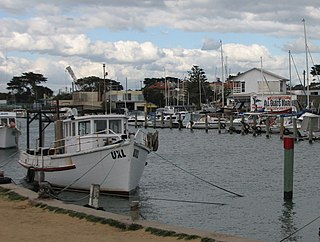
Carrum is a suburb in Melbourne, Victoria, Australia, 33 km (21 mi) south-east of Melbourne's Central Business District, located within the City of Kingston local government area. Carrum recorded a population of 4,239 at the 2021 census.

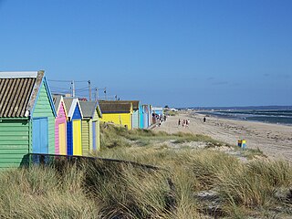
Edithvale is a beachside suburb in Melbourne, Victoria, Australia, 28 km south-east of Melbourne's Central Business District, located within the City of Kingston local government area. Edithvale recorded a population of 6,276 at the 2021 census.

Mentone is a suburb in Melbourne, Victoria, Australia, 21 km south-east of Melbourne's Central Business District, located within the City of Kingston local government area. Mentone recorded a population of 13,197 at the 2021 census.
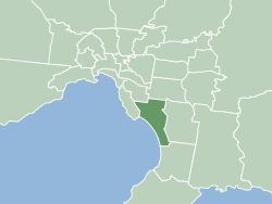
Mordialloc is a beachside suburb in Melbourne, Victoria, Australia, 24 km south-east of Melbourne's Central Business District, located within the City of Kingston local government area. Mordialloc recorded a population of 8,886 at the 2021 census.

Mordialloc railway station is a commuter railway station on the Frankston line, which is part of the Melbourne railway network. It serves the south-eastern suburb of Mordialloc, in Melbourne, Victoria, Australia. Mordialloc station is a ground level premium station, featuring two side platforms. It opened on 19 December 1881.

Edithvale railway station is a commuter railway station on the Frankston line, which is part of the Melbourne railway network. It serves the south-eastern suburb of the same name, in Melbourne, Victoria, Australia, and opened on 20 September 1919. The current station was opened in 2021.

Patterson Lakes is a suburb in Melbourne, Victoria, Australia, 35 km (22 mi) south-east of Melbourne's Central Business District, located within the City of Kingston local government area. Patterson Lakes recorded a population of 7,793 at the 2021 census.

The Mornington Peninsula Freeway is a freeway in Melbourne, Victoria, Australia, that provides a link from south-eastern suburban Melbourne to the Mornington Peninsula. Whilst the entire freeway from Dingley Village to Rosebud is declared by VicRoads as the Mornington Peninsula Freeway, the section between EastLink in Carrum Downs and Moorooduc Highway in Moorooduc is locally and commonly known as Peninsula Link. The entire freeway corridor bears the designation M11.

Seaford is a beachside suburb in Melbourne, Victoria, Australia, 36 km south-east of Melbourne's Central Business District, located within the City of Frankston local government area. Seaford recorded a population of 17,215 at the 2021 census.

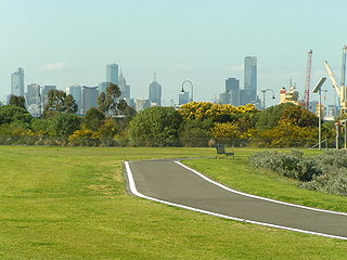
Parkdale is a suburb in Melbourne, Victoria, Australia, 23 km south-east of Melbourne's Central Business District, located within the City of Kingston local government area. Parkdale recorded a population of 12,308 at the 2021 census.

Beaumaris Bay is a short but wide bay within the eastern shore of Port Phillip Bay in southern Victoria, Australia. It commences at the cliffs of Rickett's Point in the southern end of the Melbourne suburb of Beaumaris, then recesses north briefly alongside Mentone Beach in Mentone before stretching south through a string of suburban beaches along Parkdale, Mordialloc, Aspendale, Edithvale, Bonbeach, Carrum and Seaford, and ends at a small headland near the Olivers Hill boat ramp at the junction between Frankston and Mount Eliza. The main tributary streams draining into the bay are Mordialloc Creek, Patterson River, Kananook Creek and Sweetwater Creek.
The Hobsons Bay Coastal Trail is a shared use path for cyclists and pedestrians, which follows the coast line of Hobsons Bay in the inner western suburbs in Melbourne, Victoria, Australia. The trail forms part of the western half of the Bayside Trail which encircles Port Phillip. It runs from the west side of the Westgate bridge, south and along the coast, finishing at the Skeleton Creek Trail in Sanctuary Lakes.

The Patterson River is a partly man-made urban river of the Port Phillip catchment in the Australian east coast state of Victoria, located in the outer southeastern suburbs of the Greater Melbourne region. Under the name "Patterson", it is the shortest river in Victoria at only 5 km (3.1 mi) in length, although its main stem tributary and de facto upper section, the Dandenong Creek, is over 53 km (33 mi) long.

The Main Yarra Trail, also known as the Yarra Trail is a shared-use path for cyclists and pedestrians, which follows the Yarra River through the northeastern suburbs of Melbourne, Victoria, Australia.

Port Phillip, sometimes referred to as Port Phillip Bay, is a large bay in southern Victoria, Australia, 1,930 km2 in area, with a coastline length of 264 km (164 mi). The bay is extremely shallow for its size, but mostly navigable. The deepest portion is only 24 m (80 ft), and half the region is shallower than 8 m. Its volume is around 25 km3. The city of Melbourne is located at its northern end, near the mouth of the Yarra River.

Port Phillip is in Victoria, Australia. It has many beaches, most of which are flat, shallow and long, with very small breaks making swimming quite safe. This attracts many tourists, mostly families, to the beaches of Port Phillip during the summer months and school holidays. Water sports such as body boarding and swimming are common, though waves are very rarely large enough for surfing. A number of lifesaving clubs operate along Port Phillip’s beaches.
The Edithvale–Seaford Wetlands is a collection of principally freshwater swamps and marshlands totalling 261 hectares in southeastern Melbourne, Australia, about 30 km (19 mi) southeast of Melbourne CBD. It is the largest natural wetland of its type in the Port Phillip and Western Port basins, and is all that remains of the historic Carrum Carrum Swamp, which once covered more than 4,000 hectares from present-day Mordialloc in the north to Frankston in the south.
The Longbeach Trail is a shared-use bicycle and pedestrian path running from Patterson River, Carrum, along the southwestern side of the Edithvale-Seaford Wetlands, to the Mordialloc Creek, Mordialloc. In Mordialloc, it connects to the Mordialloc Creek Trail and the Bay Trail and in the Carrum it connects to the Bay Trail and Dandenong Creek Trail.
