Craigieburn Bypass Trail

Last updated

Craigieburn Bypass Trail
Galada Tamboore cycle path start at Craigieburn.jpg
Sign at Craigieburn at the start of the trail
Length15.5km
Location Melbourne, Victoria, Australia
DifficultyEasy
Surface Wide concrete
HillsNothing serious
WaterNone
Train(s) Craigieburn station
Tram(s)None

The Craigieburn Bypass Trail (also known as the Galada Tamboore Pathway), is a shared use path for cyclists and pedestrians in the outer northern suburbs of Melbourne, Victoria, Australia. [1] [2] [3] In 2008 it was given the local name of the Galada Tamboore Pathway - Wurundjeri for "creek waterhole" or "stream waterhole" - as it goes past the Craigieburn, Cooper street and Galada Tamboore grasslands which are all nationally significant for their plains grassland and riparian habitat for endangered and vulnerable native fauna and flora, [4] [5] [6] including the critically endangered Golden Sun Moth.

Contents

While in Craigieburn consider a side trip to Mount Ridley or a return trip via the Broadmeadows Valley Trail.

An interactive map of the trail as well as others in the Melbourne area is available from the 'External Links' section in this article.

Following the path

The north end of the trail starts at the intersection of Grand Blvd and the Hume Highway. If starting from Craigieburn railway station, it would be more convenient to access the trail via Craigieburn Road.

The path has some interesting features including the Northern lights and the Barry Road (Whittlesea Gardens) footbridge - see the Craigieburn Bypass.

The trail finally makes a sharp turn to the east and meets up with the Western Ring Road Trail near a footbridge over the Western Ring Road. If going east on the Western Ring Road Trail just continue onwards. If heading west along the Western Ring Road Trail cross the footbridge to the southern side of the highway.

Whittlesea Gardens Footbridge

A rust red coloured footbridge at the Whittlesea Gardens in Lalor provides views of the Hume Freeway with the Melbourne CBD skyline on the horizon. The footbridge leads into an unsealed track through the Galada Tamboore grasslands and over Merri Creek. The track becomes sealed on the east side of the bridge to Merri Concourse and follows the Creek south along the west bank as far as Somerset Road, Campbellfield with sweeping views across the creek valley to the Galada Tamboore grasslands and the Hume Freeway on the horizon.

Connections

The electrified railway service to Craigieburn station was opened on 30 September 2007 together with a new station at Roxburgh Park at Somerton Road - Roxburgh Park railway station. The Craigieburn service was previously by Sprinter Railcars.

North end at 37°35′03″S144°56′27″E / 37.584216°S 144.940926°E / -37.584216; 144.940926 South end at 37°41′17″S144°59′38″E / 37.687985°S 144.993985°E / -37.687985; 144.993985 .

Related Research Articles

<span class="mw-page-title-main">Hume Highway</span> Major national highway in Australia

Hume Highway, inclusive of the sections now known as Hume Freeway and Hume Motorway, is one of Australia's major inter-city national highways, running for 840 kilometres (520 mi) between Melbourne in the southwest and Sydney in the northeast. Upgrading of the route from Sydney's outskirts to Melbourne's outskirts to dual carriageway was completed on 7 August 2013.

<span class="mw-page-title-main">Craigieburn, Victoria</span> Suburb of Melbourne, Victoria, Australia

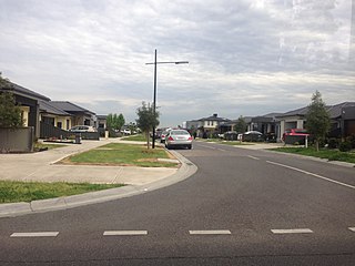
Craigieburn is a suburb in Melbourne, Victoria, Australia, 25 km (16 mi) north of Melbourne's Central Business District, located within the City of Hume local government area. Craigieburn recorded a population of 65,178 at the 2021 census.

<span class="mw-page-title-main">Merri Creek</span> River in Victoria, Australia

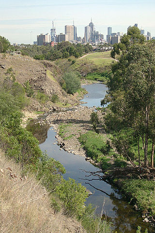
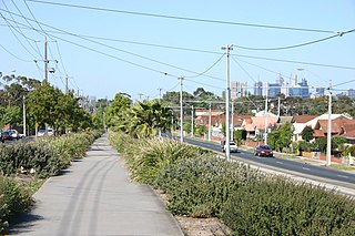
The Merri Creek is a waterway in southern parts of Victoria, Australia, which flows through the northern suburbs of Northcote. It begins near Wallan north of Melbourne and flows south for 70 km until it joins the Yarra River at Dights Falls. The area where the creek meets the river was traditionally the location for large gatherings of the Wurundjeri people and is suspected to have been the location for one of the earliest land treaties in Australia between Indigenous Australians and European settlers.

<span class="mw-page-title-main">Upfield Bike Path</span>

The Upfield Shared Path is a shared use path for cyclists and pedestrians, which follows Upfield railway line through the inner northern suburbs of Melbourne, Victoria, Australia.

<span class="mw-page-title-main">Moonee Ponds Creek Trail</span>

The Moonee Ponds Creek Trail is a shared use path for cyclists and pedestrians, which follows the Moonee Ponds Creek through the northern suburbs of Melbourne, Victoria, Australia.

<span class="mw-page-title-main">Maribyrnong River Trail</span>

The Maribyrnong River Trail is a shared use path for cyclists and pedestrians, which follows the Maribyrnong River through the north western suburbs of Melbourne, Victoria, Australia.

<span class="mw-page-title-main">Merri Creek Trail</span>

The Merri Creek Trail is a shared use path for cyclists and pedestrians that follows the Merri Creek through the northern suburbs of Melbourne, Victoria, Australia.

<span class="mw-page-title-main">Kalkallo, Victoria</span> Suburb of City of Hume, Victoria, Australia

Kalkallo is a suburb in Melbourne, Victoria, Australia, 31 km (19 mi) north of Melbourne's Central Business District, located within the City of Hume local government area. Kalkallo recorded a population of 5,548 at the 2021 census.

<span class="mw-page-title-main">Ringwood to Belgrave Rail Trail</span>

The Ringwood - Belgrave Rail Trail is a shared use path for cyclists and pedestrians, which follows the Belgrave railway line from the Mullum Mullum Creek Trail in Ringwood to Belgrave railway station in Belgrave, in the outer eastern suburbs of Melbourne, Victoria, Australia.

<span class="mw-page-title-main">Broadmeadows Valley Trail</span>

The Broadmeadows Valley Trail is a shared use path for cyclists and pedestrians in the outer northern suburbs of Melbourne, Victoria, Australia.

<span class="mw-page-title-main">Darebin Creek Trail</span>

The Darebin Creek Trail is a shared use path for cyclists and pedestrians which follows Darebin Creek in the inner and outer northern suburbs of Melbourne, Victoria, Australia.

The Hallam Bypass Trail is a shared use path for cyclists and pedestrians running along the Hallam Bypass between Doveton and Berwick in the outer eastern suburbs of Melbourne, Victoria, Australia. The trail was completed in 2003.

<span class="mw-page-title-main">Kororoit Creek Trail</span>

The Kororoit Creek Trail is a shared use path for cyclists and pedestrians, which follows the Kororoit Creek in the inner western suburbs of Melbourne, Victoria, Australia.

The Skeleton Creek Trail is a shared use path for cyclists and pedestrians, which follows Skeleton Creek as it passes through the outer south western suburbs of Point Cook and Altona Meadows in Melbourne, Victoria, Australia.

<span class="mw-page-title-main">Northern Pipe Trail</span>

The Northern Pipe Trail, is a shared-use path for cyclists and pedestrians that follows Cheddar and St Georges Roads in the northern suburbs of Reservoir, Preston and Thornbury in Melbourne, Victoria, Australia.

The Werribee River Trail is a shared use path for cyclists and pedestrians, which follows Werribee River in the outer western suburb of Werribee in Melbourne, Victoria, Australia.

<span class="mw-page-title-main">M80 Trail</span>

The M80 Trail is a shared-use path for cyclists and pedestrians that bridges the northern suburbs and follows the Western Ring Road/Metropolitan Ring Road (M80) freeway in Melbourne, Australia.

<span class="mw-page-title-main">Shire of Bulla</span> Local government area in Victoria, Australia

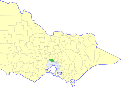
The Shire of Bulla was a local government area about 40 kilometres (25 mi) northwest of Melbourne, the state capital of Victoria, Australia. The shire covered an area of 422.17 square kilometres (163.0 sq mi), and existed from 1862 until 1994.

<span class="mw-page-title-main">Main Yarra Trail</span>

The Main Yarra Trail, also known as the Yarra Trail is a shared-use path for cyclists and pedestrians, which follows the Yarra River through the northeastern suburbs of Melbourne, Victoria, Australia.
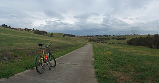
<span class="mw-page-title-main">Bike paths in Melbourne</span> Cycling routes and cycling lanes in Melbourne, Australia

Bike paths around Melbourne have been developed over many decades. Many off-road trails follow current or former watercourses and traverse long distances, so that responsibility for planning and maintenance is split between various State Government authorities and local councils. With the increased recognition from all levels of government of the benefits of cycling, Melbourne today has a network of shared bicycle trails which have developed over time along its river and creek systems and alongside freeways and railways.

References

  1. VicRoads - Bicycle Facilities Map Archived February 19, 2007, at the Wayback Machine
  2. Melbourne and Geelong's shared paths in Google Maps
  3. "Melbourne and Geelong's shared paths in Google Earth". Archived from the original on 12 October 2016. Retrieved 13 June 2007.
  4. Merri Creek Management Committee, Craigieburn Grasslands Accessed April 25, 2011
  5. Merri Creek Management Committee, Galada Tamboore Significance Accessed April 25, 2011
  6. Merri Creek Management Committee, Cooper Street Grasslands Significance Accessed April 25, 2011