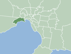
The City of Hobsons Bay is a local government area in Melbourne, Victoria, Australia. It comprises the south-western suburbs between 6 and 20 km from the Melbourne city centre.

The Maribyrnong River is a perennial river of the Port Phillip catchment, located in the north–western suburbs of Melbourne, in the Australian state of Victoria.

Newport is a suburb in Melbourne, Victoria, Australia, 10 km (6.2 mi) south-west of Melbourne's Central Business District, located within the City of Hobsons Bay local government area. Newport recorded a population of 13,658 at the 2021 census.

Yarraville is an inner-city suburb in Melbourne, Victoria, Australia, 6 km (3.7 mi) west of Melbourne's Central Business District, located within the City of Maribyrnong local government area. Yarraville recorded a population of 15,636 at the 2021 census.

The Moonee Ponds Creek Trail is a shared use path for cyclists and pedestrians, which follows the Moonee Ponds Creek through the northern suburbs of Melbourne, Victoria, Australia.

The Capital City Trail is a shared use path in Melbourne, Victoria, Australia, which circles the city centre and some inner eastern and northern suburbs. It is 29km in length, and mostly consists of sections of other trails, such as the Merri Creek Trail, Main Yarra Trail, Moonee Ponds Creek Trail and Inner Circle Rail Trail.

The Maribyrnong River Trail is a shared use path for cyclists and pedestrians, which follows the Maribyrnong River through the north western suburbs of Melbourne, Victoria, Australia.

The Merri Creek Trail is a shared use path for cyclists and pedestrians that follows the Merri Creek through the northern suburbs of Melbourne, Victoria, Australia.

The Federation Trail is a 23-kilometre-long (14 mi) shared use path for cyclists and pedestrians, which mainly follows the heritage-listed Main Outfall Sewer through the western suburbs of Melbourne, Victoria, Australia. There are three bridges spanning across major arterial roads, as well as button-activated traffic light crossings at most other major road-trail intersections.

The Kororoit Creek Trail is a shared use path for cyclists and pedestrians, which follows the Kororoit Creek in the inner western suburbs of Melbourne, Victoria, Australia.
The Laverton Creek Trail is a shared use path for cyclists and pedestrians, which follows Laverton Creek in the outer western suburbs of Laverton and Altona in Melbourne, Victoria, Australia.

The Sandridge Trail is a shared-use path for cyclists and pedestrians located in the inner southern suburb of Port Melbourne in Melbourne, Victoria, Australia.
The Skeleton Creek Trail is a shared use path for cyclists and pedestrians, which follows Skeleton Creek as it passes through the outer south western suburbs of Point Cook and Altona Meadows in Melbourne, Victoria, Australia.
The Taylors Creek Trail is a shared use path for cyclists and pedestrians, which follows Taylors Creek in the outer north-west suburb of Taylors Lakes in Melbourne, Victoria, Australia.
Melbourne West Province was an electorate of the Victorian Legislative Council from 1904 until 2006.

The Main Yarra Trail, also known as the Yarra Trail is a shared-use path for cyclists and pedestrians, which follows the Yarra River through the northeastern suburbs of Melbourne, Victoria, Australia.

Port Phillip, sometimes referred to as Port Phillip Bay, is a large bay in southern Victoria, Australia, 1,930 km2 in area, with a coastline length of 264 km (164 mi). The bay is extremely shallow for its size, but mostly navigable. The deepest portion is only 24 m (80 ft), and half the region is shallower than 8 m. Its volume is around 25 km3. The city of Melbourne is located at its northern end, near the mouth of the Yarra River.
South Yarra Province was an electorate of the Victorian Legislative Council from November 1882 until May 1904.
The Bay Trail is a shared use path for cyclists and pedestrians which follows the coastline of Port Phillip Bay through the south-eastern suburbs of Melbourne, Victoria, Australia.

The Westgate Punt is a passenger ferry service in Melbourne, Victoria, Australia. It operates on the Yarra River, connecting the suburbs of Spotswood and Port Melbourne with a journey of 0.5 kilometres (0.27 nmi). The ferry service is operated by Rob Horner, however subsidised and overseen by Public Transport Victoria. It is the only commuter ferry service operating within metropolitan Melbourne.

