
The Maribyrnong River is a perennial river of the Port Phillip catchment, located in the north–western suburbs of Melbourne, in the Australian state of Victoria.

Keilor is a suburb in Melbourne, Victoria, Australia, 16 km (9.9 mi) north-west of Melbourne's Central Business District, located within the Cities of Brimbank and Hume local government areas. Keilor recorded a population of 5,906 at the 2021 census.
Melton Highway links Melbourne's outer north-western suburbs of Melton and Taylors Lakes, connecting the Western Freeway and Calder Freeway to provide a more-direct route between Ballarat and Melbourne and Essendon airports; it has a Victorian route designation of C754.

Taylors Lakes is a suburb in Melbourne, Victoria, Australia, 20 km (12 mi) north-west of Melbourne's Central Business District, located within the City of Brimbank local government area. Taylors Lakes recorded a population of 16,910 at the 2021 census.
Keilor Downs is a suburb in Melbourne, Victoria, Australia, 18 km (11 mi) north-west of Melbourne's Central Business District, located within the City of Brimbank local government area. Keilor Downs recorded a population of 9,857 at the 2021 census.

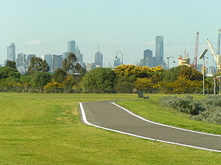
The Moonee Ponds Creek Trail is a shared use path for cyclists and pedestrians, which follows the Moonee Ponds Creek through the northern suburbs of Melbourne, Victoria, Australia.

The Capital City Trail is a shared use path in Melbourne, Victoria, Australia, which circles the city centre and some inner eastern and northern suburbs. It is 29km in length, and mostly consists of sections of other trails, such as the Merri Creek Trail, Main Yarra Trail, Moonee Ponds Creek Trail and Inner Circle Rail Trail.

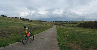
The Maribyrnong River Trail is a shared use path for cyclists and pedestrians, which follows the Maribyrnong River through the north western suburbs of Melbourne, Victoria, Australia.

The Merri Creek Trail is a shared use path for cyclists and pedestrians that follows the Merri Creek through the northern suburbs of Melbourne, Victoria, Australia.
Brimbank Park is a metropolitan regional park managed by Parks Victoria situated in the north-western Melbourne suburb of Keilor East, Victoria, Australia.

Keilor Park is a suburb in Melbourne, Victoria, Australia, 15 km (9.3 mi) north-west of Melbourne's Central Business District, located within the City of Brimbank local government area. Keilor Park recorded a population of 2,684 at the 2021 census.

Keilor East or East Keilor is a suburb in Melbourne, Victoria, Australia, 13 km (8.1 mi) north-west of Melbourne's Central Business District, located within the Cities of Brimbank and Moonee Valley local government areas. Keilor East recorded a population of 15,073 at the 2021 census.
The Broadmeadows Valley Trail is a shared use path for cyclists and pedestrians in the outer northern suburbs of Melbourne, Victoria, Australia.
The Hobsons Bay Coastal Trail is a shared use path for cyclists and pedestrians, which follows the coast line of Hobsons Bay in the inner western suburbs in Melbourne, Victoria, Australia. The trail forms part of the western half of the Bayside Trail which encircles Port Phillip. It runs from the west side of the Westgate bridge, south and along the coast, finishing at the Skeleton Creek Trail in Sanctuary Lakes.
The Laverton Creek Trail is a shared use path for cyclists and pedestrians, which follows Laverton Creek in the outer western suburbs of Laverton and Altona in Melbourne, Victoria, Australia.
The Ruffey Creek Trail is a shared use path for cyclists and pedestrians, which follows Ruffey Creek in the inner eastern suburbs of Templestowe and Doncaster in Melbourne, Victoria, Australia.
The Steele Creek Trail is a shared use path for cyclists and pedestrians, which follows Steele Creek in the Outer North Western suburbs of Keilor Park, Keilor East, Tullamarine, Airport West, Melbourne Airport, Avondale heights, Essendon West and Niddrie in Melbourne.

The M80 Trail is a shared-use path for cyclists and pedestrians that bridges the northern suburbs and follows the Western Ring Road/Metropolitan Ring Road (M80) freeway in Melbourne, Australia.
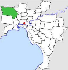
The City of Keilor was a local government area about 13 kilometres (8 mi) northwest of Melbourne, the state capital of Victoria, Australia. The city covered an area of 99.70 square kilometres (38.49 sq mi), and existed from 1863 until 1994.
The Green gully archaeological site is an Aboriginal archaeological site in Keilor, Victoria, Australia. The site was discovered during soil quarrying in the 1960s, when artefacts and a burial were uncovered in the alluvial terraces in the Maryibyrnong Valley.