Ashwood is a suburb in Melbourne, Victoria, Australia, 14 km south east of Melbourne's Central Business District, located within the City of Monash local government area. Ashwood recorded a population of 7,154 at the 2021 census.
Chadstone is a suburb in Melbourne, Victoria, Australia, 14 km (8.7 mi) south-east of Melbourne's Central Business District, located within the City of Monash local government area. Chadstone recorded a population of 9,552 at the 2021 census.

Glen Waverley is an eastern suburb in Melbourne, Victoria, Australia, 19 km (12 mi) south-east of Melbourne's Central Business District, located within the City of Monash local government area. Glen Waverley recorded a population of 42,642 at the 2021 census.

Mount Waverley is a suburb in Melbourne, Victoria, Australia, 16 km (9.9 mi) south-east of Melbourne's Central Business District, located within the City of Monash local government area. Mount Waverley recorded a population of 35,340 at the 2021 census.

East Malvern railway station is a commuter railway station on the Glen Waverley line, which is part of the Melbourne railway network. It serves the eastern suburb of Malvern East, in Melbourne, Victoria, Australia. East Malvern station is a ground level unstaffed station, featuring two side platforms. It opened on 3 February 1929, with the current station provided in 1975.

Syndal railway station is a commuter railway station on the Glen Waverley line, which is part of the Melbourne railway network. It serves the south-eastern suburb of Glen Waverley, in Melbourne, Victoria, Australia. Syndal station is a ground level unstaffed station, featuring an island platform with two faces, connected to Hunter Street and Coleman Parade via a pedestrian subway. It opened on 5 May 1930, with the current station provided in 1964.

The Gardiners Creek Trail is a shared use path for cyclists and pedestrians, which follows Gardiners Creek through the eastern suburbs of Melbourne, Victoria, Australia.

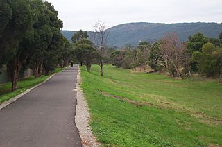
The Dandenong Creek Trail is a shared use path for cyclists and pedestrians, which follows Dandenong Creek through the outer eastern and south-eastern suburbs of Melbourne, Victoria, Australia.

Gardiners Creek, originally known as Kooyongkoot Creek, is an urban stream in the eastern suburbs of Melbourne, and part of the Yarra River catchment.
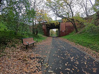
The Outer Circle Trail, also known as the Anniversary Trail, is a shared use path for cyclists and pedestrians, which partly follows the Alamein line through the inner eastern suburbs of Melbourne, Victoria, Australia.

The Scotchmans Creek Trail is a shared use path for cyclists and pedestrians, which follows Scotchmans Creek through the eastern suburbs of Melbourne, Victoria, Australia.

The Ringwood to Belgrave Rail Trail is a shared use path for cyclists and pedestrians that follows the Belgrave railway line from the Mullum Mullum Creek Trail in Ringwood to Belgrave railway station in Belgrave, in the outer eastern suburbs of Melbourne, Victoria, Australia.

The Bushy Creek Trail is a shared use path for cyclists and pedestrians in the inner eastern suburb of Box Hill North in Melbourne, Victoria, Australia.
The Ferny Creek Trail is a shared use path for cyclists and pedestrians, which follows Ferny and Corhanwarrabul Creeks through the suburbs of Knoxfield and Ferntree Gully in Melbourne, Victoria, Australia.
The Tarralla Creek Trail is a shared use path for cyclists and pedestrians, which follows Tarralla Creek, in the outer eastern suburb of Croydon in Melbourne, Victoria, Australia. It is part of the Carrum to Warburton trail and Bayswater to Lilydale link.
The Wurundjeri Walk Trail is a shared use path for cyclists and pedestrians in the inner eastern suburbs of Blackburn South and Forest Hill in Melbourne, Victoria, Australia.

The Syndal Heatherdale Pipe Reserve Trail is a shared use path for cyclists and pedestrians, which follows the Syndal to Heatherdale pipe reserve in the eastern suburbs of Melbourne, Victoria, Australia.
Warrigal Road is a major inner urban road in southeastern Melbourne, Australia. On weekdays, it is heavily trafficked as it runs through many major suburbs along its route, traversing some of Melbourne's eastern and south-eastern suburbs. These suburbs include Chadstone, Oakleigh, and Cheltenham. The Chadstone Shopping Centre can be accessed directly from Warrigal Road at its eastern entrance.

Bicycle paths around Melbourne are off-road routes for use by people riding bicycles and walking have been developed over many decades. These primarily follow current or former watercourses and major roads to traverse long distances and provide facilities for both transport and recreation.

The Djerring Trail is a shared use path that runs alongside the Cranbourne and Pakenham railway lines in south-eastern Melbourne, Australia. The route serves a total of 13 railway stations.

