State Route 14 is a north–south state highway in the U.S. state of California that connects Los Angeles to the northern Mojave Desert. The southern portion of the highway is signed as the Antelope Valley Freeway. The route connects Interstate 5 on the border of the city of Santa Clarita to the north and the Los Angeles neighborhoods of Granada Hills and Sylmar to the south, with U.S. Route 395 (US 395) near Inyokern. Legislatively, the route extends south of I-5 to SR 1 in the Pacific Palisades area of Los Angeles; however, the portion south of the junction with I-5 has not been constructed. The southern part of the constructed route is a busy commuter freeway serving and connecting the cities of Santa Clarita, Palmdale, and Lancaster to the rest of the Greater Los Angeles area. The northern portion, from Vincent to US 395, is legislatively named the Aerospace Highway, as the highway serves Edwards Air Force Base, once one of the primary landing strips for NASA's Space Shuttle, as well as the Naval Air Weapons Station China Lake that supports military aerospace research, development and testing. This section is rural, following the line between the hot Mojave desert and the forming Sierra Nevada mountain range. Most of SR 14 is loosely paralleled by a rail line originally built by the Southern Pacific Railroad, and was once the primary rail link between Los Angeles and Northern California. While no longer a primary rail line, the southern half of this line is now used for the Antelope Valley Line of the Metrolink commuter rail system.

A rail trail is a shared-use path on railway right of way. Rail trails are typically constructed after a railway has been abandoned and the track has been removed, but may also share the right of way with active railways, light rail, or streetcars, or with disused track. As shared-use paths, rail trails are primarily for non-motorized traffic including pedestrians, bicycles, horseback riders, skaters, and cross-country skiers, although snowmobiles and ATVs may be allowed. The characteristics of abandoned railways—gentle grades, well-engineered rights of way and structures, and passage through historical areas—lend themselves to rail trails and account for their popularity. Many rail trails are long-distance trails, while some shorter rail trails are known as greenways or linear parks.
Mirboo North is a town in Victoria, Australia, located 150 kilometres (93 mi) east of Melbourne, with a population of 1,697. It is in the South Gippsland Shire local government area.

The Strzelecki Ranges is a set of low mountain ridges located in the West Gippsland and South Gippsland regions of the Australian state of Victoria.

The Monon Trail is a rail trail located entirely within the state of Indiana. The Monon Railroad was a popular railroad line connecting the cities of Chicago and Indianapolis, with stops at major settlements along its route. After the decline of railroad travel and the sale of the company in 1987, the portion of the line between Indianapolis and Delphi, Indiana, was abandoned.

The Long Path is a 357-mile (575 km) long-distance hiking trail beginning in New York City, at the West 175th Street subway station near the George Washington Bridge and ending at Altamont, New York, in the Albany area. While not yet a continuous trail, relying on road walks in some areas, it nevertheless takes in many of the popular hiking attractions west of the Hudson River, such as the New Jersey Palisades, Harriman State Park, the Shawangunk Ridge and the Catskill Mountains. It offers hikers a diversity of environments to pass through, from suburbia and sea-level salt marshes along the Hudson to wilderness and boreal forest on Catskill summits 4,000 feet (1,220 m) in elevation.
Boolarra is a small township located in the Latrobe Valley, in central Gippsland, Victoria, Australia. At the 2016 Census, Boolarra had a population of 973 with 48% males and 52% females and an average age of 50. The Boolarra Folk Festival is held in the town every year in March and attracts music lovers from around Australia and the world. The town is also infamous for producing the Boolarra strain of carp which, after their release into the Murray River near Mildura, spread throughout Australia.
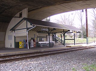
Cynwyd station is a SEPTA Regional Rail station in Bala Cynwyd, Pennsylvania. Located at Conshohocken State Road and Bala Avenue, it is the last station along the Cynwyd Line. The station includes a 41-space parking lot.

The Gippsland line is a railway line serving the Latrobe Valley and Gippsland regions of Victoria, Australia. It runs east from the state capital Melbourne through the cities of Moe, Morwell, Traralgon, Sale and terminating at Bairnsdale.

The Bombala railway line is a branch railway line in the south of New South Wales, Australia. The northern part of it forms part of the main line from Sydney to Canberra, but the southern part is closed. It branches off the Main South line at Joppa Junction, south of Goulburn. The line is used by NSW TrainLink Xplorer services running between Sydney Central and Canberra station.
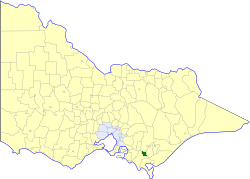
The Shire of Mirboo was a local government area about 160 kilometres (99 mi) southeast of Melbourne, the state capital of Victoria, Australia. The shire covered an area of 255.07 square kilometres (98.5 sq mi), and existed from 1894 until 1994.
(The) Grand Ridge Road is a long tourist drive through Gippsland, in Victoria, Australia. As the name suggests, the road primarily follows ridgelines through the heavily undulating Strzelecki Ranges.
The Great Victorian Rail Trail is the second longest rail trail in Australia, following the route of the former railway line from Tallarook, the Mansfield Railway and Alexandra Railway in north central Victoria, Australia, about 100 kilometres (62 mi) north-east of Melbourne. The trail surface is partially granitic sand and partly chert.
The Mirboo North railway line was a country branch line in Victoria, Australia. It branched from the main Gippsland line at Morwell station, and opened in three stages from 1885 to 1886. The stations along the line were Hazelwood, Yinnar, Boolarra, Darlimurla and Mirboo North.
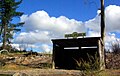
Boolarra is a closed station located in the town of Boolarra, on the Mirboo North railway line railway line in Victoria, Australia.

The Australian bushfire season ran from late December 2008 to April/May 2009. Above average rainfalls in December, particularly in Victoria, delayed the start of the season, but by January 2009, conditions throughout South eastern Australia worsened with the onset of one of the region's worst heat waves. On 7 February, extreme bushfire conditions precipitated major bushfires throughout Victoria, involving several large fire complexes, which continued to burn across the state for around one month. 173 people lost their lives in these fires and 414 were injured. 3,500+ buildings were destroyed, including 2,029 houses, and 7,562 people displaced.
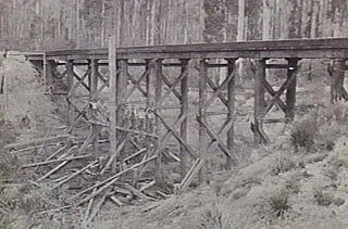
The Noojee railway line is a closed railway line in Victoria, Australia. Branching off from the Gippsland line at Warragul station, it was built to service the timber industry in the upper Latrobe River area, transporting timber as well as providing a general goods and passenger service to townships in the area. The final section of the line between Neerim South and Noojee traversed increasingly hilly terrain and featured a number of large timber trestle bridges. Extensively and repeatedly damaged by bushfires over the years, the line was closed in the 1950s and dismantled. The last remaining large trestle bridge on the line has been preserved and has become a popular local tourist attraction.

The Cynwyd Line is a SEPTA Regional Rail line from Center City Philadelphia to Cynwyd in Montgomery County, Pennsylvania. Originally known as the Ivy Ridge Line, service was truncated on May 17, 1986, at its current terminus at Cynwyd.

The Rosendale Trestle is a 940-foot (290-meter) continuous truss bridge and former railroad trestle in Rosendale Village, a hamlet in the town of Rosendale in Ulster County, New York. Originally constructed by the Wallkill Valley Railroad to continue its rail line from New Paltz to Kingston, the bridge rises 150 ft (46 m) above Rondout Creek, spanning both Route 213 and the former Delaware and Hudson Canal. Construction on the trestle began in late 1870, and continued until early 1872. When it opened to rail traffic on April 6, 1872, the Rosendale trestle was the highest span bridge in the United States.

WR Draw is an out-of-service railroad bridge crossing the Passaic River between Newark and the Arlington section of Kearny, New Jersey. The plate girder rim-bearing swing bridge, originally built in 1897 and modified in 1911 and 1950, is the 14th bridge from the river's mouth at Newark Bay and is 8.1 miles (13.0 km) upstream from it. Last used for regular passenger service in 2002, it is welded in closed position as its height is not considered a hazard to navigation.