Inner Circle railway line

Last updated

Inner Circle
Inner Circle from Royal Pde.jpg
A section of the Inner Circle line between Royal Parade and The Avenue, Parkville.
Overview
StatusClosed line - Inner Circle Rail Trail (part of the Capital City Trail)
Owner
Locale Melbourne, Victoria, Australia
Termini
Continues from Upfield
Continues as Mernda
Connecting lines Mernda, Upfield, Whittlesea lines
Stations
  • 3 current stations
  • 3 former stations
Service
TypeFormer Melbourne suburban service
Operator(s)
History
Commenced8 May 1888 (1888-05-08)
Opened
  • Royal Park to Rushall on 8 May 1888 (1888-05-08)
  • North Fitzroy to Fitzroy on 8 May 1888 (1888-05-08)
  • North Fitzroy to Merri on 8 October 1889 (1889-10-08)
Completed8 October 1889 (1889-10-08)
Electrified
  • Royal Park to North Fitzroy on 5 July 1921 (1921-07-05)
  • North Fitzroy to Merri / Rushall on 14 July 1921 (1921-07-14)
De-electrifiedRoyal Park to Merri / Rushall in c.1961
Closed
  • North Fitzroy to Rushall on 2 May 1965 (1965-05-02)
  • North Fitzroy to Merri on 21 June 1965 (1965-06-21)
  • Royal Park to Fitzroy on 31 July 1981 (1981-07-31)
Technical
Line length
  • Royal Park to Fitzroy: 4.238 km (2.633 mi)
  • Royal Park to Merri: 3.824 km (2.376 mi)
  • Royal Park to Rushall: 3.367 km (2.092 mi)
  • Total track: 5.638 km (3.503 mi)
Number of tracks Single track
Track gauge 1,600 mm (5 ft 3 in)
Route map

Contents

km
BSicon CONTg.svg
Arrow Blue Up 001.svg
BSicon HST.svg
6.7
Royal Park
Victoria bus logo.svg
BSicon SKRZ-ABUE.svg
7.5
Australian state route 38.svgBrunswick Road
BSicon xABZgl.svg
BSicon CONTfq.svg
Arrow Blue Right 001.svg
BSicon exSKRZ-Au.svg
BSicon exHST.svg
7.9
North Carlton
(closed)
BSicon exHST.svg
9.1
North Fitzroy
(demolished)
BSicon exKBHFaq.svg
BSicon exBUEq.svg
BSicon RA.svg
BSicon exABZgr.svg
10.8
Fitzroy
(demolished)
BSicon RAl.svg
BSicon exBUE.svg
BSicon RAq.svg
BSicon CONTg.svg
BSicon exLSTR.svg
Arrow Blue Up 001.svg
BSicon HST.svg
BSicon exLSTR.svg
10.1
Rushall
Victoria bus logo.svg
BSicon eABZgl.svg
BSicon exSTRc2.svg
BSicon exABZ3r.svg
BSicon eABZg+1.svg
BSicon exSTRc4.svg
BSicon hKRZWae.svg
10.2
BSicon SKRZ-Au.svg
10.3
Australian state route 38.svgMerri Parade
BSicon HST.svg
10.5
Merri
BSicon CONTf.svg
Arrow Blue Down 001.svg
km
A map of the Inner Circle railway line Inner-circle-railway-melbourne.png
A map of the Inner Circle railway line
Inner Circle Railway crosses Brunswick Street North.jpg
November 2005
Inner Circle Line Brunswick Street North March 2023 1.jpg
March 2023
Remnants of the Inner Circle railway tracks, crossing Brunswick Street North in Fitzroy North. The line is now a shared user path.
Remains of the former North Fitzroy railway station in 2005 Remains of North Fitzroy Station.jpg
Remains of the former North Fitzroy railway station in 2005
The North Fitzroy Substation, built in 1915 to supply power to the Inner Circle line North Fitzroy Electric Railway Substation .jpg
The North Fitzroy Substation, built in 1915 to supply power to the Inner Circle line

The Inner Circle Line was a steam era suburban railway line (later electrified) in Melbourne, Australia. It served the inner-northern suburbs of Parkville, Carlton North, Fitzroy North and Fitzroy. At its closure, it ran from Royal Park station on the Upfield line in the west to a triangular junction with Rushall and Merri stations on today's Mernda line in the east. There was also a branch line to Fitzroy that opened at the same time.

History

The Inner Circle was opened on 8 May 1888 [1] with three stations: North Carlton and North Fitzroy on the main line, and Fitzroy at the end of a short branch line leading south through the Edinburgh Gardens from a junction near North Fitzroy station.

As the main line

When the Inner Circle line first opened, services originated from Spencer Street station at the western end of the Melbourne central business district. Trains bound for the then terminus at Heidelberg station (now on the Hurstbridge line) would run to North Fitzroy station, then continue south to Victoria Park station (then known as Collingwood, and now on the Hurstbridge and Mernda lines). Locomotives would then have to change ends and the trains return to Clifton Hill station, where they diverged east on to the line to Heidelberg.

In December 1889, after the opening of the Whittlesea line, trains ran from Flinders Street to Whittlesea via the Inner Circle. Other services on the same route only travelled as far as Preston station.

A passenger service was originally provided from Spencer Street to Fitzroy station, on the branch line. By October 1889 this had been relegated to a short shuttle service from North Fitzroy station, and the passenger service closed altogether in May 1892.

For a short period between March and May 1891, the Inner and Outer Circle routes formed the only link between the eastern and western halves of the Victorian Railways system. Prior to that, the link was via a street-level tramway along the edge of the CBD between Flinders and Spencer Streets, which was generally only used at night. Between December 1888 and May 1891, when the new Flinders Street Viaduct, connecting Flinders Street and Spencer Street stations, was in its final stages of construction, the Outer and Inner Circle lines allowed freight trains to bypass the construction site.

Replaced by direct line

In 1901 a new direct line to Clifton Hill was opened from the central Princes Bridge station at the southern edge of the CBD through the inner eastern suburb of Abbotsford. This meant that Heidelberg-bound trains could run direct to their destination, removing the need for the reversal manoeuvre at Victoria Park. The Preston suburban service also ran via the new line. However, Whittlesea trains continued to use the more indirect route via the Inner Circle, albeit only from Spencer Street station.

With the loss of the main line services on the Inner Circle after 1901, a series of "roundabout" services were trialled. By 1906 a regular steam-operated service was established from Princes Bridge to North Fitzroy station via Clifton Hill, and by 1919 this service was running every hour off-peak. [2]

Electrification of the line between Royal Park and Clifton Hill stations was commissioned on 31 July 1921, [2] but the Fitzroy branch was not electrified. Following electrification, passenger services were extended to North Carlton running at 15 minute headways, but from 18 September 1921 they were changed to every 20 minutes. [2] Two trains on weekdays, and a larger number at weekends were extended to Royal Park station to serve patrons of the Melbourne Zoo. [2]

There was the possibility of a revitalisation of the Inner Circle in 1940, when the Ashworth Improvement Plan recommended a subway tunnel with five stations be built under the Melbourne CBD, from Flinders Street to the Inner Circle, with a proposed future subway from the first station to North Melbourne.

Traffic on the Inner Circle was discouraged by the circuitous route and by competition from the more direct trams to the city. [2] Off-peak services were cut to every 30 minutes from 29 May 1944, but from 4 December 1944 20-minute headways were restored on Saturday and Sunday afternoons. The passenger service was finally cancelled on 3 July 1948, and North Carlton and North Fitzroy stations closed to passengers. [2]

Freight only

After 1948 the Inner Circle line was used exclusively for freight trains serving sidings along the line itself, and the goods yard at the end of the Fitzroy branch. The overhead wiring for electric trains was dismantled in 1961. Only the main feeder cables needed for Epping (now Mernda) line trains, and for shunting at the Royal Park end, were retained. [2] Significant changes occurred in 1965, when the line was singled and both legs of the triangle at the eastern end of the line were closed. [1] This left just a single line from Royal Park to Fitzroy remaining for goods services. The line was officially closed on 31 July 1981. [1]

Today

The rails were removed after the final closure, except for some short sections at former level crossings which can still be seen today. From Rushall to Royal Park stations the rail reserve has become a linear park which provides part of the Capital City Trail for cyclists, connecting the Merri Creek Trail to the Moonee Ponds Creek Trail in the network of shared use bicycle paths. Some signals and parts of level crossing gates also survive, with remaining overhead stanchions still carrying railway electric current between the Upfield and Mernda railway lines.

Of the three former stations, only North Carlton still stands, having been converted into a community centre. [3] North Fitzroy station is now a slight rise in the walking and cycling path east of Nicholson Street. The path was realigned in 2002 to traverse the length of the former platform. The site of Fitzroy station has been redeveloped into a medium-density housing estate.

Map of the Inner Circle Rail Trail Map of Inner Circle Rail Trail Stevage.png
Map of the Inner Circle Rail Trail

Station histories

StationOpened [4] Closed [4] AgeNotes [4]
Royal Park 9 September 1884 || || data-sort-value=50,822 | 139 years
North Carlton 8 May 1888 || 15 November 1948 || data-sort-value=22,105 | 60 years
  • Formerly Langridge Street
15 November 1948 || 29 November 1977 || data-sort-value=10,606 | 29 years
  • Freight only
North Fitzroy 8 May 1888 || 15 November 1948 || data-sort-value=22,105 | 60 years
  • Formerly Nicholson Street
15 November 1948 || 11 July 1981 || data-sort-value=11,926 | 32 years
  • Freight only
Fitzroy 8 May 1888 || 9 May 1892 || data-sort-value=1,462 | 4 years
9 May 1892 || 11 January 1981 || data-sort-value=32,388 | 88 years
  • Freight only
Rushall 1 January 1927 || || data-sort-value=35,369 | 96 years
Merri 8 October 1889 || || data-sort-value=48,967 | 134 years
  • Formerly Northcote

See also

Related Research Articles

<span class="mw-page-title-main">Southern Cross railway station</span> Melbourne railway station

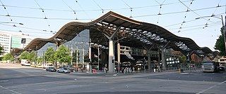
Southern Cross railway station is a major railway station in Docklands, Melbourne. It is on Spencer Street, between Collins and La Trobe streets, at the western edge of the Melbourne central business district. The Docklands Stadium sports arena is 500 metres north-west of the station.

<span class="mw-page-title-main">City Loop</span> Rail tunnel through the Melbourne CBD

The City Loop is a piece of underground commuter rail infrastructure in the central business district (CBD) of Melbourne, Victoria, Australia

<span class="mw-page-title-main">Fitzroy North, Victoria</span> Suburb of Melbourne, Victoria, Australia

Fitzroy North is an inner-city suburb in Melbourne, Victoria, Australia, 4 km (2.5 mi) north-east of Melbourne's Central Business District, located within the Cities of Merri-bek and Yarra local government areas. Fitzroy North recorded a population of 12,781 at the 2021 census.

<span class="mw-page-title-main">Jolimont railway station</span> Railway station in East Melbourne, Victoria, Australia

Jolimont railway station is located on the Mernda and Hurstbridge lines in Victoria, Australia. It serves the inner eastern Melbourne suburb of East Melbourne, and opened on 21 October 1901.

<span class="mw-page-title-main">West Richmond railway station</span> Railway station in Richmond, Melbourne, Victoria, Australia

West Richmond railway station is located on the Mernda and Hurstbridge lines in Victoria, Australia. It serves the inner eastern Melbourne suburb of Richmond, and it opened on 21 October 1901.

<span class="mw-page-title-main">North Richmond railway station</span> Railway station in Richmond, Australia

North Richmond railway station is located on the Mernda and Hurstbridge lines in Victoria, Australia. It serves the inner eastern Melbourne suburb of Richmond, and opened on 21 October 1901.

<span class="mw-page-title-main">Collingwood railway station</span> Railway station in Abbotsford, Melbourne, Victoria, Australia

Collingwood railway station is located on the Mernda and Hurstbridge lines in Victoria, Australia. It serves the north-eastern Melbourne suburb of Abbotsford, and opened on 21 October 1901 as Collingwood Town Hall. It was renamed Collingwood on 1 May 1909.

<span class="mw-page-title-main">Victoria Park railway station, Melbourne</span> Railway station in Melbourne, Australia

Victoria Park railway station is located on the Mernda and Hurstbridge lines in Victoria, Australia. It serves the north-eastern Melbourne suburb of Abbotsford, and it opened on 8 May 1888 as Collingwood. It was renamed Victoria Park on 1 May 1909.

<span class="mw-page-title-main">Clifton Hill railway station</span> Railway station in Melbourne, Australia

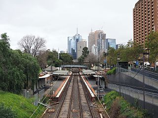
Clifton Hill railway station is the junction for the Mernda and Hurstbridge lines in Victoria, Australia. It serves the north-eastern Melbourne suburb of Clifton Hill, and it opened on 8 May 1888.

<span class="mw-page-title-main">Westgarth railway station</span> Railway station in Melbourne, Australia

Westgarth railway station is located on the Hurstbridge line in Victoria, Australia. It serves the north-eastern Melbourne suburb of Northcote, and opened on 8 May 1888 as Westgarth Street. It was renamed Northcote South on 1 August 1888, and Westgarth on 10 December 1906.

<span class="mw-page-title-main">Greensborough railway station</span> Railway station in Melbourne, Australia

Greensborough railway station is located on the Hurstbridge line in Victoria, Australia. It serves the north-eastern Melbourne suburb of Greensborough, and it opened on 5 June 1902.

<span class="mw-page-title-main">Rushall railway station</span> Railway station in Melbourne, Australia

Rushall railway station is located on the Mernda line in Victoria, Australia. It serves the north-eastern Melbourne suburb of Fitzroy North, and it opened on 1 January 1927.

<span class="mw-page-title-main">Merri railway station</span> Railway station in Melbourne, Australia

Merri railway station is located on the Mernda line in Victoria, Australia. It serves the north-eastern Melbourne suburb of Northcote, and it opened on 8 October 1889 as Northcote. It was renamed Merri on 10 December 1906.

<span class="mw-page-title-main">Lalor railway station</span> Railway station in Melbourne, Australia

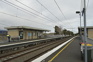
Lalor railway station is located on the Mernda line in Victoria, Australia. It serves the northern Melbourne suburb of Lalor, and it opened in October 1949 as Rail Motor Stopping Place 77. It was renamed Lalor on 27 August 1952.

<span class="mw-page-title-main">Proposed Melbourne rail extensions</span> Extensions to the Melbourne rail network

Proposals for expansion of the Melbourne rail network are commonly presented by political parties, government agencies, industry organisations and public transport advocacy groups. The extensions proposed take a variety of forms: electrification of existing routes to incorporate them into the suburban rail system; reconstruction of former passenger rail lines along pre-existing easements; entirely new routes intended to serve new areas with heavy rail or provide alternative routes in congested areas; or track amplification along existing routes to provide segregation of services. Other proposals are for the construction of new or relocated stations on existing lines, to provide improved access to public transport services.

<span class="mw-page-title-main">Hurstbridge line</span> Passenger rail service in metropolitan Melbourne, Victoria, Australia

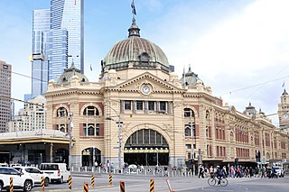
The Hurstbridge Line is a commuter railway line in the city of Melbourne, Victoria, Australia. Operated by Metro Trains Melbourne, it is the city's seventh longest metropolitan railway line at 36.7 kilometres (22.8 mi). The line runs from Flinders Street Station in central Melbourne to Hurstbridge Station in the north-east, serving 28 stations via Clifton Hill Station, Heidelberg Station, Macleod Station, Greensborough Station, Eltham Station, and Diamond Creek Station. The line operates for approximately 19 hours a day with 24 hour service available on Friday and Saturday nights. During peak hour, headways of up to 15 minutes are operated with services every 20–30 minutes during off-peak hours. Trains on the Hurstbridge Line run with a two three-car formations of X'Trapolis 100 trainsets.

<span class="mw-page-title-main">Mernda line</span> Passenger rail service in metropolitan Melbourne, Victoria, Australia

The Mernda line is a commuter railway line in the city of Melbourne, Victoria, Australia. Operated by Metro Trains Melbourne, it is the city's eighth longest metropolitan railway line at 33.1 kilometres (20.6 mi). The line runs from Flinders Street station in central Melbourne to Mernda station in the north, serving 29 stations including Clifton Hill, Reservoir, Epping, and South Morang. The line operates for approximately 19 hours a day with 24-hour service available on Friday and Saturday nights. During peak hour, headways of up to 7.5 minutes are operated with services every 10–30 minutes during off-peak hours. Trains on the Mernda line run with two three-car formations of X'Trapolis 100 trainsets.

<span class="mw-page-title-main">Melbourne Central railway station</span> Train Station in Victoria, Australia

Melbourne Central railway station is an underground station on the electrified railway network in Melbourne, Australia. It is one of three underground stations on the City Loop, which runs through the north and east of the Melbourne CBD.

<span class="mw-page-title-main">Railways in Melbourne</span> Railway network in Melbourne, Victoria, Australia

The Melbourne rail network is a metropolitan commuter and freight rail system serving the city of Melbourne, Victoria, Australia. The commuter rail network is centred around the Melbourne central business district (CBD) and consists of 222 railway stations across 16 lines, which served a patronage of 99.5 million over the year 2021–2022. The network is owned by the Victorian state government and leased to Metro Trains Melbourne, through Public Transport Victoria, a state-run agency. It is the core of the larger Victorian railway network, with regional links to both intrastate and interstate rail systems.

The Whittlesea railway line was a former railway line operating in Melbourne, Victoria, Australia. The line was opened in 1889, with the line now part of the modern day Mernda line.

References

  1. 1 2 3 Vicsig: Inner Circle railway line
  2. 1 2 3 4 5 6 7 S.E. Dornan and R.G. Henderson (1979). Electric Railways of Victoria. Australian Electric Traction Society. ISBN   0-909459-06-1.
  3. Cauchi, Stephen (29 December 2005). "Phantom Trails". The Age . Retrieved 19 December 2016.
  4. 1 2 3 Anderson, Rick (2010). Stopping All Stations. Clunes, Victoria: Full Parallel Productions. ISBN   978-0646543635. OCLC   671303814.