
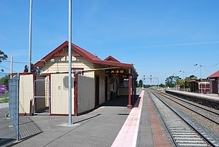
Sunbury railway station is a commuter, regional railway station and the terminus of the suburban Sunbury line and the regional Deniliquin line, part of the Melbourne and Victorian railway networks. It serves the north-western suburb of Sunbury, in Melbourne, Victoria, Australia. Sunbury station is a ground level premium station, featuring two side platforms. It opened on 10 February 1859, with the current station provided in 2012.
Clarkefield railway station is a regional railway station on the Deniliquin line, part of the Victorian railway network. It serves the north-western suburb and town of Clarkefield, in Victoria, Australia. Clarkefield station is a ground level unstaffed station, featuring two side platforms. It opened in December 1862.

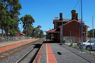
Riddells Creek railway station is a regional railway station on the Deniliquin line, part of the Victorian railway network. It serves the north-western suburb and town of Riddells Creek, in Victoria, Australia. Riddells Creek station is a ground level unstaffed station, featuring two side platforms. It opened on 8 July 1861, with the current station provided in 2014.
Gisborne railway station is a regional railway station on the Bendigo Line, part of the Victorian railway network. It serves the north-western suburb and town of New Gisborne, in Victoria, Australia. Gisborne station is a ground level unstaffed station, featuring two side platforms. It opened on 8 July 1861.

Macedon railway station is a regional railway station on the Deniliquin line, part of the Victorian railway network. It serves the north-western suburb and town of Macedon, in Victoria, Australia. Macedon station is a ground level unstaffed station, featuring two side platforms. It opened on 8 July 1861.

Woodend railway station is a regional railway station on the Deniliquin line, part of the Victorian railway network. It serves the north-western suburb and town of Woodend, in Victoria, Australia. Woodend station is a ground level premium station, featuring two side platforms. It opened on 8 July 1861.

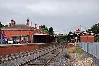
Kyneton railway station is a regional railway station on the Deniliquin line, part of the Victorian railway network. It serves the north-western suburb and town of Kyneton, in Victoria, Australia. Kyneton station is a ground level unstaffed station, featuring two side platforms. It opened on 25 April 1862.
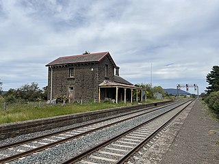
Malmsbury railway station is a regional railway station on the Deniliquin line, part of the Victorian railway network. It serves the north-western suburb and town of Malmsbury, in Victoria, Australia. Malmsbury station is a ground level unstaffed station, featuring a single platform and a disused platform. It opened on 21 October 1862.
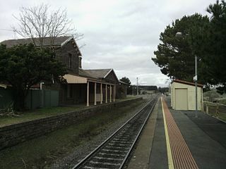
Castlemaine railway station is a regional railway station on the Deniliquin line, part of the Victorian railway network. It serves the north-western suburb and town of Castlemaine, in Victoria, Australia. Castlemaine station is a ground level unstaffed station, featuring two side platforms. It opened on 21 October 1862.
Kangaroo Flat railway station is a regional railway station on the Deniliquin line, part of the Victorian railway network. It serves the southern suburb of Kangaroo Flat, in Bendigo, Victoria, Australia. Kangaroo Flat station is a ground level unstaffed station, featuring two side platforms. It opened on 1 February 1874.

The Victorian Goldfields Railway is a 1,600 mm broad gauge tourist railway in Victoria, Australia. It operates along a formerly disused branch line between the towns of Maldon and Castlemaine.
The Tocumwal railway line is a 1,600 mm gauge railway line in Victoria, Australia. The line runs between the border town of Tocumwal in New South Wales to Southern Cross station in Melbourne. The line is used by various passenger and freight trains serving the northern suburbs of Melbourne and northern regions of Victoria.

Echuca railway station is located on the Deniliquin line in Victoria, Australia. It serves the town of the same name, and opened on 19 September 1864.
The Mildura railway line is a heavy rail line in northwestern Victoria, Australia. The line runs from Yelta station to Ballarat station via the settlements of Mildura, Ouyen and Maryborough in an approximate south-southeasterly direction. Initial sections of the line opened from Ballarat in 1874 and the line reached Mildura in 1903.
Carlsruhe railway station is a former railway station located in Carlsruhe, Victoria. The station is located on the Bendigo line and closed in 1982 as part of the New Deal for Country Passengers.

The family of Walker railmotors were a type of diesel railcar operated by the Victorian Railways in Australia.
The Moolort Line was a cross-country railway line which connected Maryborough and Castlemaine in Victoria, Australia. The line, now defunct, starts in Castlemaine, passes through Campbells Creek, Yapeen, Guildford, Strangways, Newstead, Moolort, and Carisbrook, before joining the Mildura line at Maryborough.
The Bendigo line is a regional passenger rail service operated by V/Line in Victoria, Australia. It serves 14 stations towards its terminus in the regional city of Bendigo. It is the third most-used regional rail service in Victoria, carrying 2.06 million passengers in the 2022-23 financial year.
 The portal of the Big Hill railway tunnel, 390 metres long
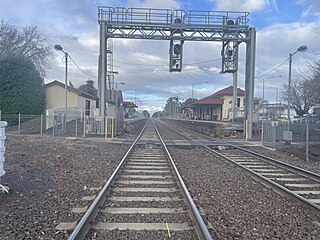
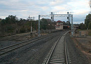 A mix of new and old signalling at Castlemaine station
 Sunbury Station prior to electrification

