
Traralgon is a town located in the east of the Latrobe Valley in the Gippsland region of Victoria, Australia and the most populous city in the City of Latrobe and the region. The urban population of Traralgon at the 2021 census was 26,907. It is the largest and fastest growing city in the greater Latrobe Valley area, which has a population of 77,168 at the 2021 Census and is administered by the City of Latrobe.

Morwell is a town in the Latrobe Valley area of Gippsland, in South-Eastern Victoria, Australia approximately 152 km (94 mi) east of Melbourne.

The Latrobe Valley is an inland geographical district and urban area of the Gippsland region in the state of Victoria, Australia. The traditional owners are the Brayakaulung of the Gunai nation. The district lies east of Melbourne and nestled between the Strzelecki Ranges to the south and the Baw Baw Ranges, part of the Great Dividing Range, to the north. Mount St Phillack is the highest peak to the north of the Latrobe Valley, due north of Moe. The highest peak to the south is Mt Tassie, south of Traralgon.

Morwell railway station is located on the Gippsland line in Victoria, Australia. It serves the town of Morwell, and it opened on 1 June 1877.
Mirboo North is a town in Victoria, Australia, located 150 kilometres (93 mi) east of Melbourne, with a population of 1,697. It is in the South Gippsland Shire local government area.

The Strzelecki Ranges is a set of low mountain ridges located in the West Gippsland and South Gippsland regions of the Australian state of Victoria.
Boolarra is a small township located in the Latrobe Valley, in central Gippsland, Victoria, Australia. At the 2016 Census, Boolarra had a population of 973 with 48% males and 52% females and an average age of 50. The Boolarra Folk Festival is held in the town every year in March and attracts music lovers from around Australia and the world. The town is also infamous for producing the Boolarra strain of carp which, after their release into the Murray River near Mildura, spread throughout Australia.

The Gippsland line is a railway line serving the Latrobe Valley and Gippsland regions of Victoria, Australia. It runs east from the state capital Melbourne through the cities of Moe, Morwell, Traralgon, Sale and terminating at Bairnsdale.
The Midland Highway is a major rural highway linking major towns in Victoria, beginning from Geelong and winding through country Victoria in a large arc through the cities of Ballarat, Bendigo and Shepparton, eventually reaching Mansfield at the foothills of the Victorian Alps.
The South Gippsland railway line is a partially closed railway line in Victoria, Australia. It was first opened in 1892, branching from the Orbost line at Dandenong, and extending to Port Albert. Much of it remained open until December 1994. Today, only the section between Dandenong and Cranbourne remains open for use. The section of the line from Nyora to Leongatha was used by the South Gippsland Tourist Railway until it ceased operations in 2016. The section from Nyora to Welshpool, with extension trail to Port Welshpool and a portion of the former line at Koo Wee Rup, have been converted into the Great Southern Rail Trail.

Yinnar is a rural Australian township located in the Latrobe Valley in central Gippsland, Victoria. At the 2016 census, Yinnar had a population of 907. The origin of the name "Yinnar" is believed to have been derived from the local Aboriginal term yinnar, meaning "woman".

The Murwillumbah railway line is a mostly disused railway line in far north-eastern Northern Rivers New South Wales, Australia. The line ran from Casino to Lismore, Byron Bay, Mullumbimby and Murwillumbah, opening in 1894. It is one of only two branches off the North Coast line,. Train services to the region ceased in May 2004. The line from Casino to Bentley and Murwillumbah to Crabbes Creek was formally closed on 23 September 2020 to facilitate the construction of a rail trail.
The Shire of Mirboo was a local government area about 160 kilometres (99 mi) southeast of Melbourne, the state capital of Victoria, Australia. The shire covered an area of 255.07 square kilometres (98.5 sq mi), and existed from 1894 until 1994.

The City of Morwell was a local government area about 150 kilometres (93 mi) east-southeast of Melbourne, the state capital of Victoria, Australia. The city covered an area of 670.81 square kilometres (259.0 sq mi), and existed from 1892 until 1994.

The Grand Ridge Rail Trail or Mirboo North to Boolarra Rail Trail is a 13 kilometre rail trail in the Strzelecki Ranges of west central Gippsland, connecting the towns of Mirboo North and Boolarra. The route follows the line of the former Mirboo North railway line for the entire distance.
Two different railway lines serviced Yallourn during its existence. Both were broad gauge branches from the main Gippsland line in Victoria, Australia. The first was a line branching from a junction at Hernes Oak, situated between Moe and Morwell, which was in service from 1922 to 1955. The second Yallourn railway line junctioned at Moe, and was used between 1953 and 1986.
The Portland railway line is a railway line in south-western Victoria, Australia. It runs from the main Western standard gauge line at Maroona through Hamilton to the port town of Portland.

The Cudgewa railway line is a closed railway line in the north-east of Victoria, Australia. Branching off the main North East line at Wodonga it ran east to a final terminus at Cudgewa. The High Country Rail Trail now uses most of the railway reserve.

The Australian bushfire season ran from late December 2008 to April/May 2009. Above average rainfalls in December, particularly in Victoria, delayed the start of the season, but by January 2009, conditions throughout South eastern Australia worsened with the onset of one of the region's worst heat waves. On 7 February, extreme bushfire conditions precipitated major bushfires throughout Victoria, involving several large fire complexes, which continued to burn across the state for around one month. 173 people lost their lives in these fires and 414 were injured. 3,500+ buildings were destroyed, including 2,029 houses, and 7,562 people displaced.
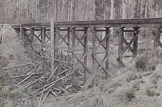
The Noojee railway line is a closed railway line in Victoria, Australia. Branching off from the Gippsland line at Warragul station, it was built to service the timber industry in the upper Latrobe River area, transporting timber as well as providing a general goods and passenger service to townships in the area. The final section of the line between Neerim South and Noojee traversed increasingly hilly terrain and featured a number of large timber trestle bridges. Extensively and repeatedly damaged by bushfires over the years, the line was closed in the 1950s and dismantled. The last remaining large trestle bridge on the line has been preserved and has become a popular local tourist attraction.
