Related Research Articles
Mordialloc railway station is located on the Frankston line in Victoria, Australia. It serves the south-eastern Melbourne suburb of Mordialloc, and it opened on 19 December 1881.

Oakleigh railway station is a commuter railway station in the suburb of Oakleigh in the south-east of Melbourne, Victoria, Australia. The station opened in 1877 as the up end of the Gippsland line, with the station being electrified in 1922. The station consists of two sides that are connected to each other via the adjacent roads, and both platforms are connected to each other via a pedestrian subway.

Westall railway station is located on the Pakenham and Cranbourne lines in Victoria, Australia. It serves the south-eastern Melbourne suburb of Clayton South, and opened on 6 February 1951.

Sandown Park railway station is located on the Pakenham and Cranbourne lines in Victoria, Australia. It serves the south-eastern Melbourne suburb of Springvale, and it opened on 19 June 1965.

Macaulay railway station is located on the Upfield line in Victoria, Australia. It serves the inner northern Melbourne suburb of North Melbourne, and it opened on 1 December 1887 as Macaulay Road. It was renamed Macaulay on 1 May 1909.

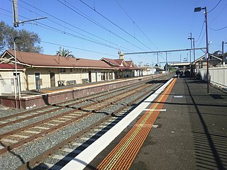
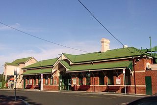
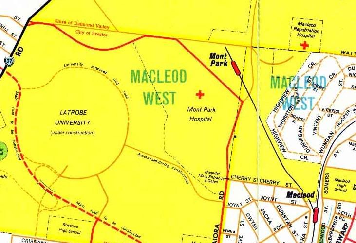
Macleod railway station is located on the Hurstbridge line in Victoria, Australia. It serves the north-eastern Melbourne suburb of Macleod, and it opened on 1 March 1911.

Eltham railway station is located on the Hurstbridge line in Victoria, Australia. It serves the north-eastern Melbourne suburb of Eltham, and opened on 5 June 1902.

The Inner Circle Line was a steam era suburban railway line in Melbourne, Australia. It served the inner-northern suburbs of Parkville, Carlton North, Fitzroy North, and Fitzroy. At its closure, it ran from Royal Park station on the Upfield line in the west to a triangular junction with Rushall and Merri stations on today's Mernda line in the east. There was also a branch line to Fitzroy that opened at the same time.

The Hurstbridge Line is a commuter railway line in the city of Melbourne, Victoria, Australia. Operated by Metro Trains Melbourne, it is the city's seventh longest metropolitan railway line at 36.7 kilometres (22.8 mi). The line runs from Flinders Street Station in central Melbourne to Hurstbridge Station in the north-east, serving 28 stations via Clifton Hill Station, Heidelberg Station, Macleod Station, Greensborough Station, Eltham Station, and Diamond Creek Station. The line operates for approximately 19 hours a day with 24 hour service available on Friday and Saturday nights. During peak hour, headways of up to 15 minutes are operated with services every 20–30 minutes during off-peak hours. Trains on the Hurstbridge Line run with a two three-car formations of X'Trapolis 100 trainsets.

St Kilda station is a current tram stop and former railway station, located in the Melbourne suburb of St Kilda, Australia, and was the terminus of the St Kilda railway line in the Melbourne suburban rail system. It is one of the oldest surviving railway station buildings in Victoria. The building is currently used as retail premises, while the platform serves as stop 132 on tram route 96.
Bacchus Marsh railway station is located on the Serviceton line in Victoria, Australia. It serves the town of Maddingley, and it opened on 10 February 1887.

South Geelong railway station is located on the Warrnambool line in Victoria, Australia. It serves the southern Geelong suburb of South Geelong, and it opened on 1 November 1883.
Australian railway signalling varies between the States of Australia, because the individual States are responsible for the railway systems within their own borders, with, historically, no need to co-ordinate between states except at the boundaries.
The Kew railway line was a former railway line in Melbourne, Australia. The line ran from Hawthorn to Kew. It was opened on 19 December 1887 and was officially closed on 13 May 1957. The last train ran on 18 August 1952 after years of decline.

Benalla railway station is located on the North East line in Victoria, Australia. It serves the town of Benalla, and it opened on 18 August 1873.

General Motors is a disused railway station on the Orbost line in Melbourne, Victoria, Australia. It was previously served by Pakenham line commuter rail services, as part of the suburban rail system. It is located between Dandenong and Hallam stations, in the suburb of Dandenong South.

The APM Siding was a 1.125-kilometre (0.7 mi) long private railway siding in the suburb of Alphington, Melbourne, Australia, that served the Australian Paper Manufacturers paper mill. The siding branched from Fairfield station, on the Hurstbridge line, and ran south-east, passing through the intersection of Chandler Highway, Grange and Heidelberg Roads, and entering the factory.
Two different railway lines serviced Yallourn during its existence. Both were broad gauge branches from the main Gippsland line in Victoria, Australia. The first was a line branching from a junction at Hernes Oak, situated between Moe and Morwell, which was in service from 1922 to 1955. The second Yallourn railway line junctioned at Moe, and was used between 1953 and 1986.

Jolimont Yard was an array of railway lines and carriage sidings on the edge of the central business district of Melbourne, Australia. Located between Flinders Street station, Richmond Junction, the Yarra River and Flinders Street they were often criticised for cutting off the city from the river, being the site of many redevelopment proposals. The Princes Gate Towers were built over part of the yard in the 1960s, which themselves were replaced by Federation Square in the 2000s. The rail sidings themselves were progressively removed from the 1980s to the 1990s with only running lines today, but the area continues to be referred to as the 'Jolimont railyards' by Melburnians.

Hamilton is a railway station located on the Ararat - Portland railway in the town of Hamilton, Victoria, Australia. Today the station is now used only for through trains, and the large station building is used only to serve bus passengers, although the disused platform remains in reasonable condition.
References
- ↑ ARHS Bulletin Search Results
- 1 2 3 4 5 6 7 S.E. Dornan and R.G. Henderson (1979). Electric Railways of Victoria. Australian Electric Traction Society. ISBN 0-909459-06-1.
- ↑ Collection of images of the line, from the Public Record Office Victoria
- ↑ Victorian Acts Enumeration and Revision Act 1958
- 1 2 3 4 Victorian Railways General Appendix to the Book of Rules and Regulations and to the Working Timetable 1953
- ↑ Victorian Railways signal diagram: Macleod station 1955
- ↑ Victorian Railways signal diagram: Westgarth to Macleod 1979
- ↑ Victorian Railways signal diagram: Heidelberg to Macleod 1972
- ↑ Railpage Australia: comment by user chairman