
Yackandandah is a small tourist town in northeast Victoria, Australia. It is near the regional cities of Wodonga and Albury, and is close to the tourist town of Beechworth. At the 2021 census, Yackandandah had a population of 2,008.

Bright is a town in northeastern Victoria, Australia, 319 metres above sea level at the southeastern end of the Ovens Valley. At the 2021 census, Bright had a population of 2,620. It is located in the Alpine Shire local government area.

The Ovens River, a perennial river of the north-east Murray catchment, part of the Murray-Darling basin, is located in the Alpine and Hume regions of the Australian state of Victoria.
The North East railway line is a railway line in Victoria, Australia. The line runs from Southern Cross railway station on the western edge of the Melbourne central business district to Albury railway station in the border settlement of Albury–Wodonga, serving the cities of Wangaratta and Seymour, and smaller towns in northeastern Victoria. The line is owned by VicTrack, but the standard gauge section leased to, and maintained by, the Australian Rail Track Corporation.

Porepunkah is a town in northeast Victoria, Australia on the Great Alpine Road, at the foot of Mount Buffalo 320 kilometres (199 mi) northeast of the state capital, Melbourne and 5 kilometres (3 mi) northwest of Bright. It is part of Alpine Shire local government area and on the banks of the Ovens River, near the Buckland River junction. At the 2016 census, Porepunkah had a population of 941.

The Port Fairy railway line is a railway serving the south west of Victoria, Australia. Running from the western Melbourne suburb of Newport through the cities of Geelong and Warrnambool, the line once terminated at the coastal town of Port Fairy before being truncated to Dennington. This closed section of line has been converted into the 37 km long Port Fairy to Warrnambool Rail Trail. The line continues to see both passenger and freight services today.
The Murray to Mountains Rail Trail is a cycling and walking rail trail in northern Victoria, Australia. It extends from Wangaratta to Bright, with a side branch to Beechworth, following the route of the former Bright railway line. This side branch trail is planned to be extended from Beechworth to Yackandandah. AU$12m was budgeted by the Victoria State Government for this extension in May 2017. Unusually for a rail trail, it is sealed for virtually the entire distance of approximately 95 kilometres.
The Mansfield railway line is a closed 121-kilometre (75 mi) branch railway line situated in the Hume region of Victoria, Australia. Constructed by the Victorian Railways, it branched from the Seymour line at Tallarook station, and ran east to Mansfield. The line was primarily built to provide a general goods and passenger service to settlements in the area.
The Portland railway line is a railway line in south-western Victoria, Australia. It runs from the main Western standard gauge line at Maroona through Hamilton to the port town of Portland.
The Alexandra railway line is a closed 14-kilometre (9 mi) branch railway line situated in the Hume region of Victoria, Australia. Constructed by the Victorian Railways, it branches from the Mansfield line at Cathkin station, and runs east from the town of Cathkin to Alexandra. The line was primarily built to provide a general goods and passenger service to townships in the area.

The Cudgewa railway line is a closed railway line in the north-east of Victoria, Australia. Branching off the main North East line at Wodonga it ran east to a final terminus at Cudgewa. The High Country Rail Trail now uses most of the railway reserve.
Bowser is a closed railway station located just north of the city of Wangaratta, on the North East line, in Victoria, Australia. It served as the junction for the Peechelba East and Bright branch lines. The location was finally abolished as a block point after the conversion of the broad gauge line to form a centralised traffic control double track railway in 2010.
The Yackandandah railway line was a railway line in Victoria, Australia, constructed by the Victorian Railways. It was one of the earliest branch lines constructed in Victoria. The line served the major regional town of Beechworth, which had been active in campaigning for the main rail route into New South Wales to run via the town.
Myrtleford railway station was located on the Bright line serving the town of Myrtleford in Victoria. It opened on 17 December 1883 as the terminus of the line. On 17 October 1890, the line was extended to Bright. On 30 November 1983 it again became the terminus when the line to Bright closed. It along with the rest of the line closed on 13 April 1987.

Bright railway station is the closed terminus station of the Bright line which served the town of Bright in Victoria (Australia). It opened on 17 October 1890 and closed on 30 November 1983.

The Colbinabbin railway line is a closed 42-kilometre (26 mi) branch railway line situated in both the Hume and Loddon Mallee regions of Victoria, Australia. Constructed by the Victorian Railways, it branches from the Shepparton line at Murchison East station, and runs west from the town of Murchison East to Colbinabbin. The line was primarily built to serve the grain industries as well as providing a general goods and passenger service to townships in the area.
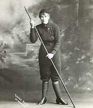
Alice Manfield commonly known as Guide Alice, was a mountain guide, amateur naturalist, chalet owner, photographer, and early feminist figure from Victoria, Australia. Her pioneering work at Mount Buffalo from the 1890s to the 1930s led to her becoming a tourist attraction in her own right, and helped lead to the establishment of the Mount Buffalo National Park.
Porepunkah railway station was located on the Bright line serving the town of Porepunkah in Victoria. It opened on 17 October 1890 and closed on 30 November 1983.
The Girgarre railway line is a closed 23-kilometre (14 mi) branch railway line situated in the Loddon Mallee region of Victoria, Australia. Constructed by the Victorian Railways, it branches from the Colbinabbin line at Rushworth station, and runs north from the town of Rushworth to Girgarre. The line was primarily built to serve the livestock and other farm industries as well as providing a general goods and passenger service to townships in the area.
